Tuesday, June 07, 2022

Cambridge, MA, USA City Council action on bike release from the Grand Junction bike path.

The Cambridge City Council apparently voted for the worst of the three currently possible options for the feeding of bikes off the bike highway proposed for the Grand Junction railroad, the option to feed bikes into a Boston based traffic problem on Brookline Street in Cambridge.  The net impact of this vote keeps open the real goal which is to con the Massachusetts Department of Transportation into accepting feeding bikes into MassDOT’s I90 rebuild in Boston, arguing that “they tried” but “accidentally” created a nightmare, and could MassDOT please give in and sneak the dirty stuff related to the Grand Junction into MassDOT’s plans?

The key committee vote came THE DAY AFTER my letter on the Grand Junction bike path would have been received by the City Council IF THE CITY CLERK’S OFFICE HAD HANDLED THAT LETTER IN ACCORDANCE THE VERY CLEAR RULES.

Rejected without discussion was Massachusetts Institute of Technology (MIT)’s 2014 proposal to feed bikes onto the “Fort Washington” connector.  Several months ago, the City Council WITHOUT MENTIONING THE IMPACTS voted to rearrange easements in the area of the Fort Washington Connector in association with the coming MIT dorm.

Since my last report, I got the following on that Ft. Washington connector:

* * * *

I took a walk over to Vassar Street the other day. That new MIT dorm project is simply massive, taking up a huge lot perhaps 200 yards on either side of the former walkway to Ft Washington. That park is going to be in permanent shade in the AM with the 10 story monstrosity they've building. Pile driving continues every afternoon too, will all summer. They're sinking them in just a few feet apart, subsoil is all landfill, just sand, mud, and clay under that.

* * * *

Here is MIT’s idea of an appropriate dormitory in that location.  The monster building at the bottom of the photo is a few hundred feet from the Fort Washington crossing where the dormitory work was seen.  The construction is probably to its right just before the bottom edge of the photo.

This is taken from “From Cambridge to Boston with the DJ Inspire 1 Drone footage,” https://www.youtube.com/watch?v=sN-OmMzvHhw, minute 8.12.

* * * *

This is MIT’s 2014 map showing the three routes with my modification to the map added.

The two parallel lines feeding to the upper right corner are the upper, the Grand Junction, and below that, Vassar Street.

The brown line connecting them is the route MIT proposed to use for bikes coming on the bike path, and #1 was MIT’s identification of the Bike Route to Memorial Drive.

The broken line which I wrote in between the Grand Junction and Vassar Street is the suggestion of Friends of the White Geese.

Also taken from MIT’s 2014 package is the following areal photo of the area.  


The Grand Junction is at the top.  The connector would go to the left of the white building next to the Grand Junction, then to Vassar Street at its curve and then to Memorial Drive.  Parking replaced by the connector could in turn be replaced by constructing a parking platform above the large parking lot below the white building with deeded parking spaces for the respective users.

#2 is the dangerous intersection that the bikes will now be sent to.

* * * *

Our publication of our letter on the Charles River White Geese Blog was posted on May 6, 2022 at https://charlesriverwhitegeeseblog.blogspot.com/2022/05/positive-news-on-grand-junction-with.html.  The letter was HAND CARRIED to the City Clerk on Monday, May 9, 2022, three days ahead of the May 12, 2022 deadline to get it into the agenda for the May 16, 2022 meeting.  The official record of the eventual May 23, 2022 city council posting, WITH THE STAMPED RECEIPT DATE OF May 9, 2022 on the first page may be seen in official city records at:  https://cambridgema.iqm2.com/Citizens/FileOpen.aspx?Type=1&ID=3656&Inline=True, pages 62 to 76.

Our publication of our letter on the Charles River White Geese Blog was posted on May 6, 2022 at https://charlesriverwhitegeeseblog.blogspot.com/2022/05/positive-news-on-grand-junction-with.html.  The letter was HAND CARRIED to the City Clerk on Monday, May 9, 2022, three days ahead of the May 12, 2022 deadline to get it into the agenda for the May 16, 2022 meeting.  The official record of the eventual May 23, 2022 city council posting, WITH THE STAMPED RECEIPT DATE OF May 9, 2022 on the first page may be seen in official city records at:  https://cambridgema.iqm2.com/Citizens/FileOpen.aspx?Type=1&ID=3656&Inline=True, pages 62 to 76.

Other striking parts exist in the City Council “record” on the City Budget.  The records of the meetings of the Finance Committee, the governing committee, were kept secret until the day of the release of the agenda for the June 6, 2022 meeting.  The portion removed from secrecy prior to the June 6 vote was two pages long.  It briefly states the votes which occurred, PERIOD.  Normally such reports are massive.  NOTHING OF FURTHER DETAIL WAS IN THE PUBLIC RECORD AS OF THE BLOG PUBLICATION OF THIS POST ON June 7, 2022, 11:36 pm.  The “final actions” report was posted on June 8, 2022.  That ADDED to the two pager City Manager input bringing the TOTAL COMMITTEE REPORT up to 11 pages, page 187 to 197 at https://cambridgema.iqm2.com/citizens/FileOpen.aspx?Type=15&ID=2531&Inline=True.

NEITHER report related to the June 6, 2022 meeting reported OUR LETTER BEING RECEIVED by the Finance Committee AT ALL.


Monday, June 06, 2022

Cambridge, MA, USA City Council Meeting for June 6, 2022 is announced to be VERY LATE if at all.

Part of the POSSIBLE agenda for tonight is the future of the Grand Junction Railroad in the eastern / southern part of Cambridge and the Free Animal habitat on the Charles River consisting of the Destroyed Nesting Area of the Charles River White Geese and residence of untold others.

The chair announced at the beginning of the regular meeting at 5:30 pm that the Special Meeting scheduled for 6 p.m. to interview and select a new City Manager will proceed promptly at 6 pm.

She also announced a sign up for public comment for the regular meeting which will run past 6 p.m.  And announced that public comment will also be conducted at the beginning of the special meeting.

If they hire a City Manager tonight, it is highly unlikely, I would think, that the regular meeting will proceed after the hiring.


Friday, June 03, 2022

“Switching” Trains on the Grand Junction Railroad, Cambridge, MA, USA

 “Switching” Trains on the Grand Junction Railroad.

This coming Monday, it would appear that the Cambridge City Council will be deciding on the future of the Grand Junction "Path" adjacent to the Grand Junction Railroad in Cambridge, or, at least, they are voting on funding.

I analyzed the Grand Junction “Path” situation in my post at https://charlesriverwhitegeeseblog.blogspot.com/2022/05/positive-news-on-grand-junction-with.html, entitled “Positive News on the Grand Junction, WITH MAJOR CAVEATS.”   That was my blog publication of a letter I filed for the Cambridge City Council on May 9, 2022.  The official publication is at https://cambridgema.iqm2.com/Citizens/FileOpen.aspx?Type=1&ID=3656&Inline=True, May 23, 2022 City Council meeting, communication 1, pages 62 to 76,

A decidedly impressive 15 minute video entitled “What is the Readville Switcher? | Rare Trains on the Grand Junction” has come to my attention.  It is posted at https://www.youtube.com/watch?v=d3BhmY7MB5Q.  It does not show the Charles River White Geese, “but it does a downright beautiful job of presenting the switching trains which run on the Grand Junction, including videos of the switching trains as far away as South Station.  The creators name is in the record as Boston by Rail.

Here is a still from South Station, at minute 0.20 of the video.  The structure overhead is the central Bus Station over the South Station tracks.


He presents shots at various points in their runs.

From minute 1.23 is a photo on the main line from Boston to Worcester.  I believe that is the southern side of the Commonwealth Avenue Bridge to the left and the Carlton Street Bridge straight ahead.  The extension of the Carlton Street Bridge becomes an on / off ramp from Soldiers Field Road / Storrow Drive eastbound on the  Boston University campus.  To the right of the camera is a very narrow sliver of Boston with Brookline less than a block away.


Here, from minute 5.45, shot from the BU Bridge, is a view of a switcher train on the other, northern side of the Commonwealth Avenue Bridge.  It is viewed across I90, the Mass. Pike.  The building straight ahead is Boston University (BU)’s Fine Arts Building.  The tall ones are dormitories.


The green sign over the highway is visible in our standard photo of the Boston end of Grand Junction bridge over the Charles River.

Here, from minute 11.04 is a view of those same tracks taken from next to the BU class building.  The parking lot is accessory to the building.  To the left is the inbound side of I90 and straight ahead is another view of the northern side of the Commonwealth Avenue bridge.  The building on the upper right is a BU building on the south side of Commonwealth Avenue.  This building is pretty close to the position from which the second previous shot was taken.


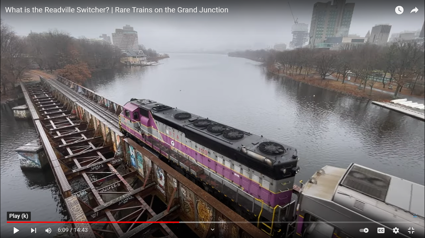
Here, from minute 6.09 is a view of a switcher train crossing the Grand Junction bridge over the Charles River.  The transition from Grand Junction to main line is done under I90 behind the camera in the previous photo.  The trains go reverse directions in the process.  It comes onto the main line going west bound (behind the camera) and switches to east bound, the view in the prior picture.


To the right is that portion of Soldiers Field Road / Storrow Drive to which the Carlton Street extension connects.  For the record, as is normal in the Boston area, they change the name of the street.  I think this block is called University Road.  Confusing drivers with multiple names for the same street is part of a way too common lack of concern for highway safety in New England government.

Various Boston University buildings are visible on the far side of the boulevard which is beyond the parkland which is visible.  The tall building is the Law School.

Visible at the top left is an edge of the Destroyed Nesting Area of the Charles River White Geese.  Then comes the Wild Area, for which the con artists  are constantly dreaming up reasons to destroy.  Then, the yellow building at the water’s edge is Boston University’s boat house on the Cambridge side.  Above that is the Hyatt Regency Hotel which is seen in next photo from a different angle.

Here from minute 1.10 is a view of a train on the Grand Junction in Cambridge with the Hyatt Regency above.  The fairly near building visible is at the near end of a series of buildings which ends with the parking lot through which we propose a connector be built from the Grand Junction Path to the Vassar Street turn.  The parking lot on the opposite side of the connector where we propose a parking platform for replacement parking is just west of the Hyatt Regency complex.  Straight ahead to the right is the general location of where the City Manager’s proposed connector for the Grand Junction Path to Brookline Street.


The building straight ahead and to the left is the building around which Vassar Street turns.  The building straight ahead and to the right is a former Ford Plant, then a Polaroid building,  then a Massachusetts Institute of Technology (MIT) building.  Last I heard it is now owned by Harvard.  It is visible in a lot of photos taken from the Destroyed Nesting Area on the other side of Memorial Drive. 

Here from minute 11.58 is a view identified by the creator as Fort Washington Park with a switch train straight ahead.  I do not recognize the park.  Straight ahead is the monster dorms built by MIT with Cambridge assistance as a method of forcing the MBTA to build a proposed subway through the Wild Area.  That will not happen, as I analyzed in detail in the Grand Junction Path analysis. 


This, to the right, would be the Fort Washington Crossing, MIT’s 2014 proposed exit for the Grand Junction Path which could be the site of the easement transfers voted by the Cambridge City Council for a new dorm.  That new dorm could block MIT’s 2014 proposed exit for the Grand Junction Path.

Further on up, from minute 2.13, is a Switcher crossing Massachusetts Avenue on the Grand Junction.  The building identified as Metropolitan Storage has not been used for Storage for years.  It was purchased by MIT and used for its purposes.


And here, from minute 7.22 is a switch train crossing Main Street, the next major street north of Massachusetts Avenue.  At this point, MIT has built a building above the Grand Junction.


Here, from MIT’s 2014 report to the Cambridge City Council on the Grand Junction path, is MIT’s map placing things in perspective.


The Grand Junction Path is identified and marked in red as relevant to this discussion.

City Streets are shown in blue lines.  The upper end of the marked Grand Junction Path is Main Street.  The line below that line is Massachusetts Avenue.  It becomes the next bridge crossing the Charles River to the right (east) of the BU Bridge.

Since this is MIT’s map, the lower end of that colored line would appear to be at the Fort Washington crossing.  To the left of the Grand Junction Path marking, you can see a blue line for Vassar Street running below the Grand Junction, including the Vassar Street turn to which our proposal connects.  The broken brown line indicates the Grand Junction Railroad.  The Grand Junction, on the Boston side, is shown traveling to the west.  This map does not show the main line to the east to which the video devotes a lot of attention.

Trains which have been seen in the above photos, if they are coming through Cambridge to South Station, follow the Grand Junction railroad as shown on this map, transfer to the main line to Worcester on the Boston side and reverse direction traveling to the east and eventually wind up at South Station.  This part of the route is not shown in this map.

A caveat.  I am passing on this report because it really does an excellent job communicating current use of the Grand Junction.  I have two years actual railroad experience and for at least five years, I have been working on the state's analysis of rebuilding to be done on I90, including its relationship to the Grand Junction Railroad.  I am in no way claiming this video is perfect in all its analyses.  I am simply passing it on because it does an excellent job.


Friday, May 06, 2022

Positive News on the Grand Junction, WITH MAJOR CAVEATS.

Positive News on the Grand Junction, WITH MAJOR CAVEATS.

[Ed:  This posting has been modified from its original posting.  It was first intended to be a draft for a letter to the Cambridge City Council, its Finance Committee and the Cambridge City Manager.  In the process of finalizing a number of changes were made.  This posting has been updated to reflect the changes as submitted on May 9, 2022.]


1, Introduction.

2. Caveat.

3. Possible Details.  Area omitted by the City Manager’s funding proposal — General.

A. The Grand Junction Railroad Bridge.

B. The Wild Area and the Destroyed Nesting Area.

4. Limited Overview.  The part omitted by the City Manager in his funding proposal.

5. Limited Overview.  The responsible portion of the Grand Junction “Path” funded by the Cambridge City Manager and proposed by the City Manager for funding by the Cambridge City Council.

6. Supplement.


1, Introduction.

Con artists in Cambridge, MA, are fighting for aa whole bunch of destructive things.  The Grand Junction Railroad in the eastern part of Cambridge is pivotal in a whole bunch of things.  Here is a simplified map from the Massachusetts Department of Transportation (MassDOT):


The Grand Junction in Cambridge starts at its railroad bridge over the Charles River at the bottom of the map.  It then proceeds diagonally up and to the right, then straightens out into a path directly up, crossing the municipal boundaries near the top of the map.

At the point where the Grand Junction and the Charles River interconnect in Cambridge is the last remaining abode of free animals for miles.  Here is a close up of that area and the adjacent Magazine Beach recreation area.  The BU Bridge is at the bottom and the Grand Junction Railway bridge may be seen crossing under it.  My notes indicate that the source of this map is the Massachusetts Department of Conservation and Recreation (DCR).

The area which is the last remaining abode of free animals is above the Charles River between the two bridges, along with the area to its right.

The tourist loved Charles River White Geese are the most visible, BUT BY NO MEANS THE ONLY, residents.  The Charles River White geese have lived on the Charles River for 42 years.  During most of that time their main habitat AND FOOD was at the Magazine Beach Recreation Area.  The habitat was approximately a mile long centered on the B.U. Bridge.

Heartless abuse and deliberate starvation by governmental entities have confined the Charles River White Geese to the animal habitat,  their Destroyed Nesting Area.  Here is a winter photo of a group of  them there admiring the Charles.  The structure in the background above their heads is the Grand Junction Railroad Bridge.


One of the currently active destructive cons is called the “Grand Junction Path” for bicycles.

My most recent blog report on the details of the “Grand Junction Path” was my letter to the Cambridge City Council of February 16, 2021.   This is posted on official page of Friends of the White Geese at:

http://www.friendsofthewhitegeese.org/ar1.htm.  The official version is posted by the City of Cambridge at http://cambridgema.iqm2.com/Citizens/FileOpen.aspx?Type=1&ID=2394&Inline=True, city council agenda for their March 15, 2021 meeting, pages 131 to 161.

On May 2, 2022, the Cambridge City Council was considering money for the Grand Junction Path in City Manager’s Agenda item 5 as follows:

“[T]he appropriation and authorization to borrow $15,000,000 to provide funds for the design and construction of a multi-use paths [2 proposed not relevant to this analysis omitted], and Grand Junction Path, which runs from Henry Street to Gore Street on both City, MIT and MassDot property.”

Final decision appears to be due on June 8, 2022.


2. Caveat.

The deletion of a major  portion of the way this project has been described by the Cambridge Development Department as stated in section 4 is good.

There is a very major defect, however.

The Massachusetts Department of Conservation and Recreation is proposing a Part III of its destructive outrages for Memorial Driver to impact that part of Memorial Drive which runs on the Charles River from west of Harvard Square to the area which has been omitted in the City Manager’s Grand Junction Path funding proposal.  The omission in the funding request is of that destructive segment which has been skillfully and repeatedly alluded to during discussion of the Grand Junction Path proposal.

I have spent way too much time on responding to this outrage by whatever name is currently being used.

The deletion of overlap with the DCR on the Charles River is nice.  The responsible thing is to end the destruction on the Charles River and these non stopping outrages.  The important thing is a lot more than just being nice.

The only viable way to do stop the destruction on the Charles River, has to be by action of the legislature.  The legislature has to finish what the legislature tried to do ten years or so ago.  Then the legislature destroyed the Metropolitan District Commission, among other reasons, to protect the Charles River from the destruction and incompetence of the MDC.  

In working to protect the Charles River, the legislature replaced the Metropolitan District Commission on the Charles with the Massachusetts Department of Transportation and the Massachusetts Department of Conservation and Recreation. 

The “planners” from the MDC transferred to the DCR with their destructive plans and have already accomplished massive destruction consistent with those plans.  The DCR initiative included massive destruction YEARS AFTER ITS “REVIEWS” had passed the end of their period of validity.  Now the DCR is reinvigorating a proposal which has spent years in a well deserved oblivion.  

The legislature must salvage what can be salvaged from its destruction of the MDC.  The legislature must fire the DCR on the Charles River and transfer all its duties on the Charles River to the Massachusetts Department of Transportation.  The Cambridge City Council can AND SHOULD demand this from the legislature.

MassDOT is not perfect but the DCR and the Cambridge City Council approach being perfect from the wrong direction.  MassDOT commonly looks like the adult in the room with two destructive brats. The DCR and Cambridge.

Any and all actions to improve the Charles River which do not include firing the DCR are a con game.  The same applies to the non stop fraud of “protecting trees” in Cambridge coming out of the Cambridge City Council.  If you do not fire the DCR, you are pulling a con game on both issues.  PERIOD.

My video of the outrages accomplished by the DCR and Cambridge in January 2016 between the B.U. Bridge and the Longfellow Bridge may be reviewed at https://www.youtube.com/watch?v=pTplCCEJP7o.  There are a lot more materials.  This is not the place to go into them.


3. Possible Details.  Area omitted by the City Manager’s funding proposal — General.

I have Googled the situation.  The result was a number of entries, but only one recent, from the Cambridge Development Department.  People Googling the subject must be aware that the con artists are very determined even though we keep beating them.  The con artists massively defend their outrageous demands, so they splatter their lovely propaganda and splatter their lovely propaganda.  They also have a record of losing where it counts most, MassDOT.

The key words in this funding order are “Grand Junction Path, which runs from Henry Street to Gore Street on both City, MIT and MassDot property.”

The Grand Junction Railroad in Cambridge is the target for this bicycle highway.

The Cambridge Development Department is selling the Grand Junction Path as running from “pathways proposed in the Allston I-90 Interchange project.”  The Allston I-90 Interchange project is in Boston and  has been extensively discussed on this blog.  

I have not been able to keep in contact with changes during COVID.  

MassDOT has aggressively fought back outrages from the Cambridge con artists to misuse the MassDOT rebuilding of I90 in Boston to piggyback multiple outrages being fought for by Cambridge con artists.  The con artists have been unsuccessful in achieving their goals above board in Cambridge, so they are trying to sneak them through however they can.  MassDOT consistently describes the I90 rebuild project as solely in Boston, PERIOD.  MassDOT has limited the outrages totally insofar as they are clearly impacting Cambridge, and not Boston. 

Abuses on the Grand Junction are exactly what the con artists are fighting for.

Henry Street as stated in the City Manager’s is a responsible alternative as southern terminus of the Grand Junction Path to what the Cambridge con artists are fighting for.

I could go into massive details, but trying to go into massive details on Charles River Planning, plus on putting Charles River planning into the appropriate regional context is the reason why I have not gotten anything out in ages.  The current action is extremely good.  I hope it stays extremely good.


4. Limited Overview.  The part omitted by the City Manager in his funding proposal.

The following is a briefer restatement of our analysis in our February 16, 2021 letter.


A. The Grand Junction Railroad Bridge.

This is a still from minute 1.59 of  “From Cambridge to Boston with the DJ Inspire 1 Drone footage,”

posted at https://www.youtube.com/watch?v=sN-OmMzvHhw.


The bridge very visible over the Charles River is the B.U. Bridge.  Under it is the Grand Junction railroad bridge.  The con artists have floated so many wild claims.  The reality is that they cannot achieve those wild claims without widening the Grand Junction railroad bridge.  MassDOT has constantly fought the demands.  

The nonsensical claims of the Cambridge Development Department on the Grand Junction Path are that the Grand Junction Path should connect to paths associated with the I90 rebuild project translate into widening this bridge AND A LOT OF DAMAGE TO THE CAMBRIDGE RIVERFRONT.  I90 is the major highway below the BU Bridge in this photo and to the right.  The DCR, contrary to the wishes of the legislature is determined to inflict massive destruction on the mature trees on the Charles River and destroy its animal habitat, the last animal refuge for many miles.  The DCR’s contempt for its responsibilities on the Charles River has even extended to the DCR poisoning the Charles River.

Between the Grand Junction railroad bridge and the B.U. Bridge on the Cambridge side is the Destroyed Nesting Area of the Charles River White Geese.  This is the important part of their 42 year habitat on the Charles River which has not YET been destroyed to them by the DCR (Massachusetts Department of Conservation and Recreation) and Cambridge.

The thick green area directly above the DNA is the Wild Area, which is associated with the DNA and is a major part of the undestroyed habitat.  The building directly above it on the river is a boat house which is owned by Boston University.  Boston University dominates the Boston side (at the right and the bottom of the photo) of this part of the Charles River, including a number of big buildings   The Wild Area is a key part of the area which the con artists are fighting to destroy.  I will not go into further discussion here.  Describing this destruction and all the games is a major reason why I have been off line for so long.

The portion of I90 shown in the picture is a major part of the I90 rebuild project.

Here is a photo of the Boston end of the Grand Junction railroad bridge.  This bridge is crucial in the con games.  The con artists fight to widen it.  


The green sign above the furthest point seen of the railroad is above I90.  It is seen mostly from its edge.  Careful review of this picture to the left of that sign shows a car traveling outbound (westerly) on I90.

The metal structure to the right in the picture is part of the portion of the railroad bridge above the Charles River.   Soldiers Field Road, Boston, is the road below the visible portion of the Bridge.  In the prior photo, Soldiers Field Road shows between I90 and the Charles River.


B. The Wild Area and the Destroyed Nesting Area.

Here is a better view of the Wild Area which the con artists want to destroy.  To the left is the Destroyed Nesting Area of the Charles River White Geese.  The tiny white figures are a group of the Charles River White Geese hunting for what little of their food for most of their more than 40 years of residence has not been destroyed to them by government.


In January 2016, the DCR with assistance from the Cambridge Development Department and deafening silence from the Cambridge City Council destroyed hundreds of mostly excellent trees between the B.U. Bridge and the second bridge to its east, the Longfellow Bridge, including almost all of the food of the Charles River White Geese which had not been previously destroyed.

Our video of that outrage is at https://www.youtube.com/watch?v=pTplCCEJP7o.  The plans included destruction of the Wild Area with major destruction in the Destroyed Nesting Area.  That portion of the plans was not accomplished YET.  Explaining the YET is a major reason why I have not been visible for the last month plus.

The City Manager condemned in this video was the predecessor of the current City Manager.  That same City Manager also directly managed the outrages inflicted on Magazine Beach in the 2000's, and directly managed the destruction of 3.4 acres of the “irreplaceable” Silver Maple Forest in the Alewife reservation by Cambridge and the DCR.  The quoted word was frequently used by the Cambridge City Council WHILE KEEPING THE GOVERNMENTAL DESTRUCTION AS SECRET AS POSSIBLE.

Here is the relevant portion of the plans for the January 2016 outrage


.The Grand Junction railroad runs from the bottom left to the top middle.

The left side of the plans is the Destroyed Nesting Area.  The right side of the plans is the Wild Area.

Dealing with the DCR involves repeatedly refuting fraud from the DCR.  An excellent example of that fraud is the tree numbered 535 near the bottom right hand corner of the plan.  The destruction plans give the impression of providing great detail about the destruction.  The fraud is highly obvious in this plan.  

The tree numbered 535 IS THE ONLY WILD AREA  TREE IN THE ABOVE PICTURE WHICH IS SHOWN ON THE DESTRUCTION PLANS.  Clearly it is shown because it is the only tree not planned for destruction.  

So MASSIVE DESTRUCTION IS HIDDEN IN A CLAIM OF PROTECTION.

Major destruction would, “of necessity” be inflicted on the Destroyed Nesting Area as part of this outrage.  A portion of the gaggle of the Charles River White Geese may be seen off the Wild Area in the above photo, desperately hunting for food which had not yet been destroyed.  MUCH MORE OF THEIR FOOD WAS DESTROYED AFTER THE PHOTO WAS TAKEN.

The roadway running from left to right is Memorial Drive, the Cambridge equivalent of Soldiers Field Road.  Road identification on the Boston side is horribly confused.  The Boston boulevard clearly is Soldiers Field Road to the west of the BU Bridge.  To the east the boulevard may or may not have a different name.  Two names are seen when traveling on it.

Above Memorial Drive is part of the very great, although perhaps temporary, victory announced without fanfare by the Cambridge City Manager.  This area to Henry Street is deleted from the Cambridge Development Department’s description of the Grand Junction Path.

Here is another shot of the Charles River White Geese.  It was taken in a BITTERLY COLD WINTER.  The trees visible are the Wild Area in winter.  The cove in which the Charles River White Geese are swimming is a pocket of warmth in the middle of extreme bitter cold.  To the east of this cove is Boston University’s boat house.  To the west of this cove is the Grand Junction Railroad and the Destroyed Nesting Area.


The photo was taken from Memorial Drive’s sidewalk


5. Limited Overview.  The responsible portion of the Grand Junction “Path” funded by the Cambridge City Manager and proposed by the City Manager for funding by the Cambridge City Council.

Here at minute 9.28 of the drone video is the portion of the Grand Junction Railroad / Grand Junction “Path” which is nearest the Charles River.  The current vote’s ending the Grand Junction Path does a very good job of limiting the southern end of the Path to that portion seen here.  I will go into more accurate detail in a later photo.


There are three major arteries visible in this photo, from left to right are the Grand Junction Railroad, Vassar Street and Memorial Drive.  Vassar Street turns toward the river just out of this picture toward the bottom.  With this turn, Vassar Street goes around the building at the bottom of this photo. 

Here is an official, Cambridge Development Department rendition of the Grand Junction Path:

The left most portion of the Grand Junction Railroad / Grand Junction Path is what shows in the photograph.

The Cambridge Development Department provided a simplified rendition.  Here is my cropping of the simplified rendition to that part which is relevant to the current situation.


We interpret Point 2 as Henry Street, the southern terminus which is being considered in the funding vote.  We are using the Development Department map to communicate our point.  

Our identification on points 1 and 2 in the Development Department map IS DIFFERENT from their interpretation in their on line version from which this is taken.  The different interpretation is associated with the MUCH BETTER AND MORE PROFESSIONAL PRESENTATION in the excellent map of the Massachusetts Institute of Technology (MIT) reproduced below.

To the left of and below point 2 is the portion which is omitted from the current proposal.  The longer yellow line is Memorial Drive.  The arrow ends at the B.U. Bridge.  The area bounded by the B.U. Bridge and Memorial Drive minus the protuberance on the right (the B.U. Boathouse) is the Destroyed Nesting Area and the Wild Area.

Point 1 is approximately the point where we have proposed that the bike path end.  NOTE THAT OUR PROPOSAL WOULD PROVIDE A LONGER BIKE PATH THAN IS IN THE FUNDING PROPOSAL. 

Point 3 is the Fort Washington crossing.  This is the point where the 2014 detailed proposal of the Massachusetts Institute of Technology has proposed that the bike path end.

Here are our photos of the tiny taking which would be necessary for the responsible, non nonsense bike path terminus which we propose

The first photo is the view from Vassar Street at the curve of Vassar Street: Our proposed path would run along the building at the right.  The tracks can be seen to the left rear of the building.


We propose that existing parking to the right of the camera be taken as part of the project for the purpose of creating a parking structure providing the combination of parking currently in that location  and replacing with usage right the parking lost in creating the bike connection.

This is the track view from the railroad corner of the building abutting our proposed connection.


Here is a view from across the tracks. The connection would be straight ahead. The
relocation of parking for the connection would be on the near side of the building straight ahead.


Here is a photo from Vassar Street just north of Memorial Drive. Straight ahead is the location of the connection. Bikes would move from the connection on this portion of Vassar Street to Memorial Drive.


Probably the best graphic rendition of this area was presented by the Massachusetts Institute of Technology in its 2014 report presenting the fourth alternate ending, presented below. 

On the back cover of that report is a photographic overview. Here is a crop of that to the location of our proposed connection.

At the top is the Grand Junction Railroad / Grand Junction Path. Below, to the left of the white building is where our proposed connection would go..

Proceeding, across the street is a massive parking lot which could be partially taken to increase capacity  by a parking structure with deeded parking rights as appropriate to the owner of the parking replace by the connection to offset parking taken for the connection.


And the photo gives an excellent rendition of the final leg of our connection, ending the bike path at Memorial Drive.

The first alternate ending is the currently proposed Henry Street alternate.  The second alternate ending is the wild demand from the Cambridge Development Department and the Cambridge con artists that the Grand Junction Path go to I90.  Ours is the third alternate ending.

The fourth, MIT alternate, ending would connect to Vassar Street at Fort Washington and end the path at that point (point 3 in the development department map, above).  Here is MIT’s excellent rendition of the area in question, taken from its 2014 report / proposal.


The Grand Junction Railroad / Grand Junction Path runs from the upper right corner diagonally downward to the bottom at about 1/3 of the way from the left.  Directly below it is Vassar Street with its turn around the building.  Not far from the upper right corner is MIT’s suggested connection of the Bike Path from the Grand Junction to Vassar Street.  The number 1 indicates that this is MIT’s preferred bicycle route ending.  This connector already exists.  It is named the Fort Washington Crossing after the park at its upper end.

Our proposed connection is from the Grand Junction to Vassar Street is written into the map with the broken black line from the Grand Junction to the turn of Vassar Street.  MIT’s rendition has our connection just below Waverly Street (essentially parallel to the top and bottom edges of the map.  Henry Street is the next street above Waverly.  This map shows the reason for our reversal of number identification from the Cambridge Development Department presentation.  Our proposed connection is below both Waverly and Henry streets.  

Somehow, the “Henry Street” proposal being funded gets somewhere, but my understanding is that the end of the bike path follows Waverly Street INTO THE TRAFFIC NIGHTMARE at Brookline Avenue.  By contrast, the MIT proposal and our proposal get to Memorial Drive by way of Vassar Street / Amesbury Street.

Both the MIT alternate and our alternate are safer and saner than the “Henry Street” route which appears to go by way of Waverly Street. #5 identifies the Grand Junction Bridge and #4 is honesty from MIT showing plans to develop the Destroyed Nesting Area which are otherwise kept secret.

The Waverly Street route looks like a design INTENDED TO LOSE.  It is so dangerous that it is nonsensical.  It is, however, far less irresponsible than connecting to I90 which is nonsense.  I think the correct term for the Waverly / Henry route is doppleganger, suicidal and deliberately suicidal.  By contrast, both our connection to the Vassar Street curve and MIT’s connection at Fort Washington are viable routes. 


6. Supplement.

Long experience with the Cambridge City Council breeds well earned skepticism.

A few weeks ago, the Cambridge City Council approved a combination of easements which could very easily block the Forth Washington Crossing.

Secret games repeatedly get played.  At least one easement was confusingly named, to put it mildly.

Here is a drone photo from minute 8.12.


The trees at the bottom are probably Fort Washington Park.  Directly above it is the Grand Junction Railroad, and directly above the railroad is a monstrous MIT dorm between the Grand Junction and Vassar Street.  It was created with zoning games from the Cambridge City Council.  That building blocks a responsible alternative for a subway route in planning.  The alternative preferred by the con artists in Cambridge would destroy the Wild Area.

The easement games which were played were described as RELATED TO AN MIT DORM IN PLANNING, rather clearly between the Grand Junction and Vassar Street.  Would they block the Fort Washington crossing and thus MIT’s alternate bike path route?

If the Cambridge City Council voted to block the Fort Washington Crossing with YET ANOTHER MONSTROUS DORM, the only alternative to Henry Street, whatever “Henry Street” is, is the Grand Junction Path Ending and connection to the Vassar Street turn proposed by Friends of the White Geese.

[signature]

P.S. One of the usual “explanations” for the outrages on the Grand Junction is the Urban Ring subway.

The alternate route favored by the con artists was intended to be forced by blocking that portion of the “Kenmore Crossing” in Cambridge. MassDOT and the legislature very emphatically responded by upgrading the Landsdowne Station which the con artists want to move to make their alternate feasible. Landsdowne Station is a major part of the Urban Ring proposal. Here is the completed Landsdowne Station as part of the beginning of that related project. It would appear that Cambridge’s obstruction has defeated only Urban Ring service to Cambridge. Please be happy, however, in that our proposed Green Line A spur would reduce the overload on the Red Line in Cambridge between Park and Harvard, plus improve service to Harvard Square from the Back Bay, Brookline and Brighton.


As far as the Urban Ring goes, it will likely wind up as an Orange Line spur from Ruggles to Kenmore and the Commuter Rail and Green Line connections at a merged Kenmore / Landsdowne Station because of the very great value to Massachusetts of the Harvard / Longwood Medical Area.

Cambridge con artists have stabbed Cambridge in the back again.

Not at all incidentally, the author suggested the Kenmore Crossing in the first place, and was the first to notify the Landsdowne Place developer of Cambridge’s intentions to move Landsdowne Station. Landsdowne Station was greatly improved by the state in the time between our discussions and the beginning of construction of the station project.

Our Green Line A spur proposal will provide needed connections to the hospitals for current Medical Area schools being relocated from Harvard / Longwood Medical Area to Harvard’s coming Allston Village Campus on the Boston banks of the Charles River. People wanting details of the Green Line A spur should contact us at boblat@yahoo.com. Providing those details here would be way irrelevant to the purpose of this letter. Supporting that the Green Line A spur, however, would be of great value to Cambridge.


Wednesday, March 30, 2022

YET ANOTHER ATTACK ON FREE ANIMALS COMING ON THE CHARLES RIVER?

 Boston.com, at https://www.boston.com/news/local-news/2022/03/29/unhoused-man-attacks-wbz-tv-cameraman-cambridge-city-councilor/?p1=recirc_mostpopular reports a Cambridge City Councilor was attacked by a homeless man while being interviewed by a WBZ reporter.

The report states that Boston’s “clean up” of a homeless encampment near Boston City Hospital has increased the homeless population in Cambridge.

The report states: “[Cambridge City Councilor Marc] McGovern told WBZ unhoused people have flocked to Cambridge since Boston’s sweep of the encampment in the area known as Mass. and Cass months ago. . . .

“. . .WBZ said, tents are appearing in new areas, such as the banks along the Cambridge side of the Charles River.”

That waives all sort of flags.  The powers that be have a striking tendency to attack resident animals ancillary to whatever the latest excuse is.


POSTSCRIPT

I have made the key point relevant to this page.  On the Cambridge Town Hall Facebook page, Corina Hall quoted Marc from his Facebook page.  I am trying to edit the comments down to the substance of the attack:

“ . . .an unhoused man, who appeared to be having a mental health episode, tried to punch me. I was able to block his attempt and he did not make contact, nor was I hurt.
. . .

“The man proceeded to walk into Central Square, where he pushed down at least one other person. The Cambridge Police were called and were able to calm the man down and an ambulance brought him to Cambridge Hospital for evaluation. The Cambridge Police handled the situation professionally and with compassion.”

Tuesday, March 29, 2022

Development “planning” in Boston compared to the Cambridge City Council

 Development “planning” in Boston compared to the Cambridge City Council


Preliminary Notice.

1. Boston Development Plans Contrasted to Secret / DESTRUCTIVE Maneuvers in Cambridge.

2. South Station.

A, South Station proper.

B. South Station, The Rail Yards, and Neighborhood Development.

C. North South Rail.

2. I90 (Mass Pike) growth.

A. Landsdowne Station Development.

B. The I90 (Mass. Pike) Rebuild.

3. Harvard’s coming Mass. Pike / Allston Village campus.

4. The Cambridge Side of the Charles River.

5. Caveats.


Preliminary Notice.

This post is a work in process.


1. Boston Development Plans Contrasted to Secret / DESTRUCTIVE Maneuvers in Cambridge.

NewsBreak reports that Boston Mayor Wu is drastically reducing the development planners in Boston government.

Sounds like Mayor Wu MAY BE more responsible than the Cambridge City Council.

BUT there clearly are a lot of plans in the mix for Boston that have Charles River impact.

A couple of areas of interest are South Station and the Mass. Pike (I90).


2. South Station.

A, South Station proper.

Going in over South Station is a project which clearly indicates the future for the massive rail yards south of South Station and between South Boston and the Boston’s South End.

It will create a 50% increase in the size of the Bus Terminal plus a high rise building.

Here are photos from platform level in 2021.

Below is a shot from the United States Postal Service (USPS) end of the tracks showing the beginning of the skeleton of the structure. 


Below is an angle shot with the Bus Station.  


After that is a shot looking down the tracks at the then not yet obscured original Bus Terminal.  It is now heavily obscured as construction has progressed.


CAVEAT:

Because of the inability to tear down the USPS Fort Point Annex, this project was modified to exclude that portion.

The visible lead agency is part of the City of Boston.

Details from show and tell - South Station Air Rights Project.

Shortly before it started, the developers conducted a show and tell of the project.  To the best of my knowledge, the on line version of this gathering is the only place where the plans are readily available.


My guess is that the model shot shows projected follow-ons.


They seem to have missed the time line in the last slide.


B. South Station, The Rail Yards, and Neighborhood Development.

(1) General.

Here is a Google Maps presentation of the area cropped to show the entire relevant area.  It is very large.  The complex follows I93, the Southeast Expressway, or to be more accurate, the Southeast Expressway was created based on the yard complex.  At the top of the photo is South Station (the red graphic).  Below that is the connections to the Mass. Pike, I90, with the connection to Back Bay Station.  Below that is the widest area, followed by the southern area which approaches JFK / Columbia Station.  The area closest to JFK has been occupied by subsidized housing for a long time.


If you are not familiar with those rail yards (they are very much massive) and are familiar with the rail approach from Philadelphia to New York City, think Manhattan.  Much of Manhattan is built over rail yards just as the project going in at South Station is going in over rail yards.  It is very dark on the passenger trains coming into New York City during the last few miles coming north from Philadelphia.  That darkness comes from buildings constructed on air rights over railroad properties. 


(2) Area 1.

 Here is an enlargement of the South Station area.  The triangular South Station building is at the bottom point of the red graphic.  Below that can be seen the area which is shown above in the construction zone.  The greyish circles are the Bus Terminal which is being expanded.  It is extremely large.  The massive white structure to the right of this area is the USPS Fort Point mail facility.  The area to its right is the Fort Point Channel.


The new building going in over the passenger terminal yard at South Station is very clearly the beginning of much planned expansion.

MassDOT wants to tear down the USPS Fort Point mail facility and relocate it beyond the Boston Convention Center which is perhaps half a mile to the right of the picture and with its main entrance facing the street which is immediately above the South Station building, Summer Street.

Beyond the Boston Convention Center is a hotel and then, beyond the hotel and a few blocks farther below Summer Street are two large empty blocks where MassDOT apparently wants to move the USPS postal facility.

In place of the USPS Fort Point mail facility, MassDOT want to build tracks for South Coast Rail expansion to Taunton, Fall River and New Bedford.  That service is now planned to go by way of a lengthened Middleborough line with the Middleborough station moved from the track from Middleborough to Cape Cod to the track from Middleborough to Taunton.

I90 and I93 have ramps connecting to each other, to local streets, and to the Bus Terminal.  I90 goes underground and underwater to the right of South Station.  The underground connection is greyed into the map.

Above I90 has been mostly filled in for decades with hospital construction and high rise housing.   There is room for construction closest to the South Station / Bus Station complex.  This is the area marked Chinatown.  The recent construction has been below Stuart Street.  

The area above Stuart Street is core Downtown Boston including pretty dense construction in that historical part of Chinatown.  Downtown Boston is beyond the scope of this analysis.


(3) Area 2.

My second breakout of the larger map is here.


The Fort Point channel is visible following I93 and moving to the right along with the buried I90.  The large U shaped building is a perhaps historical industrial building long belonging to Gillette.

Immediately under the Fort Point Channel begins the yards complex and supporting facilities.  First is subway storage for the MBTA’s Red Line subway.

To the left of I93 and below I90 commences new South End residential / office construction including retail.  The portion of this closest to I93 was formerly the Boston Herald Complex.  This series of buildings is two or three blocks wide and  runs for several blocks along I93.  

Here is a photo of the area before the Mass. Pike came in.  The big building is now a Massachusetts government building.  I93 was built beyond the buildings to the bottom and left.  The open area by the lower right corner still contains the East / West railroad to Back Bay Station and then to Worcester.  The photo was provided by Phil Barber.  When it was constructed in the early 70's, I90 followed the railroad.


The circled T to the right in my map breakout is Broadway Station on the Red Line in South Boston proper.  This graphic is the MBTA’s symbol.  Following downwards to the left of the street below the graphic are new buildings abutting the tracks which are larger than the new buildings in the South End south of I90.

The area ripe for construction starts at this point on both sides of the tracks.  It includes the tracks and  runs along the tracks.  The South Boston edge of the construction area is the road commencing below Broadway Station.  Potential construction gets wider.  The Subway and Commuter Rail yards and support structures extend from the Fort Point Channel down, getting wider and wider. The big white building is a support building.

The properties on the South End side vary in their availability.  The yards and support are unbroken between I93 and that street running below Broadway station.  Just in this area, the possible construction on air rights is massive.


(4) Area 3.

And it gets bigger.  Here is my further blow up of the next section.


On the left side of the railroad area below South Station and below I90 is a row of medium rise buildings in several new blocks of construction two or three blocks wide.  This is the new South End.  This construction is close to and follows I93, the Southeast Expressway

On the right, South Boston, side of I93 are those massive rail yards.  The Worcester trains come through those massive yards, to the bottom left of the picture.

The rail yards include subway vehicle storage and support facilities plus commuter rail vehicle storage and support facilities.  On the South Boston end is a new row of buildings already.  Those buildings are larger than the buildings which replaced the area on the left.

The rail yards narrow after the big support building with the fork to Old Colony Avenue.  There a lot of buildings below this point which are “underutilized.”  They are followed by state owned subsidized housing in place for more than 50 years.


(5) Area 4.

Here is the bottom portion of the rail yard complex broken out from my original crop.  Visible is the state owned housing.


C. North South Rail.

This is the game where Cambridge doers and shakers step in although they have been thwarted very significantly already, including one very major shot in their own foot.  The Cambridge doers and shakers want to connect service to South Station and to North Station by a route up the Grand Junction Railroad, with very severe negative impact on the Charles River and its animals, most visibly the heartlessly abused Charles River White Geese.  It would also mess up already bad traffic on Cambridge streets with at grade crossings.  The movers and shakers have a whole bunch of excuses and plans.  But that is what it amounts to.  One of the plans, kept as secret as possible, would provide an off ramp from I90 to the Massachusetts Institute of Technology.

The responsible alternative is that supported most visibly by former governor Mike Dukakis, a direct connection between North and South Station.

The South Station portion of that connection IS STILL POSSIBLE.  It could be done as part of installing those tracks for South Coast Rail to Fall River and New Bedford in place of the USPS facility.  They proposed (before USPS apparently put its foot down) to build North - South Rail in a level below South Coast Rail, perhaps way below by Deep Bore construction with vertical access to South Station.

This alternative is far more sensible, AND STRAIGHT, than the Grand Junction Route, especially since the Grand Junction route is so environmentally destructive and would apparently connect north of North Station, not directly to North Station.

Deep bore construction could start way back in the rail yards, or perhaps under one of several alternate tracks.  Key would be the distance needed to get to the depth required under South Station and under Downtown Boston, plus possible locations for access which would work.  The location really should connect to Amtrak’s Northeast operation.  Construction really does not need destruction of the USPS facility, but costs would be less if it were allowed for in the South Coast Rail tracks, if, of course, the USPS facility were moved.

Naturally, of course, the various commuter / interstate rail routes are also possibilities for construction, plus the major highways.  Construction in the North Station area would appear to have started with construction on I93 air rights above a tunnel created in the middle of Boston as part of the “Big Dig” when I93 was buried and I90 was connected to the Airport and Boston’s North Shore neighbors.

A little more discussion below in section 4.


2. I90 (Mass Pike) growth.

I90 (Mass. Pike) plans are being steadily seen in planning.  There are multiple possible areas of construction  The Prudential Center was built above the rail facilities and I90 decades ago.

Here are just those alternatives that I am familiar with.


A. Landsdowne Station Development.

One complex essentially across the street from Fenway Park is already about half constructed with two of four buildings in place, but two buildings physically over I90 are yet to come.

Here is a  photo of the larger of the existing two buildings.  It show the building above the platform for the east-west track to Worcester.  To the right of the building and platform are the tracks and I90.  The bridge straight ahead is Beacon Street running from Kenmore Square (to the right) to Brookline.


The second photo is taken from the upper part of the commuter rail station.  It shows the station platform which in turn is part of the development area for the final two structures.  The plans for those two buildings seem to vary with the source.  Last time I checked, the developer advertised plans appeared larger than plans advertised by entities other than by the developer.  Especially for the building next to what is now the Brookline Avenue bridge.  That bridge is straight ahead.  Fenway park is to the right and Kenmore Square to the left.  Both are very close.


The Landsdowne commuter rail station is an integral part of the development.  That could be the tricky part.  The subway plans integrate the commuter rail station into a massive station including the existing Green Line station in Kenmore Square.

This complex belies one of the biggest “explanations” for Charles River destruction.  The train station in this location is a prime part of a subway line in planning, the Kenmore alternative, which would connect the extremely valuable Harvard / Longwood Medical Area into the subway and commuter rail system.  

Cambridge wants the station moved to a location a block from the core of the Boston University Campus with the station at Mountfort Street and St. Mary’s.  The Cambridge alternative would run the Subway up the Grand Junction from this point.  Cambridge’s preferred alternative appears now highly unlikely.

I was rather clearly the first to inform the Landsdowne Station developer of Cambridge’s plans.  Not that long after that, as these things go, Landsdowne Station got a very major upgrade by the state.  Looking at the second photo, the station would be physically connected to the left to the existing Kenmore Green Line station by construction of a tunnel under Brookline Avenue or its sidewalk.

For much greater detail, please see my analysis at https://charlesriverwhitegeeseblog.blogspot.com/2021/06/.

Here is the historically key subway planning map of  the MBTA

Toward the top on the right of the major diagonal route is Fenway Park.  The Landsdowne Station area is on the other side of that diagonal route.  The Harvard / Longwood Medical Area is at the bottom.  The Orange Line Ruggles station from which the subway line would fork is off the map to the right.  This line running that diagonal is the apparently now preferred route through Landsdowne Station.  A less visible line can be noted upon careful examination.  It breaks off for the Cambridge preferred route.

The subway under consideration was anticipated to go through Cambridge to Charlestown, but the Cambridge City Council and the Massachusetts Institute of Technology shot themselves in the foot.  They played zoning games to allow MIT to build a monster dorm in exactly the worst spot to prevent the Cambridge portion of the subway alternative route through the Landsdowne Station area.  


Here is a photo of the key building, taken from “From Cambridge to Boston with the DJ Inspire 1 Drone footage,” https://www.youtube.com/watch?v=sN-OmMzvHhw, minute 8.12.  Kenmore Square is off the photo to the right on the other side of the Charles.  The plan was to put the Orange Line spur under the Charles River and to go somewhere under the three part building on the lower left.  It fills all undeveloped area needed to directly access the Grand Junction railroad which is this side of the building.  The route would have then gone to the left.  To get a feel for the scale, the brick tower on the opposite of the MIT playing fields is something like 15 stories high.


This is reported, with photos, in detail in the above blog report.  Cambridge and MIT were trying to force construction of the subway route they wanted.

The stupidity of the move is exemplified by the fact that the key purpose of the proposed subway is to give efficient transportation to one of Massachusetts’ biggest cash cows, the Harvard / Longwood Medical Center.  The Cambridge portion of the both alternatives for the subway route is worth a pittance in comparison to Harvard / Longwood.  

Plus the route which connects to this commuter rail station, the Kenmore Crossing route, includes, along with the train connection at Landsdowne Station, an excellent terminus for the route at Kenmore Station, combining Commuter Rail and three subway lines to Brookline and Newton.  The Cambridge preferred alternative would have multiple connections.  Unless things have changed in a major, destructive and politically controversial way, the Cambridge route would not permit the subway to be directly linked to Downtown Boston through the Orange Line Ruggles Station as a branch of the Orange Line subway.  Ruggles Station connects to a different Commuter Rail route.

The Cambridge City Council does a lot of stupid things because they maintain such a strong and misleading control over the Cambridge voter through a system of fake protective groups which have been skillfuly controlled by the City.  Cambridge is focused inwards.  Keeping the fake groups happy is their overwhelming interest, but the state has much more important interests.  The state lives in reality.


B. The I90 (Mass. Pike) Rebuild.

Going further out from this subway proposal, I have spent years working to protect the Charles River in a rebuilding of I90 (Mass. Pike)  across from Magazine Beach, the home and food of the Charles River White Geese for most of their more than 40 year residence.  

This ended when the Cambridge City Council and the DCR (under its pre-reorganization predecessor) started their heartless abuse.  The two have poisoned the habitat of the Charles River White Geese.  They have taken away their food.  They have destroyed so much of what was a mile long habitat centered on the BU Bridge that all that remains is their nesting area, and they have destroyed all the food there.

I have had major successes in the I90 rebuild project.  Key in the rebuild project is the management of a responsible entity, the Massachusetts Department of Transportation.  The legislature destroyed the entity previously responsible for the Charles River, the Metropolitan District Commission and replaced it with two entities, MassDOT and the Department of Conservation and Recreation.  MassDOT has been the adult in the room with two destructive children, the DCR and the Cambridge City Council.

In the Charles River area, MassDOT has repeatedly stood up to outrages fought for by Cambridge and the DCR.  MassDOT is not perfect, but Cambridge and the DCR approach being perfect moving in the wrong direction.

One success in the I90 rebuild project, in particular REVERSED a change which would have HARMED Cambridge and which was voted for by the Cambridge’s representatives in an advisory group of stakeholders.  The other change was of major benefit to Boston, Brookline AND CAMBRIDGE.  MassDOT implemented a proposal from me on which its representative shouted me down when I first proposed it.

When they thought over my proposal, it was so valuable that its was made the formal depiction of the published plans for the project’s graphic description was turned into MassDOT’s depiction of the change initiated by me.

The powers that be in Cambridge have plans for a private off ramp from I90 to the Massachusetts Institute of Technology up the Grand Junction.  These plans date back at least to a 2003 study done by the MBTA.

Here is another Google Maps cropping.  The bridge is the BU Bridge.  The destroyed nesting area is marked by the green graphic to the upper right of the BU Bridge.  The Grand Junction railroad and its bridge run through the Destroy Nesting Area of the Charles River White Geese and under the BU Bridge.  The DNA is so major it is identified on the map for the benefit of people who, contrary to too many core Cambridge pols, live in reality.


The private off ramp would run off I90 at the bottom left, from slightly below the map, looping over to a WIDENED Grand Junction railroad bridge.  This would run traffic from the west to MIT.  Connection in the opposite direction for traffic to the west would be simple.

Here is a still from “From Cambridge to Boston with the DJ Inspire 1 Drone footage,” at https://www.youtube.com/watch?v=sN-OmMzvHhw, minute 9.13.  This is a photo of the area in the map taken from the east (to the right in the map).  The DNA is the triangular area bound by the BU Bridge, the Grand Junction and the Memorial Drive highway.


The movers and shakers have loudly and repeatedly demanded that the Grand Junction railroad bridge be widened as part of the rebuilding of this portion of I90.  As usual, they do so by whatever excuse might achieve their goals.  In project planning, MassDOT has just as consistently opposed all these games.  The I90 rebuild project is ONLY intended for Boston, not for the constant games from those suicidally destructive people.

The most recent con game is analyzed at:  https://charlesriverwhitegeeseblog.blogspot.com/2020/12/a-private-interstate-off-ramp-to-mit.html.

Please note that questions concerning the environmental destruction at reviewing committee were deflected.

My analysis of the Mass. Pike connection may be seen at https://charlesriverwhitegeeseblog.blogspot.com/2021/06/cambridge-city-council-considers.html.


3. Harvard’s coming Mass. Pike / Allston Village campus.

The above drone photo shows a corner of this project.

Here is another still from “From Cambridge to Boston with the DJ Inspire 1 Drone footage,” at https://www.youtube.com/watch?v=sN-OmMzvHhw, minute 10.02.


The highway which starts at the Charles River at the bottom left, curves right and goes off into the distance is I90.  On the left is a major of Boston University’s West Campus.  The change would straighten out the highway next to BU and allow Harvard, which owns the property, to build a new campus in the area.

This area is the obvious target to move the Harvard Medical School  and a lot of related schools from the Harvard / Longwood Medical Area to fascilitate expansion of those rapidly growing hospitals.  Harvard, SUBJECT TO TRANSPORTATION USES, owns the open property at the above right.  Harvard also owns outright a massive amount of other property in this part of the Allston neighborhood of Boston.  

These medical school related relocations, and relocation from Harvard Square is obvious.  The academic uses would be ideal for the area nearest the Charles.

Cambridge’s short sighted city council is drooling at the idea of destroying housing and historical buildings in Harvard Square to expand retail and related uses.  The top of the triangle is very close to Allston Village which already is a student haunt.  That part of the area is ideal for building massive dorms.  And Allston Village can be developed to REPLACE Harvard Square as a tourist trap.  More Cambridge “planning” stupidity.

As pointed out on the subway plan in Cambridge which Cambridge has been helping to destroy, the entities which control Cambridge are self-destructive.  Reality is irrelevant.  The most important part of the world of interest to them is the world they control.  And the key Cambridge pols are accustomed to a tiny number of people lying to Cambridge voters about the way THINGS ARE DONE IN CAMBRIDGE.


4. The Cambridge Side of the Charles River.

This outrage is the primary purpose of this blog.  There is a lot more on this subject elsewhere in this blog.

The Cambridge City Council and DCR are heartless abusing resident animals, poisoning their habitat and deliberately starving the most visible victims and valuable victims, the long time resident and tourist loved Charles River White Geese.

Their latest project had a destruction filing with the Cambridge Conservation Commission in which the DCR projected destruction of about 54 mostly excellent trees.  That destruction estimate now exceeds 61 trees including known added destruction.

I have filed the plans with the Cambridge City Council REPEATEDLY.  Please see http://www.friendsofthewhitegeese.org/ar1.htm, for details with photos.

To make things worse, THEY HAVE POISONED THE CHARLES RIVER.  Here is a photo of the Cambridge City Council’s favorite activist blocking poison drainage from Magazine Beach and rerouting it into the Charles River.  That poison usage was introduced by Cambridge and the state agency managing the lands abutting the Charles River, the DCR, introduced those poisons onto the banks of the Charles River at the Magazine Beach Recreation Area in the 2000's.  It was previously pristine.  The DCR, USING TRUMP money, paid the costs to reroute the poisons into the Charles River.

Here is a photo of the blocking of those drains and a photo of the DCR’s sign BRAGGING THAT THE DRAINS PREVENT POISONING OF THE CHARLES.


The photo of the sign is my reconstitution of three photos by Phil Barber.

The most recent outrage by the Cambridge City Council was TO PAY THE CHARLES RIVER POISONER TO MANAGE THE DESTRUCTION OF A GROVE WHICH DESTRUCTION IS SO MAJOR IT IS THE BIGGEST SINGLE OUTRAGE at Magazine Beach.

Here is a photo of that grove and a fact sheet.


This woman has been called the Cambridge City Council’s “kind of activist” by a former councilor who lies of being an environmentalist.

This woman, the Charles River Poisoner, through a Company Union fake protective group which she controls was key in the destruction of hundreds of trees and animal habitat between the BU Bridge and the Longfellow Bridge on the Charles River in Cambridge, a distance easily of a couple of miles of Riverfront.

Our video of that outrage may be viewed at:  https://www.youtube.com/watch?v=pTplCCEJP7o.

The City Manager very visibly condemned in the video was the predecessor to the current city manager.  He was the third of three interrelated City Managers who created the most visible part of the tiny, but extremely vocal group of fake protective groups, which are the visible wing of the Cambridge City Government and City Council.

Multiple examples of currently ongoing destruction of the Charles River are posted at: https://charlesriverwhitegeeseblog.blogspot.com/2020/10/summary-of-charles-river-outrages-by.html.

The current attacks concern the Charles River west of the BU Bridge.

A summary of outrages going up the Grand Junction from the Charles River may be read at:  https://charlesriverwhitegeeseblog.blogspot.com/2020/12/a-private-interstate-off-ramp-to-mit.html.

Here are the most visible victims, the 40 year resident gaggle of the Charles River White Geese, admiring the Charles from their Destroyed Nesting Area, UNDER the railroad bridge which these destructive people are fighting to widen by whatever bizarre claim works.


5. Caveats.

This report is based on my fifty years of environmental and transportation activism in Cambridge, on the Charles River in Cambridge, and on related matters.

When I first because conscious of the outrages on the Charles River, I very quickly learned of the massive amount on interrelation in these various plans.  The scope of my activities are very broad because the relationships are so broad.

It would be excessive to detail the strands I have followed, and why, but the reality is that I have participated in meetings concerning transportation construction as far south as New Bedford, MA, to understand as much as I can.

There is a very major caveat.  My knowledge of planning involving area to the north of Downtown Boston are extremely limited.

Additionally, and also of necessity, this report has been cleansed of a very large amount of material in hopes of making it readable.