Friday, April 03, 2015

Charles River: New Green Line A ideal for Olympics Plans

Charles River: New Green Line A ideal for Olympics Plans


1. Olympics presentation at Harvard Business School.
2. Some relevant past reports, in context.
3. Relation of Proposal to Needs of the Olympics.
a. Overview.
b. BU West Station.
c. Connection to Green Line B.
d. Connection to Commonwealth Avenue.
e. Commonwealth Avenue to Station 1.
f. Station 1, BU Housing and Athletic arena.
g. Station 1 to Station 2.
h. Station 2, Harvard Medical School, etc., and surroundings.
i. Station 3, North Harvard and Cambridge Street.
j. Station 3to Station 4.
k. Station 4, North Harvard and Franklin Streets.
l. Station 4 to Station 5.
m. Station 5.  Harvard Stadium / Business School.
n. Access from North Allston, Station 5, to Harvard Square.
o. Harvard Station.
p. Restoring Magazine Beach.


1. Olympics presentation at Harvard Business School.

Last Monday, March 30, 2015, I attended a presentation by the folks who have the national nomination for the Boston area to seek the 2024 Olympics.  It was conducted in a large amphitheater at Harvard Business School.

My impression was excellent.  The folks had good ideas and they gave plenty of opportunity to talk.

It was a welcome relief from the corrupt tactics which are forced on people by the fake group which claims to be defending the Charles River, their major omissions of the stuff which people would find offensive in their plans, and their simply stealing a non existent vote of “support” after they lost to public displeasure in the open meeting.  The details of the corruption have been discussed too much.

It is even worse because I recall similar tactics by another of Cambridge’s fake groups in the past.  In fact, the very existence of these fake groups puts a very strong lie to the pious comments of the Cambridge City Council with regard to supposed lack of transparency by the Olympics folks.

You add that to Cambridge reprehensible environmental record while lying about themselves and the fact that the Olympics folks are undoing at least one outrage at the Magazine Beach playing fields, and you have yet more differences between the real world and the fake pieties of Cambridge, MA, USA.

2. Some relevant past reports, in context.

Here are some relevant past blog posts.  The first two are the last prior posts.  The third is several months ago.

a. Support for Olympics plan inasmuch as it proposes to destroy the Starvation Wall of introduced invasive vegetation walling off the Magazine Beach playing fields, placed in context with multiple Cambridge and friends’ attacks on the environment, March 27, 2015:  http://charlesriverwhitegeeseblog.blogspot.com/2015/03/re-can-olympics-save-charles-river-from.html.

b. A proposal for transportation for the Olympics in Allston and for housing use, March 30, 2015.  This is the recent analysis:   http://charlesriverwhitegeeseblog.blogspot.com/2015/03/charles-river-olympics-housing-and.html.

c. Photo analysis of the area between the Mass. Pike “viaduct” (scheduled for replacement) and Boston University’s abutting buildings, April 19, 2014.  This is where Green Line A should go.  http://charlesriverwhitegeeseblog.blogspot.com/2014/04/the-green-line-streetcar-light-rail.html.

Green Line A should be constructed from the intersection of Commonwealth Avenue through the viaduct area, through Harvard’s planned medical school relocation, through the neighborhood, through the Harvard Stadium / Business School area, under the Charles River and into the existing Harvard Station through an existing tunnel.

Lack of the photo analysis is a major defect of the transportation proposal presentation.  I will use some of the photos.  Please refer to the much more detailed report.

In any case, this report goes into a LOT of detail.

3. Relation of Proposal to Needs of the Olympics.

a. Overview.

The proposal is for a streetcar line to connect Harvard Station to the Green Line B branch running along Commonwealth Avenue in Allston, just west of Commonwealth Avenue’s intersection with the BU Bridge.

Here is the main map, superimposed on the Massachusetts Department of Transportation initial map of the area Harvard intends to use for its relocated Medical School, the former Beacon Park Railroad Yard and the Allston / Cambridge exit of the Massachusetts Turnpike (I90), plus the relevant portion of the Mass. Pike.


Here is Boston University’s public map of the area to the east of the MassDOT map.  The upper left corner connects to the MassDOT map.
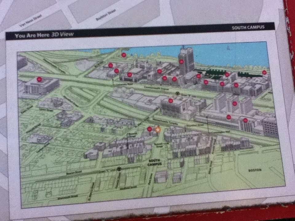


In the upper left corner is the Mass. Pike.  It goes under the intersection of Commonwealth Avenue (from the left) and the BU Bridge (from the top), both constructed on bridges.


b. BU West Station.

Green Line B runs down the middle of Commonwealth Avenue in a separated median area with traffic on both sides going in opposing directions.

On the BU Map can be seen a T designation a few blocks east of the BU Bridge / Comm. Ave. intersection.  This is next to the location of the BU West Station.  This station is unusually close to the next station to the east, the BU Central Station.

Moving the BU West Station to that point a block east of the BU Bridge would be simple.  The intersection is already controlled by street lights and crosswalks.  Relocating the station to this point would create a more logical distance between stations on the line.

This relocated station would be ideal for servicing the events slated for Magazine Beach, on the far end of the BU Bridge, not really that much of a walk.


c. Connection to Green Line B.

On Boston University’s public map of the area in the upper left corner can be seen the Massachusetts Turnpike going under the Commonwealth Avenue bridge close to the connection to the BU Bridge.

The street car spur should be run between the Mass. Pike and the Boston University Buildings south of it.

The nearest building in my photos, below, appears on this map between the Mass. Pike and Comm. Ave.


d. Connection to Commonwealth Avenue.

Here is the area where the switch should go.  The Green Line A’s bridge would run from the Commonwealth Avenue Bridge going over the side of the bridge, to the right in the photos.

First is the northern, westbound side of the Commonwealth Avenue bridge.  Green Line B is to the left.  The Mass. Pike, not seen, is to the right.  The dividing line immediately visible in the second shot is the separation between the bridge over the Mass. Pike and the bridge over Commuter Rail.  The second divider above the commuter rail in in the background.  The third picture is taken closer to the BU Bridge crossing.  Now the first divider is in the background.  The switch should go near the third picture, with the track crossing traffic and going over the side onto its own bridge at about the point where the first parked cars can be seen on the right.


e. Commonwealth Avenue to Station 1.

Here is the tightest part.  Nevertheless, there definitely is room for the Green Line A bridge.

The photos start looking up at the Commonwealth Avenue Bridge and proceed to show the area between the BU Buildings and the Mass. Pike viaduct.

The BU map shows one building between the Mass. Pike and Commonwealth Avenue.  This photograph is taken from its parking lot.  Commuter Rail is straight ahead.  There is a difference in construction between the bridge over the Commuter Rail and that over the Mass. Pike, to the left.  Green Line A should be constructed in air rights over the Commuter Rail.

.
These photos start from a little bit west of the location in the above.  They are headed west instead of east.

The commuter rail is to the right of the concrete wall.  Green Line A could easily be placed on the beam supporting the Mass. Pike.  To the extent more room is needed, there is ample air space from the BU Building.  As you go further west, the space available on the supporting beams decreases, but there is still ample room from the BU Buildings.


The point of photograph moves further west.  In the first photo, the building with the truck backed in is the closest structure to the Mass. Pike.


This is a view back to the area shown in the above sequence of photos.  It has been awhile, but my memory is that the next three photos are all taken from the roof of the building with the truck backed up.  It is easily accessible from the other side and used for parking.  At this location, there is currently one commuter rail track between the Mass. Pike and the building.  Looking at the above photo, there is a support for the Mass. Pike before and after the BU building on what appears to be BU property.  Ideally, Green Line A, ideally would be built at this point simultaneously with the Mass. Pike reconstruction and cantilevered over the space (see below) above the commuter rail track and slightly above this building.

 Green Line A would probably have to be done in part on air rights over this building.  Definitely feasible and not significantly more intrusive than the current situation.


f. Station 1, BU Housing and Athletic arena.

I am sorry I have not been able to get a copy of the Olympics plans for usage.  I have requested a URL for the plans presented at the Harvard Business School presentation without success.

Olympic plans include use of areas of Boston University which would be readily accessible from this station (and thus from Harvard Square and Kenmore Square, plus).  Ideal connections.

Connection would be directly to a plaza in the residential complex a floor above street level.  This is on the left in the photo showing the viaduct.  Another photo shows the complex and the Mass. Pike from the side street east of the complex.

The streetcar bridge would be going steadily downwards from Commonwealth Avenue to the future Harvard Medical School area.

The exact point where Green Line A would be going underground would be determined by the slope needed to drop the bridge two floors from this stop.

A few more photos.

This is Boston University's new dorm.  It would be ideal to build a station above the road and connecting with the dorm's plaza one story above the road.


This is the side street between the dorm and the building from whose roof / parking the prior photos were taken.  The Mass. Pike can be seen in the distance in the first shot.


Boston University has construction on Commonwealth Avenue visible to the right, looking in the opposite direction.  This construction includes Agganis Arena which I think (and I do not have the plans in front of me) is one of the Olympics sites.


Boston University has construction on Commonwealth Avenue visible to the right, looking in the opposite direction.  I believe the near building is part of the athletic complex.  Beyond it is Agganis Arena.  One or both are probably Olympics sites.  Beyond Agannis Arena / the dorms is Nickerson Field (formerly Braves Field of the long gone Boston Braves).  Walter Brown Arena is beyond Nickerson.  All of these sites are highly likely for the Olympics.


g. Station 1 to Station 2.

Now we are getting into the MassDOT Mass. Pike planned area / Harvard Medical School.


Daytime layover yards are being provided for South Station commuter trains around the area designated for Green Line A.  It would be ideal to have Green Line A to be underground at this point, under the relocated Mass. Pike.  Storage for South Station really should be larger than the MassDOT plans.  Storage for Green Line A vehicles should be accomplished under the South Station storage.

Before the shown turn, Green Line A should go into the ground and be constructed as a direct underground continuation of bridge structure connecting to the switch on Commonwealth Avenue.

Photos in the next section come back to this area.


h. Station 2, Harvard Medical School, etc., and surroundings.

Station 2, exact location to be determined, would be the primary station for Harvard’s Medical School and related facilities.  Connections are being created in the Mass. Pike plans for pedestrian connection to the area to the right / east, toward Commonwealth Avenue and Boston University’s westernmost holdings.

Here are some of the photos I have previously posted of this area.  Looking at the map, the buildings on the right / eastern side have a very clear demarcation.  The smaller buildings below on the map are residential housing.  The larger buildings above are mostly if not all Boston University.  There may still be some non BU ownership next to Harvard’s area.


The Olympics plans call for use of the BU area for Olympic facilities.  BU's Malvern Field and New Balance Field are on the far side of the low buildings in the first photo.  Station 2 would be ideal for these facilities.

The raised bridge in the last photo is Cambridge Street, which links not far from the viewed bridge to the River Street Bridge which is the next bridge to the west of the BU Bridge over the Charles River.


i. Station 3, North Harvard and Cambridge Street.


Cambridge Street is the Boston / Allston extension of the River Street Bridge, the  highway bridge over the Charles west of the BU Bridge.  Then comes the Western Avenue bridge, then the Anderson Bridge Connecting North Harvard Street to Harvard Square.

This station would service the neighborhood and the southern portion of Harvard’s Medical School project.  It seems highly likely that Harvard will be building housing at this end of the project.

That is why I suggested Olympic housing for this area.  Neighbors on the right / eastern side are highly concerned about highway noise.  Covering over the Mass. Pike with a portion of the residential construction would be strongly appreciated by them, and the folks on the left / western side would not be displeased.  That highway is the noisy part of the situation.

We are getting into an area for which I have few photos.  I will try to correct this defect in coming days.


j. Station 3 to Station 4.

Under North Harvard Street, housing on both sides.  It could use sound proofing, but streetcars really are quieter than automobiles, and the street cars would be replacing many automobiles.


k. Station 4, North Harvard and Franklin Streets.

Both streets are major in North Allston south of Western Avenue.  It is not unreasonable to call Franklin the real extension of North Harvard Street, but the historical situation is different.

This station would provide excellent transportation for a lot of housing in North Allston north of the Massachusetts Turnpike.  It would also not be inconvenient to Harvard’s construction on Western Avenue.  Harvard owns all of Western Avenue.  Its Business School, parking, a parking garage and affiliate housing fill the north side of Western Avenue between North Harvard Street and the Charles River.

The south side is under construction and Harvard has big plans.


l. Station 4 to Station 5.

Under North Harvard Street.

Harvard’s expansion / construction area is on both sides of North Harvard Street.  A massive project is in progress on the northwest corner of Western Avenue.

On the northeast corner of Western Avenue is the now being dismantled Charlesview affordable housing, which Harvard intends to replace with another massive project.

South of Western Avenue, North Harvard Street turns east around the Franklin Street conection.  This is the end of the area which shows to shows on the Massachusetts Department of Transportation map upon which my analysis is based.  For simplicity, here is another copy.


I cannot find my photos of the Charlesview housing, in the process of destruction.  I will get further photos of it and photos of the other project, which is at a density as great as the average Harvard Square is zoned for.


m. Station 5.  Harvard Stadium / Business School.

Station 1 should go under North Harvard Street south of the connection to the western route / the layover point on the eastern route.

This station would directly serve Olympic sites planned for the Harvard Station / B School area.  An excellent map was provided in the presentation.  I have not been able to find it on the internet, but have asked for an on line URL from the Olympics organizers, should it be available.


n. Access from North Allston, Station 5, to Harvard Square.

On the south side of the Charles River is Harvard Stadium.  It would be viable to run the line either west of Harvard Stadium under existing fields or east of Harvard Stadium under North Harvard Street which is the Boston Allston extension of the Anderson Bridge connecting North Allston / North Harvard Street to Cambridge / JFK Street.

The western route seems better.  A layover should be made west of Harvard Stadium underground at which trains coming and going could pass each other.  Some yard space for temporary storage at this point makes excellent sense.  The trains would go around the Harvard Stadium complex and go under North Harvard Street.

The alternate route would go under North Harvard Street with layover next to a field of Harvard’s east of North Harvard Street and storage under that field.

A tunnel under the Charles River would connect the park at the southwest end of JFK Street in Cambridge to the South Side of the Charles River.  Access through the park would be necessary.  From this point on until we reach the Mass. Pike viaduct, all construction is cut and cover.  The tunnel under the Charles River would be cut and cover, just cut and cover under water.  Using a single track tunnel would minimize disruption.  I think the construction of this tunnel would probably be done by temporary dams around the construction area, definitely less than ideal environmentally, but necessary.


o. Harvard Station.

Harvard Station in Harvard Square, Cambridge is across the Charles River from Harvard Stadium and the Harvard Business School, where the Olympics presentation was given.  The Red Line subway used to terminate at Harvard Station with a train yard for the heavy rail vehicles of the Red Line subway at the intersection of Memorial Drive and the Anderson Bridge crossing the Charles River.

When the line was extended to Alewife station near the Belmont and Arlington lines and near the end of the Route 2 superhighway, there was no more use for the storage yard.  It was torn up and replaced with a park, a hotel-residential complex, and Harvard’s John F. Kennedy School of Government.

The JFK School and the park abut the western side of John F. Kennedy Street which connects Harvard Square to the Anderson Bridge.

Immediately to the west of the JFK School is a walkway connecting the park to a complicated but not long street pattern and then  to Harvard Square.  West of the walkway is the Charles Hotel.  The walkway is on a supporting wall behind the JFK School.  Very visible in that wall is the unremoved tunnel which connected Harvard Station to the storage yards.

In Harvard Station, the tunnel directly abuts bus tunnels which connect bus routes to the Red Line.  The only separation between the former Red Line tunnel and the bus tunnels is one wall.

It would be simple and very inexpensive to run a Green Line street car track up that tunnel with a terminus at the busway.  The streetcars are designed to be able to change direction simply by opening up operation facilities in the last car.

The connection would be simple.


p. Restoring Magazine Beach.

Restoration is promised by the Olympics folks.  Restoration should be responsible, i.e. undo the outrage which Cambridge and its friends did through flat out lies, lies of omissions, and the continuing dirty tricks of its fake group to keep and expand the outrage.

Here are before and after photos of the invasive wall installed by Cambridge and the DCR:


Restoring responsible grass in place of the invasives Cambridge and the DCR put in place should be simple.  That would remove the need for the expensive drainage system to drain off the poisons which should not be there in the first place.

The starvation wall of invasive shrubs, of course, should not be replaced.  The lawn to the river which was promised and which exists everywhere else on the Charles River Basin should be restored, along with the very real tourist attraction which the Charles River White Geese provided at the Magazine Beach playing fields prior to their heartless abuse accomplished through flat out corruption.

Corruption, corruption, corruption, business as usual in environmental destruction on the Charles River and elsewhere from Cambridge and its friends.

Monday, March 30, 2015

Charles River: Olympics Housing and Public Transit in Boston’s Allston Neighborhood?

1. The Mass. Pike reconstruction could be coordinated with the Olympics.
2. Green Line A  Street Car line.
3. Olympic / Harvard Housing.
4. Connection to Kenmore.
5. Summary.
6. Yet another conflict with “reality” Cambridge style.


1. The Mass. Pike reconstruction could be coordinated with the Olympics.

Massachusetts’ Department of Transportation has been working on a rebuilding of I90 / Massachusetts Turnpike (Mass. Pike) on the Boston / south side of the Charles River across from Magazine Beach.

Here is one of the plans I provided MassDOT for a new streetcar line through the area connecting Boston University at the BU Bridge and Commonwealth Avenue to Harvard station in Harvard Square.  The Pike is visible from the Magazine Beach playing fields which the Olympics people want to use, destroying the starvation wall built by Cambridge / friends to starve the Charles River White Geese.


This plan would work very well with the timing of the Olympic proposal and provided needed transportation for the Olympics and for the North Allston neighborhood which is badly in need of better public transportation.

Service on the streetcar line, Green Line B could provide transportation to the Boston End of the BU Bridge.  Service could be greatly improved by construction of the Green Line A spur from there to Harvard Square.

Timing would be perfect for construction of an Olympics Village at the southern end of Harvard’s holdings which are greatly impacted by MassDOT’s planned rearrangement of the Mass. Pike.  I have posted photos of this area which is currently deserted except for the to be moved Mass. Pike.

The Mass. Pike rearrangement would be perfectly timed to create an Olympics Village on otherwise unused land with excellent streetcar connections to Harvard Square and to Boston’s Kenmore Square / Back Bay / downtown.

2. Green Line A  Street Car line.

This plan is based on MassDOT’s original diagram of the reconstruction area.  The point down triangle is almost all owned by Harvard.  The area is comparable to Boston’s Back Bay neighborhood in size.


The Charles River is at the top.  The Magazine Beach playing fields are above it on the right.  The BU Bridge is barely visible at the very top.  And the ghetto to which the Charles River White Geese are confined without food is above the BU Bridge at its left.

Boston’s Commonwealth Avenue is the wide highway parallel to the right side of Harvard triangular piece of property.

The Mass. Pike currently comes from the upper right hand corner, under Commonwealth Avenue next to my hand-drawn line with the 1 next to it.  It proceeds, with exit ramps, to the left corner of Harvard’s triangle, and then down to the bottom point.  The rearrangement would run the Mass. Pike to that bottom point by way of my letter 2 in the middle.

The portion of the Mass. Pike next to the line and the 1 is being torn down because of age and wear and being rebuilt.  That portion of the road runs close to Boston University buildings, but there is room enough between the two to insert a street car line.

That is my proposal.  Start the spur from Commonwealth Avenue at the bend in the line by inserting a switch there.  The switch is old technology.  There used to be two “Green Line” routes on this part of Commonwealth Avenue.  One ran to Brighton and Newton Corner following the straight highway to the bottom of the map.  There is a point where the north-south road gets narrower.  The name changes from Commonwealth Avenue to Brighton Avenue at this point and the wider road, Commonwealth Avenue, turns to the right.

The full length of the straight road contained “Green Line A”.  At the bend, “Green Line B” turned with Commonwealth Avenue.  Green Line B leaves Green Line A by a switch at the turning point which would be identical to one used to run a new Green Line A between the Mass. Pike and Boston University.

The number 1 indicates a stop behind Boston University’s new residential / athletic complex.  My proposal would have the streetcar line turn where you see the dashed lines.  Commonwealth Avenue is on a bridge above the Mass. Pike.  The street car line would be constructed on a gradually lowered bridge from Commonwealth Avenue, reaching ground near the point where the line turns and proceeding underground from there to Harvard Square.

Point 2 is intended to indicate a stop for Harvard’s Medical School.  Point 3 is a stop at North Harvard and Cambridge Streets.  Point 4 is a stop at North Harvard and Franklin Streets.  There would be a 5th stop at Harvard Business School / Harvard Stadium, to the left of the area shown on the map.

The spur would go under the Charles River and connect to an EXISTING TUNNEL adjacent to existing underground bus tunnels which are part of Harvard Station.  The existing tunnel originally connected the Red Line to a storage yard under what is now JFK Park, Harvard’s JFK School, and the Charles Center hotel / condo complex.

The area between the turn and station 3 is not exact and would vary depending on MassDOT plans.

To the right of the streetcar spur, at the point of the turn between station 1 and 2, there are dashed lines.  These currently, roughly correspond to a storage yard intended for layover of passenger trains servicing Boston’s South Station.  The street car line at this point roughly corresponds to the relocated Mass. Pike, which should ideally be above the street car line.  To the left of the Mass. Pike should be further storage for South Station and storage for the streetcar line.  Smart planning would put one underground and the other above it.

Stations 3 and 4 under North Harvard Street would provide badly needed service for the Allston neighborhood.  Station 4, additionally, would service Harvard’s planned development on Western Avenue which is off the map to the left.

An additional smaller street car yard should be placed near station 5 to correspond to a layover place for street cars before going under the Charles River, since the very end could only be one track.  The yard would allow for temporary layovers of other vehicles between runs as well.

3. Olympic / Harvard Housing.

Harvard needs housing for its existing students in addition to housing for students in the relocated Harvard Medical School campus.


The lower point of the Harvard triangle would be ideal for the housing.  The neighbors are highly desirous of burying the railroad and highway.  Both would go under Cambridge Street at the bottom point of the triangle.  Construction in the triangle’s base connecting housing to Cambridge Street would be ideal at this point, either actual housing or a plaza.  Either could be located on top of the transportation uses.  Residential construction would be ideal for the lower part of the triangle with Harvard’s Medical School, etc. in the portion nearer to the Charles River and nearer to Harvard’s ownership on Western Avenue and between Western Avenue and Cambridge Street.

The residential construction would be a welcome improvement for Allston residents on neighboring streets on both sides of the project and would be convenient to Boston’s Allston Village shopping area.

4. Connection to Kenmore.

Here is a Boston University public map showing the area to the east of the area shown above.


The left top corner is the eastern extension of the area we have been discussing.

On this map, you can see the Mass. Pike coming from the upper left.  Coming from the left is Commonwealth Avenue.  Coming from the top is the BU Bridge.

Slightly to the left of the Commonwealth Avenue / BU Bridge intersection, the Mass. Pike "viaduct" becomes a highway constructed with direct ground support.  The "viaduct" is the portion of the Mass. Pike being rebuilt.

One Boston University building can be seen on the left between Commonwealth Avenue and the Mass. Pike.  The Green Line A spur would go between the two.

The switch for Green Line A would be located to the left of the BU Bridge on the Commonwealth Avenue Bridge above the Mass. Pike.  It would go off the Commonwealth Avenue bridge above the Mass. Pike on its own bridge and run between the rebuilt Mass. Pike and the BU Buildings.

The existing Green Line B in the middle of Commonwealth Avenue would be used to join Green Lines C and D at Kenmore Station in Kenmore Square to the right of this map.

There is a Green Line B station at the letter T several blocks east of the switch for Green Line A.  This station is very close to another station servicing this part of Boston University.  It could readily be moved so that it is one block east of the BU Bridge where it would provide excellent service for Magazine Beach on the other end of the BU Bridge, and really would provide a better location for service for everybody than the existing location.

The existing lights at the neighboring intersection should be adjusted accordingly.

5. Summary.

Green Line A and Olympics Village at Harvard Medical School would work very nicely.

Harvard is in the habit of having other folks pay for many of its capital projects.  The housing proposal works so well, I will be amazed if it is not already part of the plans.

Harvard proposes to service its Medical School by a spur off the Red Line in Harvard Square which would start one stop outbound from Harvard Station and destroy the existing, very large, passenger lobby of Harvard Station.

This proposal would be “deep bore” construction as opposed to “cut and cover” by which Green Line A would be built.

The difference in cost would be a very large magnitude of difference.

Harvard’s proposal would only stop at the new Harvard Medical School and then at a tunnel which would have buses to transfer to Harvard’s continuing Longwood Hospital Area, where the Medical School is currently located.  This would provide the medical students their very expensive shuttle train from the school to the hospitals..

My Green Line A would temporarily transfer to buses at Kenmore Station.  It would be and could be built decades before Harvard’s Red Line spur is dreamed of.  Green Line A could be ready for the Olympics.

The long run reality for Harvard medical students and the Harvard / Longwood Medical Area is a phase 1 Heavy Rail Orange Line Spur.  The full spur would run out of the Orange Line at Ruggles Station to the Longwood Medical Area at Louis Pasteur and Longwood and then running to Kenmore through what has been described at the Urban Ring subway line, Kenmore Crossing.


6. Yet another conflict with “reality” Cambridge style.

The Kenmore Crossing is the almost certain alternate Charles River crossing to be used for the Urban Ring subway which has been discussed connecting the Orange Line in Charlestown to the Green Line at Lechmere to the Red Line at Kendall to Green Lines B, C and D, to the Harvard / Longwood Medical Area to the Orange Line at Ruggles.

I first proposed the Kenmore Crossing in 1986.  It was adopted as a formal alternative by the Massachusetts Bay Transportation Authority in 1991.

A different crossing, the BU Bridge crossing, was first considered but an excellent reconstruction and expansion of the Kenmore Station on the Kenmore Crossing alternative has essentially been subsidized by the legislature by funds for expansion of Yawkey Commuter Rail Station.  Under the Urban Ring Kenmore Crossing, Yawkey Station would connect to Kenmore with an Urban Ring station above the Mass. Pike under Brookline Ave. providing the connection.

Cambridge wants the environmentally destructive BU Bridge crossing which would only work if Yawkey Station were moved.  That seems unlikely given the moneys expended by the state to upgrade Yawkey Station in place.

Last I heard, Cambridge was still lying that the Kenmore Crossing alternative does not exist, more than twenty years after the Kenmore Crossing was adopted by the MBTA as a formal alternative.

But meaningful analysis of Urban Ring phase 1 are a much longer explanation.  Links to the explanation are on the main page of this blog.

Green Line A would provide transportation for the Olympics, save a lot of money, and get done faster.  It would coordinate very nicely with the winning Kenmore Crossing Urban Ring subway alternative.  The Orange Line spur aspect would provide direct heavy rail connection to the Longwood Medical Area and Kenmore from downtown Boston, reducing pressure on the streetcar service in the Back Bay.

If Cambridge persists with the lie of the nonexistence of the Kenmore Crossing alternative, I wonder how long the lie will continue.  There are a lot of people in Cambridge, including folks claiming to represent the Sierra Club who still seem to believe that lie, a lie which is believed by no one clean of the filth in Cambridge.  Nevertheless, this lie is one of quite a few lies which pass as truth by folks impacted by the City of Cambridge.

It should be emphasized that this Urban Ring phase 1 concept is very much long term analysis.  Green Line A should be constructed for the Olympics.  Urban Ring phase 1 and the actual relocation of Harvard Medical School are very much long term.  Harvard lives and plans in Centuries.

Nevertheless, an Olympic village at the bottom tip of the Harvard triangle would have tremendous value, with Green Line A, for the Olympics, for the neighborhood and other Harvard neighbors, and for short term (less than Centuries) Harvard residential planning.  Interim use for rental purposes until Harvard needs the facilities for its own students would not be at all surprising.

Friday, March 27, 2015

Can the Olympics save the Charles River from Cambridge and its friends?

Can the Olympics save the Charles River from Cambridge and its friends?

1. Starvation Wall.
a. Plans.
b. Past experience.
c. Flat out lies to achieve.
2. Other impacts on the Magazine Beach playing fields by Cambridge / accomplices, possible results.
a. Introduction of invasive vegetation by Cambridge, etc.
b. Destruction of playing fields.
c. Will the bleachers need room taken up by the drainage system?
d. Fake group activities.
3. What other destruction?
a. Hostile to animals.
b. Company union fight for all destructive activities of Cambridge and its friends.
4. Lies, lies, lies.  This has to be Cambridge and its friends.
5. So what other lies are the Cambridge City Council / friends coming up with to yell at people who are not as vile as Cambridge and its friends?


1. Starvation Wall.

a. Plans.

The one thing which is clear about the Olympics planning on the Charles River is that they want to destroy the starvation wall.

Before:


After:


b. Past experience.

The one event in the past which compares to the Olympics was the Charles River Regatta.

The Charles River Regatta took over the Magazine Beach playing fields for a weekend each year.  It disrupted the Charles River White Geese in that they, for the weekend, could not get to their food and their resting place at the Magazine Beach playing fields, where they lived and were a loved tourist attraction most of the year for most of the last 34 years.  But they did often sleep in the Charles River off the playing fields.

There was no harm whatsoever to their back up residence east of the BU Bridge, where they are now confined without food.

Definitely better than Cambridge and its vile friends.

c. Flat out lies to achieve.

The Cambridge City Council has claimed lack of openness by the Olympics.

This bizarre claim is the typical rottenness of the Cambridge City Council.

There were three flat out lies, at minimum, in Cambridge/friends’ construction of that starvation wall.

(1) A lawn to the river.

That was the promise in the vile bureaucrats “Charles River Master Plan.”

So they modified the Master Plan after the destructive wall was built to turn a lie into a former lie.

(2) Repeated promises over many years to do “no harm.”

This came from the horribly lying key manager.

He repeatedly promised to do no harm to the Charles River White Geese.

When Cambridge / its friends started the starvation, the Boston Globe led one of its Sunday sections with a photo of a tiny white goose overwhelmed by a construction machine.  To the right of the massive photo was a quote from this massive liar, promising to do no harm.

Here is a photo of friends of the Charles River White Geese feeding them over the wall that these vile people put up.


(3) Cheerleader activity.

The falsely named Charles River “Conservancy” conducted a swim in to celebrate the starvation attack.

All action, no matter how vile, is claimed to improve swimming.

This vile organization has yet to explain how walling off the Charles River from the playing fields aids swimming from the playing fields.

But then, when caught in lies, these vile groups just resume other lies or whatever else will work.

2. Other impacts on the Magazine Beach playing fields by Cambridge / accomplices, possible results.

a. Introduction of invasive vegetation by Cambridge, etc.

The Olympics organizers plan to put in temporary stands.

The temporary stands could be impacted by another part of the vileness of Cambridge and its friends.

Cambridge and its friends destroyed healthy grass on which the Charles River White Geese fed for most of the last 34 years and replaced it with sickly stuff which requires poisons to survive.

Introduced vegetation which requires poisons to survive is clearly destructive to the environment.  The only reasonable definition is that INVASIVE VEGETATION was introduced as part of the sick destruction on the Magazine Beach playing fields.

b. Destruction of playing fields.

To keep the bizarre poisons out of the Charles River, Cambridge, etc. created an expensive drainage system.

That expensive drainage system replaced playing fields.  One of the key lies in the outrage was “improvement” of playing fields.

c. Will the bleachers need room taken up by the drainage system?

I certainly hope so.  That would require stopping the poisons to keep alive the sickly invasive introduced grass.  The responsible thing to do would be to seed the responsible grasses destroyed by Cambridge, etc.  You know, the stuff that did not require poisons.

d. Fake group activities.

The fake group fighting for destruction of the Charles put their outrages up to a public meeting in January 2014.  They want to expand the invasive grasses and poisons to the top of the hill to the west of the playing fields and to the wetland west of that behind the swimming pool.

They want to destroy the little guys’ parking lot at the top of the hill, and at the end of Magazine Beach.


They also want a new highway which is related to the massive tree destruction.

And keep the outrages in place on the playing fields.

They did good publicity and got a good attendance.  The good attendance were normal human beings, hostile to the vile plans.

So the fake group deferred the vote until their February meeting which they conducted on April 23, this time with no publicity.

They deferred discussion of this topic, which took the entire January meeting, to the last ten minutes.  At that time, they introduced a horribly complicated motion and ordered that it be fully discussed in ten minutes.  And then voted on by folks who could care less.

They since replaced monthly meeting with bi-monthly meetings cancelled in the summer and cancelled twice since then.  They have severely abused the agenda to prevent meaningful discussion of the Charles River by splitting announcements.  Most announcements go at the beginning.  Charles River goes at the last ten minutes, and reality is censored by lack of time.  They have also introduced exercises in the middle of the meeting which helps reduce the time available for reality which, in reality, is censored by “lack of time”.

The only time they conducted this announcement in the middle of the meeting, they simply shouted down responsible discussion.

And the Cambridge City Council piously yells at the Olympics folks.

This kind of corruption is normal from the fake groups in the City of Cambridge.

And two of the worst destroyers in the fake group are being presented by Cambridge/its friends as defenders of the Charles River.

3. What other destruction?

a. Hostile to animals.

Well, of course, they now brag about hostility to the animals of our world.


This replaces more than a decade of lies of “no intent” to harm.

A sign from their propaganda piece in the second most important Cambridge public building.


b. Company union fight for all destructive activities of Cambridge and its friends.

The fake group lives by the company union tactic of lying of concern and then telling folks to ignore everything of value.

They are thus fighting for all vileness on the Charles River being sought by Cambridge and its friends.

That includes the destruction of hundreds of trees between the BU and Longfellow Bridges supported by the State House in the amount of $20 million last year.

Chapter 286 of the acts of 2014, “historical parkways”

Among other things, the Cambridge City Council, while lying of no involvement in the Charles, has destruction proposed for the Charles and its animals through new construction and construction of a fence splitting the animal area in two

And their friends have been busy on the Boston side seeking to extend their construction to that side of the river as part of the Mass. Pike (I90) reconstruction.


The Massachusetts Department of Transportation is not perfect, but this is another example of it standing up to Cambridge outrages.

So the Cambridge City Council authorized negotiations with Boston to work around this responsible bureaucracy.

4. Lies, lies, lies.  This has to be Cambridge and its friends.

Two of the most visible of the destroyers are now being presented as defenders of the Charles River by Cambridge and its frieds.

5. So what other lies are the Cambridge City Council / friends coming up with to yell at people who are not as vile as Cambridge and its friends?

Stay tuned.  They are very innovative.

Sunday, March 22, 2015

Charles River, MA, USA: More Olympics hypocrisy: Cambridge City Council

1. Cambridge Day report.
2. Reality.
3. Cambridge’s development department is consulted on all environmental destruction.
4. A few examples.
a. The Longfellow Bridge project.
b. Use of fake groups.
c. Alewife.
d. Secret definitions.
e. Fresh Pond.
f. Cambridge Common.
g. Street trees.
3. Summary.

1. Cambridge Day report.

The on line Cambridge Day reported in its March 19, 2015 report on the March 18, 2015 gathering in Cambridge organized by the committee working to bring the Olympics to Boston / Cambridge in 2024:

Last month the City Council adopted a policy order denouncing the
      organization for acting “without meaningful public input or any real
      community engagement.”

2. Reality.


The poor dears from the Cambridge City Council, talking oh, so piously about “without meaningful public input or any real community engagement.”

The use of fake groups and other techniques to achieve environmental destruction is the norm in Cambridge.

Cambridge lives by the developer logo: “getting things done” by whatever technique “works” is the norm, combined with declaring to be holy than thou city councilors and pols in the middle of the destruction.

We had a very interesting “event” as people were going into the March 18, 2015, gathering.  I was leafleting folks, objecting to the environmental destructiveness of the Cambridge City Council and its accomplices, especially on the Charles River, the heart of the Olympics in Cambridge.

Nevertheless, every councilor I approached accepted a flier, with one exception.  She has been on the destructive side on the Charles River outrages from the very beginning

Fliers are a major part of the expenditures of Friends of the White Geese.  Our expenditures are very heavily targeted on communicating the destructiveness of Cambridge and its accomplices.  Please remember, there is a button on this blog to make contributions to Friends of the White Geese.  Contributions are badly needed, especially for the various modes of communication.  There is only one organization that I know of which is MEANINGFULLY defending the environment in the political arena, on the Charles River and elsewhere impacted by the very destructive City of Cambridge.  We accept PayPal which, as near as I can gather, translates into most any credit card or direct payment from a bank account.

We created the Charles River Urban Wild Initiative to have a separate, non political entity for feeding the deliberately starved animals.  CRUWI is very strongly non political.  Thus the existence of and very strong separation of the two entities keep funds for each purpose totally separate.

O.K., let’s go into part of the outrages.


3. Cambridge’s development department is consulted on all environmental destruction by the bureaucrats involved.

The agencies really hesitate to destroy
 without the Development Department's concurrence.

The City Council has a right to fire for cause the Cambridge City Manager.  The very terrible nature of the Cambridge Development Department is certainly not as strong a cause to fire as was the Monteiro outrage, but it is adequate.  The reality is the Cambridge City Manager really implements the wishes of the Cambridge City Council.

That motion I reported a couple of days ago to destroy on the Cambridge Common as fast as possible is an excellent example of reality in the City of Cambridge.

I will go into the Monteiro outrage at the end of the hit list, for the uninitiated, rather than drive people away with more words.

4. A few examples.

a. The Longfellow Bridge project.

Here are a few photos of that destruction from this blog.

Before:


After:


One of the nicest things during the Olympics leafleting was a gentleman who noticed this totally useless waste of excellent trees.  With more money, we could possibly save more things.  That grove and its neighboring trees were some of them.

Other threatened / destroyed trees:


Note the orange dot, the mark of death to come.

Caveat:  I in the past, I have confused the photos of tree destruction at the Longfellow Bridge with that on the Cambridge Common.  The Longfellow Bridge photos are from a very concerned friend who I know provided individual photos.  I think the last three photos are Longfellow Bridge.  Please advise if I am in error.

b. Use of fake groups.

This dates back to the return of Cambridge City Manager James Leo Sullivan in 1974.  He had been fired in the mid 60s by the Cambridge City Council and was not interested in it happening again.

One of his big goals was the creation of “neighborhood associations.”

I recall a discussion with a former Cantabridgian who told me he was creating a neighborhood association in the West Roxbury neighborhood of Boston.  I told him we did not have to worry about that in Cambridge.  Friends of the Cambridge City Manager do that for us.

We shared a laugh at that.

The stench of these fake groups is outrageous.  Through various techniques over the 40 plus years since then, Sullivan and his two offspring, Healy and What’s-his-name, have developed a strangle hold on Cambridge politics.  That includes a strangle hold over the Cambridge City Council.  And a strangle hold on the environment of the Charles River and all else within the touch of this vile city government.

The fake groups are the reason why Cambridge is a threat to the environment of the entire area surrounding the City of Cambridge.  They keep a vile City Council in power, lying that that vile city government is holier than thou.

c. Alewife.

The fake group “defending” Alewife has been a fraud from the beginning.

Fighting private developers obeying zoning while

(1). Telling people to keep away from the Cambridge City Council and other municipal entities which control the zoning;

(2). Telling people to ignore the publicly owned properties which are the easy wins, if the Cambridge City Council’s “concerns” are other than flat out lies.

The Cambridge City Council has indulged in multiple frauds yelling at private developers obeying zoning while failing to place crucial and massive flood storage protections under all new area projects through takings or otherwise.  The fake group’s leader bragged about Cambridge’s destruction of 3.4 plus acres behind 165 CambridgePark Drive.  A least one fraudulent “environmental” group gave her a podium to brag about destruction that that group had claimed to oppose.


This is a City of Cambridge puff piece photo.  The trees in the background used to fill the entire area.

d. Secret definitions.

“Environmentalism” as used in the City of Cambridge by ALL visible groups except Friends of the White Geese translates as defending that part of the environment NOT being destroyed by Cambridge / its friends.

e. Fresh Pond.

A massive project beautifying animal habitat.

Animals are so inconsiderate of human tastes.  Animals want to live.  Humans who yell want gardens.

This is how humans are destroying our world.

f. Cambridge Common.

A minimum of 22 excellent trees being destroyed with state moneys.

The city council just yelled at the Cambridge City Manager to destroy, destroy, destroy.


g. Street trees.

One of the few parts of the vileness the Machine dignifies, because it cannot be hidden.

Excellent trees are routinely destroyed for replacement with saplings.

There are a few reasons.  One is that contractors get paid to destroy trees and contractors get paid to plant saplings.  Welfare for contractors.

A second is sick manipulation of the Tree City award.

Tree City rewards planting of trees.  Excellent, mature trees are in the way of saplings.

Cambridge, in its sick mentality, gets no political benefit from mature, excellent trees.  Cambridge gets plenty of benefit from planting saplings to replace excellent trees which should not be destroyed.

This destruction is from the Mid-Cambridge area, Chatham and Dana Streets.  My photos, notice by a concerned neighbor.


f. Charles River.

The principal purpose of this blog.  See so many reports.


g. More, more, more.

I have fought this outrage for 40 years.  I have many victories.

James Leo Sullivan, at his return, was clearly highly offended by the realities of the government of the City of Cambridge.

Robert Healy was fired along with James Leo Sullivan in the 60s.  By the time he retired with honor, he and James Leo had created and put into place a government which clearly proved the vileness which is the reality behind political control in the City of Cambridge.

h. Monteiro.

Malvina Monteiro is a black, Cape Verdean woman who was head of the Cambridge Police Review Board.

She made a very serious mistake, comparable to the mistake of the voters keeping a vile City Council in office.

She believed the lovely words from the folks keeping that vile City Council in office.

The voters have almost certainly removed one guilty city councilor and probably a second as a result of this outrage.

Monteiro filed a civil rights complaint alleging that women are discriminated against in their pay by the City of Cambridge based on their gender.

According to Superior Court Jury, Superior Court Judge and Appeals Court reviewing panel, the Cambridge City Manager destroyed her life in retaliation for her filing that complaint.

The cost of this outrage amounted to the following:

(a) Compensatory Damages:                                                                            $1,062,400.00
pre-judgment statutory interest of twelve percent (12%) per annum               $438,003.70                        from January 5, 2005 until June 12, 2008
post-judgment statutory interest of twelve percent (12%) per annum on the compensatory                        damages as well as the accumulated pre-judgment interest ($1,500,403.70)       $350,727.57                   from June 12, 2008 until May 24, 2010;
(b)  punitive damages                                                                                     $3,500,000.00
         post-judgment simple interest of twelve percent (12%) per annum                        $81,814.41  
                  June 12, 2008 until May 24, 2010
c reasonable attorneys' fees                                                                            $545,842.00
costs                                                                                                                $23,697.00
                                                                                                            $6,002,484.68
Payment

$8,300,000.00    Check.

Outside Council

1998 complaint to 2008 trial                                             $2,144,000.00  
        CM to Finance Committee, 6/12/12

        Appeals                                                                             $488,409.00  
        CM to Finance Committee, 6/12/12

Sum of payment to Monteiro, Plus Outside Council                     $10,932,409.00

Total paid in the five cases, Cambridge Day, 6/21/12.

City Solicitor letter, 6/12/12.                                            $14,569,558.00

Appellate fees and costs for plaintiff.  App Ct.,
        MLW 10/22/12, p. 20, App. Ct. Docket 2010-P-1260, 10/10/12 $298,349.33


Exactly zero members of the sitting City Council had any use for the repeated communications from jury, judge and appeals court panel which gave them full power to fire City Manager Robert Healy for malfeasance in office.

This action combined with the environmental outrages puts the lie to the holier than thou claims of those who really control the City of Cambridge, MA, USA.

3. Summary.

James Leo Sullivan, through his successors, has proven just how vile the situation in Cambridge, MA truly is.  He was not pleased with the 60s firing.  Cambridge’s destructive impact extends into regional / state bodies.