Thursday, October 08, 2015

A bad Cambridge City Council in real trouble?

A bad Cambridge City Council in real trouble?

1. Introduction.
2. Analysis.
a. Cambridge Common.
b. Outrageous zoning vote in Central Square.
c. Actions to destroy the zoning ordinance.
d. Charles River, Alewife, and other.
e. Monteiro.
f. “Unity” Slate.
g. The stench.
3. Summary.
4. Caveat.


1. Introduction.

Tuesday night, October 6, I was outside a candidate’s night conducted in the Senior Center across from Cambridge City Hall.

It was a very unusual experience.

This was a gathering sponsored by a Ward 6 group in which folks were given an opportunity to see City Council candidates in person answering questions.

These gatherings in this location, over many years of observation, are always notable by large numbers of candidate workers lining both sides of Massachusetts Avenue bearing signs to promote the candidacy of their favorite.

It has not been unusual for the workers to fill the block of Massachusetts Avenue in front of City Hall and to fill much of the block around the Senior Center.

Tuesday night, there were seven workers.  Five (or was it four?) of the seven were working for Minka vanBeuzekom.  Two (or one) of the workers were there for another candidate.

This sort of a terrible turnout is unheard of in my experience.  I do recall the candidate with one or two workers coming out of the meeting and looking bewildered, apparently at the situation.

A candidate’s night for East Cambridge on Wednesday evening showed six workers from a different candidate.

2. Analysis.

It is mild to say this bad worker turn out speaks badly for the candidates, particularly the incumbents.  Incumbents normally really turn out folks.

a. Cambridge Common.

It gets worse when you take into account my clearly hearable exchange with one of the Minka workers.  Minka vonBeuzekom is a one term city councilor who failed reelection in the last election.  Her performance is the reason I am insistent that Cambridge has ten city councilors (out of nine) to blame for the destruction of the Cambridge Common.

I asked the worker why Minka has a green leaf on her campaign sign.  (Quotes approximate.)

“Because she is an environmentalist.”  He said proudly.

“But she destroyed the Cambridge Common.”

“That can’t be.  You must have something wrong.”

“She voted for the funds. [pause] She explained her vote by saying the Development Department said it was OK.”

End of discussion.  A definite pall over the workers.  They left after the candidate session was apparently filled with participants.  I offered a leaflet to the last one remaining after the others were gone.  It was dispiritedly declined.

The nine current incumbents all have filthy hands.  The destruction of the Cambridge Common happened on their watch, plus they had a unanimous vote several weeks before the start of destruction concerning the project.  The city council in that vote wondered why the destruction was not going forward (They ALWAYS use euphemisms).

The destruction of the Cambridge Common is a very major issue and a major cause for distress concerning and for reconsideration of all ten of the guilty city councilors, among aware voters.

b. Outrageous zoning vote in Central Square.

Additionally, the Cambridge City Council (and there may have been some negatives) changed the zoning in Central Square to allow ONE new building perhaps 50% higher than any other building in Central Square, including the very few really tall buildings.  Restricting building height is a matter of great concern to Cambridge voters.

This is a matter in which the usual suspects created the usual fake group to control local “activists.”  The “protective” group, predictably, achieved yet another loss.

Losses or even achievement of the opposite of stated goals are not surprising when observing in such groups.  I have a lot of zoning / environmental victories.  I learned very early to keep out the usual suspects.  When the usual suspects get involved, bad things too often have happened.

The manipulation of the “activists” is something most people would not understand.

The very unattractive vote is something a lot of concerned people would understand and could get very hostile about.

c. Actions to destroy the zoning ordinance.

This is something which most people would not understand, and if they are talking to one of the controlled “activists” would get exactly the wrong impression about.

Nevertheless, there are a number of city councilors working to destroy the zoning ordinance through a manipulation called a “Master Plan.”

This con game translates into giving appointees of the Cambridge City Manager the power to trash the zoning ordinance at will.  The trashing would be based on provisions of a “Master Plan” which quite certainly will be beyond the comprehension of the average person, but which will be very destructive to the existing zoning ordinance without the victims having any knowledge or understanding of what has been done to them.

Once again, not something the average human is going to understand, but very real.

d. Charles River, Alewife, and other.

I have gone into these repeatedly, including the Charles River and Alewife, but not just on the Charles River and Alewife.  

The reality is there is a stench and bad faith, to put it mildly, is in the middle of a very significant percentage of city actions which count.  The stench, in particular, surrounds too many groups which claim to be protecting the city but which in reality are clearly cheerleaders for a bad city government.

e. Monteiro.

Malvina Monteiro was the head of the City of Cambridge’s police review board.  She is a black Cape Verdean woman.  She made the mistake of listening to the self deification of so many members of the political establishment.

Monteiro filed a civil rights complaint alleging unfair treatment by the City of Cambridge based on her gender.

The City Manager destroyed her life in retaliation.

The jury awarded $1.1 million in real damages and $3.5 million in penal damages.

The judge issued an opinion which quoted the City Manager extensively.  She referred to his behavior as “reprehensible.”

The appeals court panel refused to dignify Cambridge’s appeal with a formal opinion.  The opinion which they did not call an opinion spoke of “ample evidence of . . . outrageous behavior.”

Total costs to the City of Cambridge in Monteiro and related cases exceeded $14 million.

The City Solicitor fairly promptly “retired”

The City Manager, who had been roundly condemned by three levels of court, retired after a reasonable period with praise.  The City Council named the Police Station after him.

In the first city council election after that outrage, one councilor almost certainly was fired as a result.  He called destruction of Monteiro’s life no big thing in one of those election candidate sessions.

In the second city council election after the Monteiro outrage, a second councilor could very likely have been fired as a result.

The councilor I saw looking outside the candidate presentations room at the near empty sidewalk which contained one or two workers for that councilor could very possibly still be threatened by voter retaliation.

f. “Unity” Slate.

In front of Tuesday’s gathering, one of the sign posts in the minority included a photo of all seven current incumbents on a slate they call the “Unity” Slate.

The pitch is that they work together well and thus that they endorse each other.

In the past, Cambridge used to have two competing slates during elections.  They were, respectively, pro and anti rent control.  The slates were ideologically strong and highly competitive.  The two groupings, during the year, kept a close eye on each other, and their supporters publicized alleged wrong doing as they saw it.

Since the death of rent control, policy differences among incumbents have drastically disappeared.  Really terrible votes see unanimous or near unanimous support.  My experience is that, on a lot of really bad actions in the development field, there are often two explanations for the actions.  One explanation goes to the well intended voters.  The other explanation is the one held by those in the know.

Support for environmental destruction is commonly unanimous.  Support for outrageous action in the Monteiro matter was commonly unanimous or near unanimous.  I very seriously doubt (although I have not checked) that there was meaningful opposition to naming the Police Station after that City Manager whose destruction of Monteiro’s life was so roundly condemned by three levels of Court.

I am quite certain that NO then sitting member of the then Cambridge City Council, in any way, supported firing the then sitting City Manager after those decisions in Monteiro.  This was in spite of the very clear fact that the decisions gave them a free pass to fire the Cambridge City Manager without fear of meaningful legal suit.  The big issue would have been whether they could have stripped him of his pension rights.

The “Unity” Slate and those photos, plus the striking record on bad actions give an reasonable impression that almost all of the Cambridge City Council is ganging up on the voters.

g. The stench.

Folks will not see much if at all anything of these analyses and the analyses probably would be way out of comprehension to most of them.

But there is a very real stench.

3. Summary.

I know very little about many of the challengers.  I know too much about ten present or former city councilors seeking reelection and not being worthy of it.

The incumbents normally dominate the workers on the sidewalks.  There may have been 7 workers on those sidewalks on Tuesday when I normally expected to see perhaps hundreds.  And I may have chased away one or more of Minka’s five.

I was very pleased to see that bad turn out of workers.

4. Caveat.

The unusual system of voting in the City of Cambridge has an unusual side effect.  Voter’s vote, numerically, in order of preference among the entire slate of candidates.  During the count of votes, votes get “transferred” to lower preference numbers on respective ballots as candidates get elected or lose, and thus no longer “need” the votes because they are either in or out.

I have seen councilors who looked in serious trouble roundly reelected, probably because their names get moved up the individual preference lists based on need.

I recall at least one councilor who looked like a sure thing losing, clearly because a lot of people moved that councilor down their list of priorities because that councilor did not “need” the vote.

Wednesday, October 07, 2015

Charles River: Photos, CURRENT Memorial Drive Construction Zone and Major Likely Victims

1. Introduction.
2. Photos.
a. East of the “protection” zone.
b. The Wild Area.
c. BU Bridge / Destroyed Nesting Area.
3. Past Reports in THIS series, and a communication showing everything to a bad city council.


1. Introduction.

Report 4 in a series.

A few days ago, the local fake group fighting for destruction on the Charles River in Cambridge, MA, hosted a feel good public input presentation of the destructive Department of Conservation and Recreation concerning part of the Charles River.

It developed that the DCR has set up a construction zone in SECRET up the highway that looks like it is the preparation for the destruction of hundreds of trees in accordance with a vote of $20 million by the State House.

In this report I will present photos of the most outrageous likely subjects for destruction.

The overall plans of the DCR as I presented them to the Cambridge City Council are posted at http://charlesriverwhitegeeseblog.blogspot.com/2014/04/tree-destruction-plans-charles-river.html.

I am thinking over the value of conscientiously doing a tree by tree analysis because individual analysis cannot meaningfully communicate the vileness of the package.  The scope is simply too large.  The plans combined with the most outrageous individual actions may help.

2. Photos.

a. East of the “protection” zone.

Here are the plans for destruction in the area just east of the protected area.


These plans view excellently with a double click.  Fowler Street, at the top of the second plan, and the marked trees below it are the end of the protection area as of yesterday, October 7.

The row of doomed trees below and to the left of Fowler Street are the easternmost extent of the apparently doomed grove.

Here are photos I took on Monday of this area.  I understand these are Cherry trees.  I have previously counted the grove as 105 trees, with about 81 slated for destruction.

Please compare as you see fit to the destruction plans.

The first photos are of the portion shown on the second plan, taken walking away from the protect zone.


Here are earlier photos taken from inside and from the opposite direction.

They were taken in September 2011, so the trees as shown above give a much better communication of size.


b. The Wild Area.

Here is the woods between the Grand Junction railroad bridge and the BU Boathouse.  ALL BUT 1 TREE seems to be slated for destruction, along with mass removal of earth and the creation of a supporting wall under the highway sidewalk.


c. BU Bridge / Destroyed Nesting Area.

To the west of the Grand Junction railroad / bridge is the Destroyed Nesting Area where the Charles River White Geese have been confined without food, barred from their home of most of the last 34 years by a bizarre introduced wall built, of course, in secret.  The fake public meeting included an expression of intent to trim the wall but keep it for starvation purposes.

This excellent tree looms over the Destroyed Nesting Area.  It, is a dominant view at the intersection of the BU Bridge and the Memorial Drive on ramp.   It is among the doomed.


3. Past Reports in THIS series, and a communication showing everything to a bad city council.

a. DCR Destruction Plans as provided to Cambridge City Council by me on April 1, 2014, full publication of plans in post: http://charlesriverwhitegeeseblog.blogspot.com/2014/04/tree-destruction-plans-charles-river.html.

b. Report 1.  Charles River:  Massive Tree Destruction Appears Imminent on Memorial Drive, October 4, 2015.  http://charlesriverwhitegeeseblog.blogspot.com/2015/10/charles-river-massive-tree-destruction.html.

c. Report 2.  Memorial Drive Plans and Photos, October 5, 2015 http://charlesriverwhitegeeseblog.blogspot.com/2015/10/charles-river-memorial-drive-logging.html

d. Report 3. Charles River: CURRENT Memorial Drive Construction Zone, October 6, 2015, http://charlesriverwhitegeeseblog.blogspot.com/2015/10/charles-river-photos-current-memorial.html

Tuesday, October 06, 2015

Charles River: CURRENT Memorial Drive Construction Zone

Charles River: CURRENT Memorial Drive Construction Zone


Report 3 in a series.

1. Introduction.
2. First stages?
3. Preliminary photos.
4. Previously condemned trees protected?
5. Summary.
6. Past Reports in THIS series, and a communication showing everything to a bad city council.


1. Introduction.

The topic of this series has been repeatedly presented by this blog.  It has consistently been censored by Cambridge cheerleading groups, by entities in the City of Cambridge, and by their accomplices in their very terrible cause.

This is the third report in THIS series.  Prior reports in this series, with URLs are provided in the last section.

2. First stages?

The Department of Conservation and Recreation has set up a construction zone which, SO FAR, runs from Endocott Street to Fowler Street.  These are the first two streets east of the point where Memorial Drive splits.

Here again are the DCR destruction plans for this and adjacent areas.  This is a tiny fraction of the plans provided in the link in the last section.

DOUBLE CLICK on the plans.  The result is striking.  The BLACK CIRCLES are condemned trees.


3. Preliminary photos.

It is very much impossible to give the vileness probably involved the detail it deserves at such an early stage of construction.

All of the median between Fowler and Endicott Street has clearly been established as a construction zone by putting in TWO LARGE construction management trailers just west of Endicott Street and by constructing protection on all trees between the trailers and Fowler Street.

Here are photos of the trailers.


More importantly, here is a pile of wood strips clearly intended to expand the construction zone.


Here are some photos of protected trees from October 5, 2015.  These protected trees amount to all the trees ON THE MEDIAN between the western construction trailer and the western boundary of Fowler Street.


4. Previously condemned trees protected?

For your information, here is the destruction plan again which includes Fowler Street.  The plans call for destruction of four trees in front of Fowler Street and a fifth in the area west of the currently marked construction zone.  Since no trees are protected in the area west of the existing work, plans for the fifth are unsettled.

That fifth tree would appear to be the middle unprotected tree in the first of the three preceding pictures.


Fowler Street is the street on the top of the plan.  The four condemned and now "protected" trees are immediately on the other side of the apparently condemned tree shown above.

Here is another photo of this area, taken from the river side.


And here is a photo from the middle of the protected trees (right in the above photo).  The three trees shown protected are probably three of the four previously condemned.  Unprotected trees beyond the protected trees probably included the fifth shown as condemned in the above plan.  My guess is that it is to the immediate left of the rightmost protected tree.


The protection of these previously condemned trees has two possible explanations:

a. The DCR changed their minds about destroying them.

b. The project is not the project to destroy hundreds of trees between the BU and Longfellow Bridges which has $24 million from the State House in Chapter 286 of the Massachusetts Acts of 2014 under the euphemism “Historic Parkways,” with no meaningful description in the legislation.

It would be ideal if this were a false alarm, BUT

TWO LARGE CONSTRUCTION TRAILERS?

This is not a SMALL PROJECT.

5. Summary. In the next few days will follow up with photo analyses of other trees in the first four plans shown above. 6.Past Reports in THIS series, and a communication showing everything to a bad city council.

a. DCR Destruction Plans as provided to Cambridge City Council by me on April 1, 2014, full publication of plans in post: http://charlesriverwhitegeeseblog.blogspot.com/2014/04/tree-destruction-plans-charles-river.html
b. Report 1.  Charles River:  Massive Tree Destruction Appears Imminent on Memorial Drive, October 4, 2015.  http://charlesriverwhitegeeseblog.blogspot.com/2015/10/charles-river-massive-tree-destruction.html.
c. Report 2.  Memorial Drive Plans and Photos, October 5, 2015 http://charlesriverwhitegeeseblog.blogspot.com/2015/10/charles-river-memorial-drive-logging.html

Monday, October 05, 2015

Charles River - Memorial Drive Logging Start: Plans and photos, immediate apparent threat.

Charles River - Memorial Drive Logging Start: Plans and photos, immediate apparent threat.

ED:  Errata below.

Yesterday, I reported the start of what appears to be the imminent destruction of hundreds of trees on Memorial Drive on the Charles River by the Department of Conservation and Recreation and its cheerleaders.

The complete plans are posted here along with the letter which sent those plans to the Cambridge City Council:  http://charlesriverwhitegeeseblog.blogspot.com/2014/04/tree-destruction-plans-charles-river.html.

Here are the destruction plans for the area threatened apparently by imminent destruction.  The construction zone, so far, covers most of the area between Fowler Street and the Memorial Drive split.  The dark circles are trees planned for destruction.


The area between Fowler Street (2d plan) and the area of greatest threatened destruction of these plans (1st plan) is the one with the construction activities SO FAR.

Directly in the path of the currently laid out construction zone and very close to it, heading west, is one of the vile DCR / cheerleaders’ prime targets, the excellent 105 tree grove at the split the DCR and its cheerleaders want to destroy.

Here is a photo of the excellent grove.  It is the thickest accumulation of destruction on these plans.  And, as usual, reality planned gets worse.


The cheerleaders conducted a fundraiser for their favorite stalking horse last evening.  Their organizer cooed in an email about the great view of the Charles.  She neglected to mention that she and the fake group are fighting to destroy that view as well.

Errata:

My notes said that Fowler Street is the end of the construction zone. Regrettably, I interpreted my notes in the wrong direction in my report.

Fowler Street is the western end of the construction protection zone.  The area with trees CURRENTLY protected from construction is on the Memorial Drive median between Fowler Street and a construction trailer west of Endicott Street.  This is the second construction trailer from Endicott Street.

No trees on the sidewalks are CURRENTLY protected.  No trees west of Fowler Street are protected.

I just took a lot of photos.  I will follow up with photos, hopefully tomorrow.

The cheerleaders conducted a fundraiser for their favorite stalking horse last evening.  Their organizer cooed in an email about the great view of the Charles.  She neglected to mention that she and the fake group are fighting to destroy that view as well.

Following is a third plan, east of the two above and including Endicott Street.


Sorry about my confusion.  I made the mistake of assuming I knew what I was doing.  That area west of Fowler Street sure looked small.  I started with Endicott as the eastern end and three maps.  Then I saw that my notes only mentioned Fowler.  POW.


Sunday, October 04, 2015

Charles River: Massive Tree Destruction Appears Imminent on Memorial Drive

Charles River:  Massive Tree Destruction Appears Imminent on Memorial Drive


This report is being written from the Starbucks across from the Department of Conservation and Recreation / Cambridge threatened Magazine Beach area.

The time is 1:54 pm.

I just came from a construction zone.

I crossed the Mass. Ave. Bridge over the Charles River (the first bridge east of the BU Bridge).  Then I turned left, and, all of a sudden, I was in a construction zone.

I saw trees bordered up for “protection” in the same manner as 10 bad Cambridge City Councilors did before they destroyed “unprotected” trees when those city councilors destroyed the Cambridge Common.  This would, almost certainly, be the first step in destruction authorized by that $24 million out of the State House last year.

The DCR just finished going to a fake hearing designed to lie of their responsible behavior.

That fake hearing supposedly sought input on more destruction at Magazine Beach.  It was organized by the usual fake groups which are fighting for destruction by bragging about protecting “everything” and then telling people not to look at what they are fighting to destroy.

Well, these trees are part of what they are fighting to destroy.

And it was not mentioned at the saintly proceeding on Wednesday night.

Destruction plans as I provided them to the vile Cambridge City Council are posted at http://charlesriverwhitegeeseblog.blogspot.com/2014/04/tree-destruction-plans-charles-river.html.

They were loudly neutral.

Interestingly, the Cambridge City Manager has been running around bragging about all the good he is doing on the Charles River.  Of course, the current Cambridge City Manager, in his prior position, managed the outrage at Magazine Beach.

Then again City Councilors keep claiming to have no responsibility for the Charles River.

City Councilors and their accomplices are running telling people to look at the Grand Junction, ignoring the bad stuff in that proposal, the bad stuff on the Cambridge Common, and all that destruction coming from the Department of Conservation and Recreation.

Standard pitch: Do not look at the terrible things we are doing.  We tell you we are saints.  Look at what we tell you to look at.  Does not looking with blinders on prove we are saints?

Friday, October 02, 2015

Charles River / Beacon Hill Tree Destruction

Charles River / Beacon Hill Tree Destruction

1. Introductory.
2. Trees to be Destroyed on the Boston End of the Longfellow Bridge.
3. Photo of the past that the DCR and its Friends are fighting to recreate.
4. Current relation to Cambridge part of the Charles River.


1. Introductory.

I have received a report on more tree destruction as part of the Longfellow Bridge project.

The Longfellow Bridge is the second bridge east of the BU Bridge, over the Charles River.

We provided a number of reports on destruction at the Cambridge end including an outrageous destruction of a grove above the Red Line subway tunnel.  This outrage has turned out to be totally wasteful.

An excellent grove of needed trees was replaced with a garbage dump.

I have said a number of times that the Massachusetts Department of Transportation is not perfect.  In the Longfellow Bridge project, they have proven that.

On the other hand, the Massachusetts Department of Conservation and Recreation and the City of Cambridge approach being perfect in the wrong direction.

A very major part of the problem in Cambridge is the same problem with the Department of Conservation and Recreation.  You get irresponsible bureaucrats talking to the belligerently irresponsible Cambridge “planners” and you get destruction.

With a destructive City Council lying about holiness.

It appears that trees are being destroyed on the Boston side in addition to the outrage on the Cambridge side of the Longfellow Bridge.
The plans of the DCR on Memorial Drive in Cambridge are so massive that the DCR does not even count the number of trees slated for destruction in the Wild Area, in association with the City Council’s secret and destructive part of the Grand Junction highway.

On Beacon Hill, it is a problem with a destructive team from MassDOT talking with the very destructive DCR, and the predictable is occurring.

Looking at the dates in the report, I have been very remiss in not publishing it sooner, although it says the worst work is occurring the first week of October.  My apologies.

Here is the report provided by my source, who was passing on an email.

2. Trees to be Destroyed on the Boston End of the Longfellow Bridge.

MassDOT Announces

Tree Removals to Prepare for New Pedestrian Bridge Construction in Boston and Work in Cambridge

Beginning on Saturday, September 19, MassDOT’s contractor for the Longfellow Bridge Rehabilitation Project, White-Skanska-Consigli (WSC), will begin the final phase of tree removals.

The work is necessary to prepare for construction of the new pedestrian bridge connecting the Esplanade with Charles Circle, and to accommodate construction activities in Cambridge and at the Massachusetts Eye and Ear Infirmary (MEEI) parking lot.

One tree between the pedestrian bridge and the Mugar Way off-ramp from Storrow Drive will be removed on September 19.

The contractor anticipates taking down the remainder of the trees scheduled for removal beginning the first week of October.

Thirty-four trees in the vicinity of the existing pedestrian bridge on the Esplanade will be removed, along with one in the LAZ parking lot for MEEI and two within the project construction fencing in Cambridge.

Pruning and other protective measures will be in place for trees that will not be removed, such as placing wood slats (or cladding) around the trunks and fencing to protect the root systems.

Trees scheduled for removal are marked with an orange “X” on the trunk.

MassDOT has coordinated extensively with the Department of Conservation and Recreation and the Boston and Cambridge Conservation Commissions in planning for the removals and understands the value residents and visitors place on trees.

Every effort has been made to minimize the number of impacted trees through careful design.

A landscape architect and a certified arborist are part of the project team and will monitor the work.

For more information, visit the project website at www.mFor questions or issues and concerns related to construction, please call the project hotline at 617-519-9892 or email longfellowbridge@state.ma.us [ed: the error in the website is in the copy I have received.]

3. Photo of the past that the DCR and its Friends are fighting to recreate.

Photo provided by my source, Treeless Esplanade at the Longfellow Bridge.  His / her source is the Boston Public Library.

This view looks to me like it is from the Cambridge end of the Longfellow Bridge, with Beacon Hill on the right.  The situation is not currently this bad, but moves have been taken in the wrong direction.

The construction on the right is very much like the foot of Beacon Hill.  I find such construction to the right of the Longfellow Bridge very hard to believe if the view is to Cambridge.

And moves are being taken in the wrong direction on the Cambridge side right now.

Thinking things over that much more, I am bewildered.

Was the 50's / 60's destruction in Cambridge this irresponsible?


4.  Current relation to Cambridge part of the Charles River.

Exactly on point is Wild Area slated for destruction between the Grand Junction Railroad Track and the BU Boathouse.  This is a good comparison to the picture.

The wild area artificially will look like the past, if the highly irresponsible DCR and Cambridge City Council succeed in their current goals.

The DCR plans, which I have published, show only one tree not being destroyed.


And if you think “They would never stoop so low”, look at the Cambridge Common, which TEN (including a former member trying to return) members of the Cambridge City Council have destroyed.


Wednesday, September 30, 2015

Charles River: MIT Proposes Alternative to Cambridge’s Destructive Grand Junction Highway

Charles River: MIT Proposes Alternative to Cambridge’s Destructive Grand Junction Highway

The Massachusetts Institute of Technology submitted a report to Cambridge in October 2014 concerning Cambridge’s outrageous plans on the Grand Junction railroad.

Here is an exact copy of portions of page 12 of the report.  This is MIT’s map of the Memorial Drive end of the bike highway.  MIT’s notes to bullets 1 and 3 are copied without edit.


In bullet 3, MIT states that the Cambridge plans come too close to the MIT building at 640 Memorial Drive.

In bullet 1, MIT suggests that the destructive southern portion of Cambridge bike highway plan be ended at Cambridge’s Fort Washington Park and be connected to Memorial Drive from there.

MIT proposes an alternate route which would end Cambridge’s bike highway at the existing pedestrian connector from Fort Washington Park.  MIT’s proposal would run the bike highway along the connector to Vassar Street, turn right, and then turn left at Amesbury Street, the street which contains the Hyatt Regency Hotel.

The bike highway would connect to the existing bike highway on Memorial Drive with a traffic light for protection.

To put this in perspective, here are the routes manually drawn on the relevant portion of MIT’s cover photo.


Also included is this rendition is the relevant part of a destructive "activist" proposal in front of the Mass. Department of Transportation’s group which is studying the rearrangement of the Massachusetts Turnpike (I90) on the southern side of the Charles River across from Magazine Beach.

This friend of Boston University / MIT / Department of Conservation and Recreation proposes that the Wild Area between the Grand Junction and BU’s Cambridge Boathouse be destroyed.  This, TO NO SURPRISE, fits in with DCR destruction plans for the Wild Area cited favorably in the Cambridge study.  I printed those plans in my last report.

The other destructive “activist” plan in front of MassDOT proposes to destroy the Boston bank of the Charles River across from Magazine Beach and build over the Charles River as part of the package.  That architect bragged of similar construction elsewhere on the Charles.

The bragging architect did not mention that the governments doing that construction were also dumping raw sewerage in Boston Harbor.

The four concepts, destroying the Boston shore of the Charles River, destroying the Wild Area which is part of the habitat of the Charles River White Geese, Cambridge and the Department of Conservation and Recreation’s outrages, and dumping raw sewerage in Boston Harbor are all one stinking group.  

But the destructive “activists” never mention their fellow travelers and the fact that they and their fellow destroyers are rightly condemned by decent human beings.

Tuesday, September 29, 2015

Charles River, Confessions of Destructiveness by the City of Cambridge

Charles River, Confessions of Destructiveness by the City of Cambridge

I have gone over the package the Cambridge City Council is talking about when it brags of a “bike path” on the Grand Junction railroad.

Here are two plans bragging of their destructiveness.

It is highly likely that at least the first outrage is included in the $24 million blessed by the State House in 2014.  The second one is the one that friends of the DCR, etc. are trying to ram through the MassDOT group working on the Mass. Pike rearrangement, along with the first, at least as far as the Wild Area is concerned.


Note the word “retaining wall” pointing at the on ramp to Memorial Drive.  That retaining wall would remove all the dirt in the wild area and turn it into environmentally useless flat land, without all those trees.  This is exactly what the DCR is bragging about when it shows exactly one undestroyed tree in their tree destruction plans.

Note “pedestrian underpass” under the BU Bridge.  This is the sort of destructive stuff that MassDOT fought against under the next three bridges.  It looks like this “pedestrian underpass” would be built in the Charles River next to the Destroyed Nesting Area and next to the planned to be destroyed Wild Area.  This would wipe out the last refuge from the elements for the Charles River White Geese.

Note the fence placed next to the hill which would block access between the Destroyed Nesting Area and the Wild Area.


It is no coincidence that the exact proposal in this map for widening the Grand Junction Railroad Bridge was used in the local public transportation agency (MBTA) plan to create an off ramp from the Mass. Pike to Cambridge.  The euphemism this week is bike path, but a lot of destruction being done in the Memorial Drive area is slated for that off ramp.

Harvard bought their future Medical School location only months after the MBTA issued this plan.

So when the greedy and destructive folks sit back, and Harvard / MIT figure they need that off ramp, forget about the bennies being bragged of by the greedy and destructive folks.

And here is what the Wild Area looks like before all those bad city councilors and their friends go to work.  They would never stoop so low?  Have you looked at the Cambridge Common recently?


Sunday, September 20, 2015

Charles River: Comments to MassDOT, basic criteria for Created Open Space Managed by DCR

Charles River: Comments to MassDOT, basic criteria for Created Open Space Managed by DCR.

1. Introduction
2. Summary of Responsible Criteria for Created Open Space, based on DCR’s Outrages in Past.
3. Final Link.


1. Introduction

I recently published an analysis of the horribly irresponsible Department of Conservation and Recreation in was posted at http://charlesriverwhitegeeseblog.blogspot.com/2015/09/charles-river-massdot-plan-for-mass.html.

This analysis converted into a written package I submitted to the Massachusetts Department of Transportation on September 17, 2015 at its final advisory committee meeting before it decides on it favorite package for the Mass. Pike rebuild on the Boston side of the Charles River.

The written package seems to have pushed the limits for document size when I included the graphics.

What I am going to try to do is report added sections,


2. Summary of Responsible Criteria for Created Open Space, based on DCR’s Outrages in Past.

Here is section 5 of the letter, with this title.  The analysis is based on my prior report, link above.  The listings which are not specifically justified were justified in the prior report which became with some embellishments, the prior sections of the DCR letter.

These are criteria which should be imposed on the DCR if the DCR is managing open space created as a result of the Mass. Pike work.  This, of course, assumes that MassDOT does not seek or does not obtain legislative permission to have a responsible manager for created open space rather than the DCR.

These are issues which, when dealing with a responsible entity, would be obvious.

The fact that they have to be spelled out for the DCR demonstrates just how bad the department is.

******

These criteria should apply with or without getting rid of the DCR.  Continued participation of the DCR mandates formalization.  Explanation is only provided where necessary, assuming the presence of justification elsewhere in this report.

A. Prohibit the walling off of the Charles River from the open space being constructed, as has been done by the bizarre 14 foot or so high wall of INTRODUCED BUSHES created by the DCR which prevents access between the Magazine Beach playing fields and the Charles River for humans and for the Charles River White Geese.

B. Prohibit wanton destruction of ground vegetation.

C. Prohibit wanton destruction of larger vegetation.

D. Prohibit use of poisons in general and in maintenance of vegetation in particular.  Expensive drainage systems, in particular, are no excuse for irresponsible dumping of poisons.

Use of poisons next to the Charles River by the DCR is routine and is expanding.

The annual algae infestation on the Charles River was created by the DCR dumping poison marked “do not use near water” on Ebersol Fields by MGH when their beloved poisons did not satisfy them.  The next day the Charles River was dead from Boston Harbor to the Mass. Ave. Bridge with the algae infestation which is now annual.

The Magazine Beach playing fields has seen its healthy environmentally responsible grass destroyed and replaced with sickly stuff which requires poisons.  To “protect” the Charles River from the poisons, an expensive drainage system has been installed.  The responsible alternative: do not destroy the responsible grass in the first place.

The healthy grass was in place successfully for the better part of a Century.  The sickly stuff is not working.

So the DCR is planning to dig all the sickly INTRODUCED GRASSl up and put in more poison requiring grass.

PLUS the DCR wants to destoy the UNDESTROYED RESPONSIBLE GRASS on the top of the hill west of the Magazine Beach playing fields and behind the swimming pool.  The DCR want replacement with poison drinking grass.

E. Punish routine lying by sanctions up to and including firing of the individuals in question.  In particular, the long time manager of the Magazine Beach playing field area should be barred from participation in this project and in all matters related to this project based on many years of multiple lies.

The participation of such a belligerently dishonest person is inexcusable.  His lies have kept outrages on the Cambridge side going when the outrages should have been killed immediately.

F. Prohibit destruction of vegetation for parking.  Require workers to park AND DRIVE outside vegetated areas.

Long before the outrage of the railroad workers, we had wondered about patterns of vegetation destruction in the Destroyed Nesting Area.  The contempt for the environment displayed by these workers and by THAT SAME IRRESPONSIBLE DCR MANAGER show that the destruction was from irresponsible DCR behavior.

G. Prohibit destruction of existing parking.

The destruction of hundreds of trees on Memorial Drive has been fought for for more than a decade based on multiple, varying excuses.  All that counts is the destruction, not the latest excuse.

The same applies to plans for destruction of existing parking on the top of the hill west of the playing fields.

That parking is needed for poor people who use the picnic area.  Destruction was simply demanded in the only “public discussion” to date, in which the entire package was rejected so soundly that the fake group conducting the “public discussion” refused to conduct a vote and instead indulged in corrupt tactics to steal a “vote.”

The fake group has repeatedly insisted they are not fighting for destruction, but the fake group has stopped mentioning the parking lot.

That is the latest game.  They, in their sick way, contend they are not fighting for destruction.  They are dictating that it is not politically correct to mention the soon to be deceased victim.

This is the latest technique in fights for destruction, company union organizations that lie they are defending and fight for destruction by suppressing discussion while loudly proclaiming their sainthood and the sainthood of the people pulling their strings.

H. Prohibit  implementation of the DCR’s policy of killing off or driving away resident animals.

I. Prohibit killing off or driving away resident animals, directly or “incidental” to other efforts.

J. Prohibit destruction of animal habitat for open space creation, not just of “protected” animals, but of all resident animals.

K. Prohibit “replacement” of habitat as an excuse for destruction.

Once you have destroyed habitat, you have killed the residents.

L. Prohibit destruction of bird nests and / or of materials needed for nesting.

M. Prohibit the use of the falsely named Charles River “Conservancy” in any manner.  Their destruction is wanton.  In addition to comments elsewhere in the report, I have seen the CRC condemned by members of the Boston Conservation Commission for environmental destruction in the area in question.  CRC’s explanation: incompetence of CRC.  CRC’s contempt for resident animals is wanton.

M. Require that open space be created around existing trees to the extent they exist.  Prohibit the destruction of trees in the “creation” of open space.

Note the 33 photos in the final link in this report.


3. Final Link.

http://charlesriverwhitegeeseblog.blogspot.com/2015/05/charles-river-more-money-for.html.

Friday, September 18, 2015

Charles / Mass. Pike: Destroyers target Goose Wild Area, Boston Shore.


1. Introduction.
2. Destruction of the Wild Area, Stalking Horse for Mass. Pike Off Ramp to Cambridge.
3. The Architects’ Proposal.
4. Related matters.


1. Introduction.

Last night, September 18, 2015, the Massachusetts Department of Transportation team working on the rebuilding of I90 (Massachusetts Turnpike) on the Boston side of the Charles River held a meeting of its advisory committee.

The meeting was introduced as the last meeting to be conducted before MassDOT reaches a firm position on its desired parameters for the construction work.

There were two extensive speakers.

Here is my marked up satellite photo from the regional transit agency showing the key area targeted by the destructive duo.


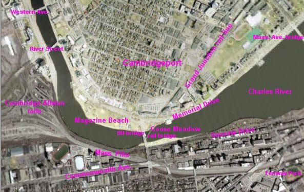
The spaghetti on the left is the area Harvard is targeting for its relocated Medical School one of these Centuries.  The Mass. Pike runs out of it left to right and west to east through the middle and then along the bottom.  Below the Mass. Pike on the left is Boston University.  Above the Mass. Pike is the Charles River and then Cambridge.  The BU Bridge goes straight through the middle, with the Grand Junction railroad bridge under it.

Harvard owns pretty much all of the land covered by the MassDOT study.  Harvard's ownership is subordinate to use for transportation purposes.

Harvard bought its holdings several months after the local transportation agency, the MBTA released a report saying that the railroad bridge under the BU Bridge could be converted to an off ramp from the Mass. Pike to Cambridge.

After issuing the report, the MBTA “realized” that the costs of the project would be too much to pay, given the supposed purpose they were researching, Express Bus service from the Newton Suburb to Cambridgeport / Kendall Square.  The MBTA came to this “realization” with a straight face, inasmuch as the MBTA was talking about, probably, two or three express buses in in the morning and two or three back in the evening.  It does not take an abacus to calculate that such construction would not be justified by two or three round trips of one express bus Monday through Friday.

A lot of the environmental outrages being inflicted on the Cambridge side can be explained as readying Cambridge to received traffic from the Mass. Pike via such a bridge.


2. Destruction of the Wild Area, Stalking Horse for Mass. Pike Off Ramp to Cambridge.

The first presenter last night gave a pitch for the usual stalking horse / bike highway on the Grand Junction railroad bridge.

He described his proposal as providing access from the main BU Campus to BU’s Cambridge Boathouse east of the Wild Area, which in turn is east of the Grand Junction Railroad Bridge.

English translation: he wants to destroy the Wild Area between the Grand Junction railroad bridge and the BU Cambridge Boathouse.

The Wild Area is the next area east of the Destroyed Nesting Area of the Charles River White Geese, on the east side of the Grand Junction railroad.  The Charles River White Geese have been forced to use the Wild Area for nesting because of all the destruction of ground vegetation.  In the worst weather, the Charles River White Geese can be seen in the waters off the wild area seeking protection not available in the Destroyed Nesting Area.

Here is a view of the access to the railroad bridge on the Boston side.  The southern edge of the bridge is the metal pieces showing at the bottom.  If you look closely straight ahead, you will see a green sign above the Mass. Pike.

This highway proposal would cross the bridge running from the Mass. Pike and turn and run (left, behind the camera) through the Wild Area to the BU Cambridge Boathouse.


One of the first happenings after the falsely named Charles River “Conservancy” starting destroying the environment for the Department of Conservation and Recreation was the destruction of all ground vegetation in the Wild Area.

One of the second happenings after the Charles River "Conservancy" started the environmental destruction for the DCR was the destruction of most of the ground vegetation in the Destroyed Nesting Area west of the Grand Junction railroad bridge.

Omitted from destruction in the Destroyed Nesting Area was that area in and near the area which the DCR wanted to destroy as part of the rebuilding of the BU Bridge.

At least one depiction of the off ramp from Mass. Pike to Cambridge showed an access ramp going through the Wild Area.  It is no coincidence that the supposed bike highway would connect to the BU Boathouse through exactly that path.  Such a route would create most of the off ramp desired for the ramp from the Mass. Pike.

Here are the DCR plans for destruction of the Wild Area as part of the DCR’s proposed destruction of hundreds of trees between the BU and the Longfellow Bridge, the second bridge east of the BU Bridge.


The impact of the DCR plans is the same in the two versions of the plans not kept secret, plans dated 2003 and 2009.  The current game is maximum secrecy, maximum damage. $20 million was bless by the legislature in 2014.

The DCR plans show exactly one tree not being destroyed.  They do not deign to mention anything else.  Dishonesty is the norm dealing with these people.

Here is the BU satellite photo showing the Wild Area published in 2014.


Here are photos by me of the Wild Area from the BU Bridge taken last winter and a week or so ago.


The small white figures in the immediately above photo are members of the gaggle of the Charles River White Geese.

Here is a photo from the worst of last winter of the Charles River White Geese swimming in the apparently only part of the Charles River not frozen over at that time.  The photo is taken through the Wild Area.


All trees between the Grand Junction railroad and the yellow BU Boathouse would be destroyed but one.


3. The Architects’ Proposal.

MassDOT’s most recently announced plan would rebuild the Mass. Pike in the narrow part of the photo area of the first photo, between the BU Bridge and Harvard’s property to the left.

MassDOT’s proposal is responsible.  Most of the road in this area is on stilts, starting at about the Grand Junction and going west.  They would tear it down and rebuild it pretty much in place.  Part of the adjoining Soldiers’ Field Road would be moved under the Mass. Pike to allow minor widening, with all of the widening toward Soldiers’ Field Road and the Charles River.

The Architect proposal would rebuild it on the ground with extensive parts of their related items built at least in part on a new retaining wall which would destroy the animal habitat on the edge of the river and any inconvenient trees.  They would probably cantilever above the river.

The Architect giving the presentation, among other examples, show irresponsibly built parts of the river roads abutting the Charles River as good examples of what he was proposing.

His argument basically was that they had done this sort of thing before, why not again?

A lot of responsible people condemn the same construction as irresponsible behavior which should not be repeated, much like dumping waste in Boston Harbor.  At the same time as this construction was being done on the Charles, waste was being dumped in Boston Harbor.  The “responsible” architect did not extend his comparison to the obvious irresponsibilities of his comparisons.


4. Related matters.

I submitted written comments which were an expansion of my most recent report, posted at http://charlesriverwhitegeeseblog.blogspot.com/2015/09/charles-river-massdot-plan-for-mass.html.

There were significant changes, but the entire thing really is too big for one report.  I will follow up with portions.

Clearly these presentations were irresponsible.

The pitch they are giving, in addition to supposed glorious ideas, was allegations of cost savings.

This could be dangerous.

We have a commendable agency, MassDOT, whose responsibilities were expanded by the legislature by giving MassDOT major responsibilities of the now deceased Metropolitan District Commission.  The rest of the MDC was folded into the DCR.

The legislature achieved part of its goals in putting a responsible agency, MassDOT, on the Charles River bridges.  MassDOT has been commendable in standing up to outrages from DCR / Cambridge government types on the Charles River and has been commendable in standing up to similar outrages on the Grand Junction.

The folding of the MDC into the DCR was a waste of time.  The MDC lives without meaningful change except in name.  It is silly to make a distinction between MDC before and DCR after.  They are both vile and very compatible with the destructive City of Cambridge, MA.

And we have a ramping up of DCR / Cambridge type fight for destruction on the Charles River.

Friday, September 11, 2015

Charles River, MassDOT Plan for Mass. Pike, Irresponsible environmental manager, irresponsible alternate proposals.

Charles River, MassDOT Plan for Mass. Pike, Irresponsible environmental manager, irresponsible alternate proposals.

0. Introductory.
1. Summary.
2. One very telling piece of the DCR’s Record — the Creation of an annual blight by the DCR's  use of poisons on the Charles River..
3. The DCR adds Contempt for Resident Animals to its Contempt for the Land and Water of the Charles River.
4. The DCR uses blatant lies in its fight for destruction on the Charles River.
A. General.
B. Lies in the attacks on the Charles River White Geese.
C. Lies in the construction of the bizarre wall walling off the Magazine Beach playing fields from the Charles River.
D. Lies in the reduction of playing fields at Magazine Beach.
E. Lies in the DCR's fight to destroy hundreds of trees between the BU and Longfellow Bridges.
F. Fight for destruction by the falsely named Charles River “Conservancy.”
G. The latest project of the fighters for destruction — the Grand Junction outrage.
H. Some Destruction by the falsely named Charles River “Conservancy:”
I. The most visible victims of these multiple outrages — the Charles River White Geese.
J. More destruction in the Destroyed Nesting Area of the Charles River White Geese — Railroad Worker destruction blessed by the DCR in spite of Cambridge Conservation Commission objections.
K. Cambridge’s planned destruction in the Destroyed Nesting Area and the Wild Area.
L. The DCR is unfit for environmental management in general and, in particular, management of the open space being created.
M. Have the legislature prohibit this irresponsible entity from responsibility for the new open space and Soldiers Field Road.
5. The DCR’s Cheerleaders and related, fighting for more destruction, should be rejected along with the DCR whom they idolize.
6. Use the terrible DCR Record as the basis for prohibitions in use of created open space.
7. Green Line A spur from Comm. Ave. and the BU Bridge in Boston to Harvard Station in Cambridge.
8. The context.


0. Introductory.

This report, of necessity, only reflects a tiny part of the problem with the Department of Conservation and Recreation and its friends, whether declared friends or supposedly independent.

The original draft was written on my smart phone on the set of a major movie on which I was working, during down time in “holding.”  The original drafts has been expanded and clarified, but the core is unchanged.

I am amazed at how much good work I got done under those circumstances, and amazed at the subsequent amount of work which was necessary to expand, refine and clarify while realizing that very major parts of this terrible record must, of necessity, be omitted.

Here are the most recent plans of the Massachusetts Department of Transportation for the largest part of the work they are doing on the Mass. Pike at the future home of the Harvard Medical School.  The Charles River is on the right.  The proposed new green space is the area marked green abutting the Charles River.


The lower right corner of the above map shows on the left of my following marked up edit of an MBTA provided apparent satellite photo.  That area is still present.  It is under the proposed rearrangement of the Mass. Pike in the above plan.

The Magazine Beach playing fields are above the Charles River.  In the middle of the photo is the BU Bridge.  Running under the BU Bridge from left to right is the Grand Junction railroad bridge.


1. Summary.

The biggest defect in the current plan of the Massachusetts Department of Transportation for the rearrangement of the Massachusetts Turnpike (I90) on the Boston side of the Charles River is the reprehensible record of the entity which has charge of the environmental improvements which would be created.

The biggest problem with too many those who want the most important changes to the MassDOT plan is that too many of the change seekers are hand in glove with the environmentally destructive entity which is the likely manager of the environmental improvements and are fighting for the destructive cause of that vile organization.

It must be recognized that this report, of necessity, is a very abbreviated report of the vile record of the DCR and its fellow destroyer, the City of Cambridge.


2. One very telling piece of the DCR’s Record — the Creation of an annual blight by the DCR's use of poisons on the Charles River..

One, and by no means not the only, excellent example of the problem with the Department of Conservation and Recreation is the annual algae infestation on the Charles River.

This infestation originates in the DCR’s love of dumping poisons on the banks of the Charles River.  Several years ago, their beloved poisons were not performing up to snuff at Ebersol Field near Massachusetts General Hospital.   MGH, in turn, is located not far from the dam which turns the eastern end of the Charles River into a managed pond.

So the DCR dumped on Ebersol Field poisons marked “Do not use near water.”

The next day, the Charles River was dead with algae from the harbor to the Mass. Ave. Bridge.

Since then, this outrage is an annual infestation.


3. The DCR adds Contempt for Resident Animals to its Contempt for the Land and Water of the Charles River.

The DCR adds to its contempt for its land and its waters contempt for the animals who live there whom it has a duty to protect.

The DCR’s “master plan” for the Charles River calls for the killing or driving away of all animals residing there.

The bizarre wall the DCR has built walling off the Magazine Beach playing fields from the Charles River has no apparent purpose except to starve the 34 year resident and valuable tourist attraction, the Charles River White Geese.

This bizarre 14 foot high wall of introduced vegetation exists nowhere else on the Charles River Basin.  It has only one tiny opening, the former location of a boat ramp which was destroyed by the DCR without explanation.

Here are some photos of this introduced wall.

The first photo is from the Boston side of the Charles River.


The tiny figure is that of an adult woman.  She is standing in the only opening of this outrage.


This is a before picture.


The bizarre work at the playing fields included the addition of a series of massive, never trimmed, bushes to block off the only opening to the Charles River White Geese.  This outrage makes entry by the Charles River White Geese impossible.


4. The DCR uses blatant lies in its fight for destruction on the Charles River.


A. General.

Added to the contempt for water, land and animals, is the flat out lying by which the outrages are achieved.


B. Lies in the attacks on the Charles River White Geese.

In the Boston Sunday Globe’s section leading report of the DCR’s commencement of this heartless abuse of the Charles River White Geese, the Globe combined a telling photo with their quote of a flat out lie which has been repeated by the DCR for most of the last 15 years.

The photo was that of a small goose standing next to and overwhelmed by earthmoving equipment being used to take away its food and its home at Magazine Beach by keeping it from the playing fields.

The flat out lie was printed right next to that photo.  The key manager never stopped lying of his lack of intention to harm the beautiful animals he and the DCR have been heartlessly abusing.  Except in small meeting when he claimed the right to this heartless abuse was justified by the irresponsible provisions in the “Charles River Master Plan.”

That Charles River Master Plan calls for the killing and / or driving away of all resident animals on the Charles River Basin.

Here is a photo of friends of the Charles River White Geese feeding the hungry animals when they were first deprived of their food and home of most of the last 34 years.


And cheerleaders praise the heartless abuse of this valuable gaggle which has survived on its own for 34 years in the middle of civilization, loved by decent human beings and an active tourist attraction until the heartless abuse.


C. Lies in the construction of the bizarre wall walling off the Magazine Beach playing fields from the Charles River.

The bizarre wall was implemented as a blatant falsehood in violation of yet another provision of that “Charles River Master Plan.”  That was the direct promise to build a lawn to the river.  When the DCR, by the introduction of the bizarre wall, proved that the DCR was lying, the DCR simply changed the lie after the fact.

The DCR’s official explanation of the starvation wall may be that proclaimed by the falsely named Charles River “Conservancy.”  The CRC conducted a swim in to brag of the IMPROVEMENTS TO SWIMMING supposedly provided by the poisons and by the bizarre wall constructed by the DCR and Cambridge.


D. Lies in the reduction of playing fields at Magazine Beach.

The DCR also promised improvements to the playing fields.  This was proven a lie by the destruction of playing field space to put in an expensive drainage system to drain off the DCR’s beloved poisons. ..

The DCR and Cambridge destroyed native grass on the playing fields which had survived without poisons for the better part of a Century.  The DCR and Cambridge then destroyed the playing fields to drain off the poisons being dumped on the shores of the Charles to keep alive sickly grass which has no business on the banks of the Charles.

The DCR’s beloved poisons and sickly grass have been ineffectual.  The sickly poison drinking grass which replaced responsible grass is scheduled to be destroyed again.  It is scheduled to be rebuilt and replaced with more poison drinking sickly stuff.  Additionally, the DCR wants to destroy the responsible native grass on the hillside to the west of the playing fields and the responsible native grass in the wetlands behind the swimming pool.

You guessed it.  They are putting in more sickly grass which needs poisons, poisons not needed by the responsible NATIVE grass they want to add to their destructive record, and which has survived responsibly for the better part of a Century.


E. Lies in the DCR’s fight to destroy hundreds of trees between the BU and Longfellow Bridges.

You add to this the fight to destroy hundreds of excellent trees between the BU and Longfellow Bridges.  The “explanation” for this outrage varies with the audience.

The earliest “explanation” for the destruction translated as “won’t it look great in 40 years.”

In 2009, the Boston Globe did a story on the DCR seeking Obama recession fighting moneys to destroy the hundreds of trees currently threatened.  The lie then was that the DCR was DESTROYING ONLY SICKLY TREES.  I have the plans and am happy to provide them.  As may be readily observed, none of the targeted trees are diseased, and none of the destruction plans call any of them diseased.

But the Boston Globe thought they were dealing with a responsible agency and the Boston Globe happily printed this blatant lie.

In 2014, the State House blessed the destruction with an allocation of $20 million.

Here are some of the targeted, excellent trees.  It really is impossible to fully communicate the scope of this outrage.

The first tree looms over the Destroyed Nesting Area of the Charles River White Geese.  It is located very close to the BU Bridge.


Destruction plans are posted at http://charlesriverwhitegeeseblog.blogspot.com/2014/04/tree-destruction-plans-charles-river.html


F. Fight for destruction by the falsely named Charles River “Conservancy.”

The falsely named Charles River “Conservancy” bragged when money was first put on the table in the 2014 legislative cycle that the money was the implementation of a petition the CRC had distributed WHICH MADE NO MENTION OF MASSIVE TREE DESTRUCTION.  Naturally, this falsely named group used the latest excuse for massive destruction.

The project which this destructive entity obtained signatures in support of for was an irresponsible project to create “underpasses” under the next three bridges.  MassDOT, being a responsible agency has condemned this project as environmentally irresponsible and a waste of state money.


G. The latest project of the fighters for destruction — the Grand Junction outrage.

Now a lot of people who fought for all of this irresponsible destruction, and who want the irresponsible DCR to manage the MassDOT proposed increase in open space in Boston, are spouting pious about spending money on yet another destructive project.  Their latest supported outrage involves more destruction on the Cambridge side of the Charles River as a result of the misuse of the Grand Junction railroad bridge.

The DCR’s tree destruction plans call for all trees EXCEPT ONE to be destroyed in the Wild Area between the railroad and the BU Boathouse.

Here is the relevant part of their destruction plans.  The broken lines running from bottom to top in the middle of the plan is the Grand Junction railroad.  To the right of the plan is BU's Cambridge Boat House.  The DCR shows one tree NOT destroyed.  They do not even dignify the massive destruction by pointing out destroyed trees.


Here is what the targeted dense woods, the Wild Area look like now.  The above plan would destroy EVERY tree BUT ONE between the Grant Junction railroad bridge and the (yellow) BU Cambridge Boathouse.

This picture was taken in the worst of the last very bitter winter.


This photo was taken September 12, 2015, during the preparation of this blog report.  The small white figures are part of the Charles River White Geese.


Here are the Charles River White Geese in the water beneath the Wild Area during that terrible winter.  This was the only free water available..


Here is an older picture of the desperate Charles River White Geese hunting for some food in the railroad right of way.


H. Some Destruction by the falsely named Charles River “Conservancy:”

The falsely named Charles River “Conservancy” has, by agreement with the DCR, acted as environmental destroyer for the DCR.  After the agreement, all ground and hillside vegetation was destroyed in the Wild Area between the Grand Junction and the BU Boathouse.  This is the same heavily treed area where the DCR plans call for destruction of all trees but one.

About half the ground vegetation in the area between the railroad and the BU Bridge was destroyed.  The DCR’s overly destructive BU Bridge repair plans destroyed most of the undestroyed ground vegetation.  “Remediation” of the DCR’s destructiveness in the BU Bridge repair plans has been nonsensical.  To the extent introduced vegetation lives, it is vegetation comparable to the irresponsible stuff walling off the Charles River from the playing fields.


I. The most visible victims of these multiple outrages — the Charles River White Geese.

Who does this heartlessly abuse?  The Charles River White Geese, of course.


This area is the portion of their habitat they used as their Nesting Area and for protection during bad weather.  It was lush and beautiful, supporting a variety of wild animals, all condemned by the vile provisions in the Charles River Master Plan to kill off or drive away all resident animals.


The 34 year resident Charles River White Geese are confined to this destroyed area without food.

The DCR have made it worse.


J. More destruction in the Destroyed Nesting Area of the Charles River White Geese — Railroad Worker destruction blessed by the DCR in spite of Cambridge Conservation Commission objections.

The Cambridge Conservation Commission condemned irresponsible use of the not destroyed portion for parking on a project on the tracks by railroad workers.  They were too lazy to park next to Memorial Drive in a manner comparable to the responsible parking accomplished by MassDOT in its implementation of the DCR’s irresponsible BU Bridge repair plans.


So the DCR told the workers to get out of the tiny portion of the area in the CCC’s jurisdiction.  The DCR BLESSED THE IRRESPONSIBLE AND DESTRUCTIVE PARKING elsewhere, which added to the destruction of the ground vegetation and which destroyed larger vegetation.

The DCR’s bedfellows dumped crushed stone in this previously lush area.  When they left an additional load of truck stone was dumped in the area after parking use had ceased.


MassDOT implemented the DCR's plans for BU Bridge repair as responsibly as possible, with none of this outrageous parking.  Here are two photo of the highway ramp where responsible management would have parked.

Under the Memorial Drive overpass was being used for another project (the fence).  There was still plenty of room to park to the left of the on ramp, if the people in charge are / were fit for their jobs.  The corner to the right in the first photo is the entrance to the Destroyed Nesting Area.


The next photo shows the staircase illegally constructed by Boston University at about the location of the car further away in the above photo.


These photos show the horrible walk these husky workmen would be faced with if they were too lazy to climb the stairs.  This and a related walk are the only places crushed stone should be placed.  Both are in the BU Bridge repair area and supposedly are remediation.


K. Cambridge’s planned destruction in the Destroyed Nesting Area and the Wild Area.

Cambridge has its own destructive plans which include building in the Destroyed Nesting Area and building a fence preventing direct access between the Destroyed Nesting Area.  The Charles River White Geese have been forced to nest in the dirt of the Wild Area because it is less destroyed than the Destroyed Nesting Area.

Cambridge pols are publicly campaigning for the destruction with the usual lies of omission.  They praise the overall proposal and “neglect” to mention the destruction and heartless animal abuse on the banks of the Charles River.

Here is a copy of the plan the Cambridge pols keep as secret as possible.


Not only should the environmental outrages on the Cambridge side not be expanded as part of the Mass. Pike work, this irresponsible, rogue department should have no responsibilities for any area created as part of the Mass. Pike work.


L. The DCR is unfit for environmental management in general and, in particular, management of the open space being created.

Ideally, the DCR should be barred from management of the open space being created and barred from Soldiers Field road.


M. Have the legislature prohibit this irresponsible entity from responsibility for the new open space and Soldiers Field Road.

The legislature, in its wisdom, has shown its contempt for the DCR / its predecessor by transferring the river bridges to MassDOT.

The truly irresponsible DCR should be barred from any expansion of its irresponsible behavior, and from management of Soldiers Field Road..


5. The DCR’s Cheerleaders and related, fighting for more destruction, should be rejected along with the DCR whom they idolize.


And its cheerleaders, including those complicit in this terrible record of the DCR, should simply be treated with the lack of respect due the destructive agency they support without condition.

Harvard bought the prime area of this study a few month's after the MBTA showed how this railroad and railroad bridge could be converted to an off ramp from the Mass. Pike to Cambridge.  So many outrages fit a pattern of upgrading Cambridge to handle this traffic.  So we get lovely sounding con games.


6. Use the terrible DCR Record as the basis for prohibitions in use of created open space.

The terrible DCR record should stand, at minimum, as the basis for a point by point prohibition of action in Boston which follows on the outrages in Cambridge.  Description of prohibited acts should point by point condemn further outrages and lying by the DCR in Boston.

Naturally, this is only a far inferior alternative to barring the DCR from the created lands and Soldiers Field Road because of its proven irresponsibility.


7.  Green Line A spur from Comm. Ave. and the BU Bridge in Boston to Harvard Station in Cambridge.

This is an ideal time to go forward with this project, which is badly needed by the residents and employers of North Allston.

I have provided an extensive series on this matter.  The most recent report is at http://charlesriverwhitegeeseblog.blogspot.com/2015/07/charles-river-olympics-rapid-transit_23.html

8. The context.

Here are 33 photos of destruction in Cambridge of which the Charles River outrage is just a part.

http://charlesriverwhitegeeseblog.blogspot.com/2015/05/charles-river-more-money-for.html.