Two new “initiatives” on the Charles River. BOTH SCARY. Plus Cambridge’s preventing meaningful “public review” of the real stuff.
1. Introduction to the “initiatives.”
A. Close Memorial Drive on “Saturday.”
(1) Not to look at ongoing destruction FUNDED AND SUPPORTED BY THE CITY COUNCIL including destroying the excellent MicroCenter Grove on Magazine Beach across from the MicroCenter store.
(2) Not to look at YET AGAIN attempts to destroy the magnificent Wild Area east of the BU Bridge which powers that be in Cambridge have been to destroy since at least 1986.
B. The Grand Junction “Path.”
(1) General.
(2) M.I.T.’s Private Ramp from I-90 and possibly further.
(a) Current status.
(b) Prior game defeated.
(c) The game.
(3) Boston, once again, reflects sanity.
2. Restrict “public” review of plans to A GOVERNMENT CONTRACTOR, the Charles River Poisoner and her friends.
3. A responsible alternative WHICH WOULD BENEFIT CAMBRIDGE AND BOSTON WITHOUT the beloved massive destruction.
1. Introduction to the “initiatives.”
There are two “initiatives.”
A. Close the Memorial Drive on “Saturday.”
Memorial Drive is the state owned boulevard which follows the Charles River on its north side . A LOT OF HARM HAS ALREADY BEEN DONE TO IT BY CAMBRIDGE AND BY MASSACHUSETTS’ DEPARTMENT OF CONSERVATION AND RECREATION. The pitch being passed on to well meaning people tells them not to look at the outrages already accomplished or planned, destruction of hundreds of mostly excellent trees. Close Memorial Drive on Saturday. Ignore the terrible record of government. See our detailed video for the real record at https://youtu.be.com/dWyCdcWMuAA.
The concept of closing Memorial Drive on Saturday IN ADDITION TO CLOSING IT ON SUNDAY was originated in City Council IMMEDIATELY after the City Council got a bunch of letters from people west of Harvard Square afraid that the Department of Conservation and Recreation was going to destroy more trees on Memorial Drive, this time in their portion.
Apparent friends of the City Council announced the creation of yet another possibly fake protective group, to close Memorial Drive on Saturday in addition to closing it on Sunday.
Closing on Saturday very much will not happen because of the very great harm likely to too many people, BUT FIGHTING TO CLOSE IT WILL KEEP CONCERNED PEOPLE “OUT OF TROUBLE.”
Crucial in the creation of this group is the repeated pattern of so many “protective” groups appearing in Cambridge when destructive action is likely, action which is favored by the “powers that be.”
Such entities give the impression that“the right kind of people” are getting active. The “right kind of people” in such groups commonly are dominated by development / contracting professionals and people with major connections to local institutions. Folks dominating things neglect to mention dirty hands.
I have a lot of experience MEANINGFULLY GETTING THINGS DONE IN CAMBRIDGE. My victories commonly have had such groups on the losing side. Here is a map showing the most controversial part of my zoning victories, along with a table detailing those victories, WITH TOO MUCH HARM DONE TO THESE VICTORIES BY RECENT CITY COUNCIL ACTIONS.
“Activism” and suddenly appeared “protective groups” are a standard con when outrages are coming. Get people to chase their tails, i.e. chase a nominally lovely idea which CANNOT GET DONE. Get people to ignore the real problem which is connected to the city government / its friends.
In this instance the game is to distract people from destruction on the Charles River in the BU Bridge area. Two key examples:
(1) Not to look at ongoing destruction FUNDED AND SUPPORTED BY THE CITY COUNCIL including destroying the excellent MicroCenter Grove on Magazine Beach across from the MicroCenter store.
The Cambridge City Council has funded an “activist” on this project who, acting as contractor for the DCR poisoned the Charles River. She has given the City Council plans SHE HAS AGREED TO which would destroy that grove.
Here is the doomed grove:
Here is the relevant part of the plans she gave to the Cambridge City Council showing that she has already approved creating the parking lot she supports replacing those trees with.
The number “3" in the middle of the current location of those trees. The parking lot is on top of them.
Her most significant record is her poisoning of the Charles River as contractor for the DCR.
The key event was when Cambridge and the DCR started their heartless starvation of the 43 year resident Charles River White Geese. This was pretty much the same time that the DCR and Cambridge started poisoning the previously pristine playing fields at Magazine Beach where the Charles River White Geese lived and fed. Cambridge and the DCR spent a bunch of money creating artificial drainage for poisons they should not even be dumping on the banks of the Charles River.
Here is how the Charles River Poisoner blocked that drainage. The black area is plastic replacing healthy vegetation that constituted the drainage. The healthy vegetation was pulled up and then carted away by the Cambridge Department of Public Works. This was followed by blocking the drainage with the black plastic. The blue area near the top is the Charles River.
Here is just one of a number of photos from Phil Barber that I have published of the resulting algae infestation when the poisons that had been drained away was rerouted into the Charles:
The filth the Charles River Poisoner created in turn created a public health emergency in the Charles River east of the Mass. Ave. Bridge which is the next bridge east of the BU Bridge.
So naturally, the Cambridge City Council paid her for planning environmental work. She was “planning” work she and the DCR, as shown above, had already decided to do, and provided those plans to the Cambridge City Council.
Here are the DCR plans on Magazine Beach filed with the Cambridge Conservation Commission, as we passed them, along with photos, to the Cambridge City Council: http://www.friendsofthewhitegeese.org/agenda1.pdf.
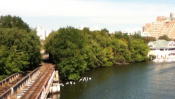
(2) Not to look at YET AGAIN attempts to destroy the magnificent Wild Area east of the BU Bridge which powers that be in Cambridge have been to destroy since at least 1986.
Here is a photo of this excellent woods taken from the BU Bridge, with the Grand Junction Railroad / Bridge to the left and the ghetto to which the Charles River White Geese have been confined AND THEIR FOOD DESTROYED to the far left.
The white figures are members of the gaggle of the beloved 43 year resident Charles River White Geese hunting for food which has been increasingly destroyed by Cambridge and the DCR.
Cambridge and the DCR destroyed hundreds of trees on the Charles River between the BU Bridge and the Longfellow Bridge in 2016. Here is my video / slide show memorializing that outrage: https://www.youtube.com/watch?v=pTplCCEJP7o.
The plans included destruction of the Wild Area. Here is the relevant plan, showing exactly ONE OF THESE TREES NOT DESTROYED.
The Wild Area is to the right. Note exactly one numbered circle / trees NOT DESTROYED in this thick woods.
The DCR did not do that destruction in 2016, but the stench is present now. They are renewing their plans. And originally announced those plans in a “public meeting” scheduled in a highly deceptive manner.
Here are the plans on Magazine Beach filed with the Cambridge Conservation Commission, as I passed them, along with photos, to the Cambridge City Council: http://www.friendsofthewhitegeese.org/agenda1.pdf.
Games have been played WITH A CITY COUNCIL WHICH HAS DONE REALLY DESTRUCTIVE STUFF IN RECENT YEARS, WHILE YELLING AT THE OTHER GUY.
As part of the game, the DCR has apparently “agreed” to move “improvements” to Memorial Drive east of the River Street Bridge (first bridge WEST of the BU Bridge) to SECRET handling, with review only by A GOVERNMENT CONTRACTOR, the Charles River Poisoner and friends, AS FRAUDULENT “PUBLIC INPUT.” In place of supposedly meaningful review which would be done west of Harvard Square.
B. The Grand Junction “Path.”
(1) General.
This supposed “improvement” would pretty up the Grand Junction Railroad starting several hundred feet north of Memorial Drive. The discussion I observed included a RESPONSIBLE woman asking what goes on below the several hundred feet point. The response of the bureaucrats was MISLEADING, to put it mildly.
As usual, the apparently visible part is innocuous, but there are very major problems.
(2) M.I.T.’s Private Ramp from I-90 and possibly further.
(a) Current status.
The best presentations on this proposal were done in a package from the Massachusetts Institute of Technology to the Cambridge City Council in 2014.
The portion marked “MIT” has since been sold to Harvard. Plans presented by the Massachusetts Bay Transportation Company in 2003 would run a highway through pretty much the entire colored area, with access ramps to and from I-90 which can be seen in the lower left corner. The new highway would cross the Charles River on a widened Grand Junction Bridge going under the BU Bridge, and would directly connect to I90 west bound (traveling to the upper left), By a ramp crossing I90 in the lower left corner. The MBTA proposal would connect I90 east bound traffic to Cambridge. THAT IS THE GAME.
The Destroyed Nesting Area, the ghetto to which the 43 year resident and beloved Charles River White Geese have been confined WITH ALL FOOD DESTROYED is between the Grand Junction and the BU Bridge. The Wild Area is the area to the right of the Grand Junction following the Charles River.
From the same source, with one modification by us, M.I.T. showed the various options in play.
The area marked 5 is the connection to the Mass. Pike over the widened Grand Junction Bridge. The route marked 2 is the current supposed proposal. Under the current supposed proposal, the new bike path would connect from the Grand Junction to THE TRAFFIC NIGHTMARE at this block of Brookline Street, Cambridge.
The area marked 4 is probably the one honest presentation of attacks on the Charles River White Geese. This bike highway supposedly does not exist now YET. The powers that be will suddenly “discover” THE TRAFFIC NIGHTMARE. The new highway would be extended to destroy the already Destroyed Nesting Area of the Charles River White Geese and, preferably, from their point of view, to widen the Grand Junction Railroad Bridge in accordance with the MBTA report..
Following the Grand Junction up to the upper right, is a crossing to Vassar Street, parallel to the Grand Junction Railroad. M.I.T. was proposing to connect the bike path to the Charles River by this route, marked 1. Recently, the City Council voted for a change in property rights to allow what looks like a blockage of this route by another M.I.T. dormitory. Following Vassar Street to the left, the street turns. At this point, we have marked in the sane route for the bike path to access the Charles River. This would require moving private parking in this location to a created parking terrace on the river side of Vassar Street which is currently used for unstructured parking.
The sales pitch from the bureaucrats in the Grand Junction Path meeting I attended to a responsible question told the questioner not to worry about what would be done between the currently proposed bike path and the river. THE QUESTION OF THE RESPONSIBLE WOMAN WAS SHOUTED DOWN.
This is the area reflected in the plans above as being destroyed except for one tree in plans being maneuvered through maximum secrecy.
This is the Wild Area, which Cambridge bureaucrats have been trying to destroy since at least 1985. A proposal initiated by me has killed a subway line proposal which would have crossed the Charles at this point. That coming subway would now appear to be ending at Kenmore as a spur off the Orange Line running from Ruggles, in a partial implementation of my proposal.
This is the real destructive part, featuring and fully predictable, the Wild Area that the Cambridge bureaucrats have been trying to destroy since 1986. A refuge of free animals, most visibly the loved Charles River White Geese.
Cambridge bureaucrats and the ALWAYS ACTIVE developer / contractor lobby hate free animals. They have “no value.” English translation; NO MONEY TO THE CONTRACTORS / DEVELOPERS.
So destroy, destroy, destroy.
(b) Prior game defeated.
The first attempt I was aware of was to run a subway through the Wild Area. The contractor / developer / institution lobby shot themselves in the foot. An initiative initially proposed by me has moved the subway proposal about a mile to the east, now probably terminating at Kenmore Square next to the Red Sox’ Fenway Park.
Key to that defeat of Cambridge’s Developer / Contractor lobby was a project across the street from Fenway Park based on the Commuter Rail station there, now called “Landsdowne Station.” The bureaucrat’s beloved destruction of the Wild Area would have required moving Landsdowne Station a block from the heart of the Boston University campus.
Landsdowne Station has seen a gilding with public moneys and two new massive privately funded buildings as part of a now approved four building project. The gilding of Landsdowne Station with state moneys came not that long after I informed the developer of Cambridge’s wish to move Landsdowne Station. A key part of his project is the excellent transportation coming as part of the Superstation on the alternate subway route I proposed.
This project is associated with the alternative I proposed for the subway Cambridge has been fighting for which would destroy the Wild Area. The subway alternative, instead of crossing the Charles River through the Wild Area, would go under playing fields of M.I.T., cross the Charles west of the Mass. Ave. Bridge (the next bridge east of the B.U. Bridge), create a superstation at Kenmore connecting to all Green Line branches there and to commuter rail, and then proceeding under Brookline Avenue (or so) with a possible station in the Brookline Avenue / Fenway area, a VERY IMPORTANT STATION at Louis Pasteur and Longwood supporting the Harvard / Longwood Medical Area, and then link at Ruggles Station to the Orange Line subway. The northern end would connect to the Orange Line in Charlestown.
Cambridge / M.I.T. have played games to make the route north of the Charles much more expensive. The obvious result is to simply build this subway line as an Orange Line spur running from Ruggles to the Superstation at Kenmore Square / Station. The important part of the subway line is necessary transportation for the Massachusetts cash cow at the Harvard / Longwood Medical Area. That can be very effectively accomplished with the subway terminating at Kenmore Square / Station.
Landsdowne Station with its gilding and the now approved four building project would be part of the superstation. Landsdowne Station is not going to be moved.
On general principles, here is the gilded Landsdowne Station as part of the larger of the two existing buildings. To the right of the station is I90. The bridge in the rear of the photo is Beacon Street connecting Kenmore Square / Station to Brookline. Behind the camera is the Brookline Avenue bridge connecting Kenmore Square / Station to Fenway Park. That bridge will be a major part of the final two buildings in the Landsdowne project, including connection to Kenmore Square / Station as part of the coming Superstation.
Another loss for Cambridge’s destructive Developer / Contractor / Institution lobby.
(c) The game.
The Grand Junction “Path” game is a private exit from I90 (Massachusetts Turnpike) to M.I.T. and beyond, assisted by the lovely park being created WHICH CAN READILY BE DESTROYED FOR THE HIGHWAY KILLED FIFTY YEARS AGO. The highway would go as far as the lobby can make it.
The Developer / Contractor / Institution lobby has fought to get state moneys to set up the beginning of that outrage, the upgrading of the Grand Junction railroad bridge as part of apparently needed improvements to I-90. The private exit ramp / whatever will only work if that bridge is widened.
(3) Boston, once again, reflects sanity.
What is happening off that is up in the air. The REAL PURPOSE has been to use state proper planning to counter the effect of fifty years of wear and tear on I-90 (Mass. Pike) across from Magazine Beach. The planning has gotten distressingly secret although I followed it for years. The visible part appears to be outrageous construction in the Charles River, but the always present widening of the Grand Junction railroad bridge could be in there.
Last I was hearing, powers in Boston seem to have blocked funding because the obvious part of the project would create yet another campus for Harvard University, the triangular Allston Village campus, wide at Soldiers Field Road on the Charles (the Boston correlative to Cambridge’s Memorial Drive), pointed at the other end a block from Boston’s Allston Village student area. East and west boundaries would be Boston University West and an existing residential neighborhood plus a much larger existing residential neighborhood separated by Cambridge Street. See my analysis above.
I have had two major victories in this project. The part really being bragged about by the I-90 project management would connect Harvard’s new Allston Village campus to Soldier Field Road heading toward and from Downtown Boston. That was my idea. In fact, in an extremely unusual action for a MassDOT public meeting, I was shouted down by the chair when originally I made the suggestion. He, in interrupting me, called my idea to rearrange the ramps outside the parameters of their authority.
Here is drone footage of the area from “From Cambridge to Boston with the DJ Inspire 1 Drone footage,” https://www.youtube.com/watch?v=sN-OmMzvHhw. This shot is from minute 10.02. The lower end of the photo shows the river / flat end of Harvard’s triangular Allston Village Campus at the point where the new intersection will be constructed. On the near side of the river is the area where the Cambridge City Council is fighting to destroy the MicroCenter Grove. Above the new intersection will be the Allston Village Campus. The point of the triangle at the top is about one block from Allston Village.

At the bottom of this photo can be seen that portion of Magazine Beach in Cambridge WHERE THE CHARLES RIVER POISONER IS BEING PAID BY THE CAMBRIDGE CITY COUNCIL TO “PLAN” DESTRUCTION OF THE MICROCENTER GROVE. Earlier in this report are the plans SHE gave to the City Council years ago showing that she had already agreed to destroy the MicroCenter Grove. The edge shown in this photo is immediately south of the doomed grove and to the left / east of the small building which is visible.
My other victory in the I-90 Project was to restrict the access from Soldiers Field Road to the River Street Bridge (next bridge west of the BU Bridge) so that the ramp only goes to Cambridge rather than the current situation where the ramp is clogged with traffic that would be moved to the new connector. That bridge is the extension of the road to the right end of this photo. The road continues to the right as the River Street Bridge, running over the Charles River.
What is being used by the Boston folk, it would appear, to restrict funding is the fact that the Allston Village Campus would have its street structure LAID OUT FOR HARVARD WITH STATE MONEY. The Boston folk think Harvard should pay to create Harvard’s new campus.
Very helpful. If Boston can kill the widening of the Grand Junction bridge, the building in the Charles, and Harvard’s nonsensical and DUPLICATIVE private commuter rail station keyed into, of course, building up the Grand Junction Railroad area in Cambridge, that would be excellent.
Harvard’s holdings date back to the time when the “Inner Belt” was killed for the time being.
But it is terrific to see Boston, once again, standing up to outrages centered in Cambridge.
2. Restrict “public” review of plans to A GOVERNMENT CONTRACTOR, the Charles River Poisoner and her friends.
The DCR plans have been “modified.” The area west of Harvard Square gets “PUBLIC REVIEW.”
The area east of the River Street Bridge (the first bridge west of the BU Bridge has been transferred to SECRET PLANNING. This is the real stuff, the dirty tricks. The City of Cambridge has that truly fraudulent “protective group” which they DEMAND all :”public” discussions center on.
That fake protective group is really fake. As detailed above, it is a one woman outrage. The woman is the one who, as contractor for the DCR, poisoned the Charles River. She has this very fake protective group which pretty much keeps all plans secret. I have actually seen her / her people lie that no trees will be destroyed in the Magazine Beach reservation in spite of destruction already achieved and planned for the future. Cambridge demands nobody else be given access to plans.
This situation is REALLY OUTRAGEOUS. Fraudulent claims to “public review.” NONSENSICAL CLAIMS OF “PUBLIC REVIEW “.
3. A responsible alternative WHICH WOULD BENEFIT CAMBRIDGE AND BOSTON WITHOUT the beloved massive destruction.
Harvard is pitching a private commuter rail station as a benefit to the neighborhood. The usual nonsense. Commuter rail service is, of necessity, so limited in trips that the neighborhood does not get meaningful benefit.
The impact on public transportation is destructive. Harvard’s private station would be too close the existing new station next to the Everett Street Bridge over the Mass Pike and thus would bizarrely slow down commuters who really need commuter rail. Responsible behavior would be bus service from this “Boston Landing” station to Harvard’s new Allston Village campus.
I have proposed public transportation which would benefit the residential North Allston neighborhood and provide direct connection between Harvard Square and Boston’s Back Bay neighborhood, reducing traffic on the existing Red Line subway between Harvard Square and Downtown Boston, a Green Line A spur running from the intersection of the BU Bridge and Commonwealth avenue to Harvard’s Allston Village Campus above the upgraded I90, and then under North Harvard Street to the residential North Allston neighborhood (where I lived for a semester), and then to Harvard Square.
Such MEANINGFUL transportation improvement would truly be a benefit to the North Allston residential neighborhood, with underground stations at Cambridge Street and Franklin Street.
This proposal, because of the meaningful public transportation, would also be much more attractive to the Biden administration. AND THUS PROVIDE MONEY BOSTON EXPECTS. Additionally, the underground portion would make Boston investment highly appropriate. Plus this connector spur would be of major benefit to Cambridge by improving access to Harvard Square and reducing traffic on the overloaded Red Line beween Harvard Square / Station and Park Street / Station. It thus would make financial contribution by Cambridge highly appropriate.
But the Cambridge lobby of developers / contractors / institutions wants their bennies, including destruction of the BU Bridge area in Cambridge.
So the Cambridge City Council is telling people to chase their tails on Memorial Drive and ignore the outrages supported by the Cambridge City Council.
Here is my map of the responsible alternative. Harvard’s Allston Village Campus is to the left of the lower curve of the river. Harvard Square is at the top middle, with three possible station locations marked. At the bottom right is the BU Bridge. The bottom end of the BU Bridge would be adjacent to the new Green Line A Spur.