I. Introduction.
II. The background.
A. General.
B. Our core area of interest, at the BU Bridge and West of the BU Bridge.
C. The core project area, the future Harvard Medical School and related facilities.
D. The traffic which would turn right onto the River Street Bridge.
E. West Station. The game being played.
III. Marked up Index.
IV. Summary.
I. Introduction.
I have been remiss in my posts on this blog because I have been putting massive amounts of work on Environmental Comments on the Rebuilding of Interstate 90 (Massachusetts Turnpike) and working on other official documents.
The engineers of the Massachusetts Department of Transportation (MassDOT) are submitting a draft Environmental Impact Report (DEIR) to the state environmental people to have the environmental people clean up the report so that the project can satisfy environmental laws.
The DEIR is on line at http://www.massdot.state.ma.us/highway/HighlightedProjects/AllstonI90InterchangeImprovementProject.aspx.
My formal comments on the DEIR to the reviewer go into the dirty work that we are fighting against on the Charles River.
This is the second segment of these formal comments. The first segment was posted at http://charlesriverwhitegeeseblog.blogspot.com/2018/02/highway-rebuilding-i90-on-charles-river.html.
The format of these reports will be that, at the ed of each report, I will provide the index to my overall DEIR comments, and show how far we have gotten to.
II. The background.
A. General.
In Segment 1, I gave the general issues, and one part of the application, to the River Street Bridge area, the next bridge to the west of the BU Bridge.
There is a lot of background information which most people will need to understand what is going on.
This time, I need this background for your benefit.
Of necessity, I mus go into great background detail, but not too great.
The acronym “DEIR” has long been a source of mystery to me. I think, but I am not positive that it means “Draft Environmental Impact Report.”
The “Red Line” refers to the subway line which runs through Cambridge. It is “Heavy Rail,” containing cars which are definitely not up to AmTrak standard, but they are commendable Subway vehicles.
The “Green Line” refers to the subway line in Boston whose B branch generally parallels the Charles River. It consists of highly improved streetcars, very good street cars, but highly improved streetcars.
The “Green Line” at its northern / eastern end is a single subway route. After leaving the core city, it breaks up into four routes, routes B, C, D, and E, counted alphabetically starting closest to the Charles River. The various branches eventually come above ground, moving west from downtown, and travel separated from cars mostly, on islands in the middle of wide streets, with auto traffic, inbound and outbound on either side of the streetcar islands.
Over the years almost all of the streetcar traffic which was not on islands and was mixed with cars has been placed on islands or replaced with bus service.
That is what happened to Green Line A. Green Lines A and B ran up the middle of Commonwealth Avenue generally parallel to and a block or so south of the Charles River. In the area we are concerned about, the BU Bridge runs to Commonwealth Avenue.
The two streetcar lines separated perhaps 10 blocks west of the BU Bridge. Green Line B stayed in the median in the middle of Commonwealth Avenue. Green Line A was the traditional streetcar route on rails in the middle of traffic. It went straight ahead and Commonwealth Avenue, with Green Line B, turned.
Green Line A, with its tracks in the middle of city streets and its stops in the middle of city streets, by strong demand of the voters, was replaced with a bus route. So five streetcar branches to the west in metropolitan Boston became four, and, rather than change a lot of signs, Green Line A simply became non existent.
B. Our core area of interest, at the BU Bridge and West of the BU Bridge.
West of the BU Bridge and between Green Line B / Commonwealth Avenue and the Charles River were Commuter Rail train tracks, real trains designed to bring passengers from the suburbs into Metropolitan Boston. When the creation of Interstates came, Interstate 90 was built along the right of way of the Commuter Rail trains. It was placed north of the tracks, and between the Commuter Rail and Soldiers Field Road. Soldiers field Road is the western boulevard which follows the Charles River on the river’s southern side.
That was 50 years ago.
In our area of interest, at the BU Bridge, Green Line B runs up the middle of Commonwealth Avenue.
The intersection of Commonwealth Avenue and the BU Bridge is built on a bridge itself. The Commuter Rail and I90 run under that bridge, under parts of both Commonwealth Avenue / Green Line B and under the BU Bridge. The Commuter Rail / I90 and Commonwealth Avenue, have vaguely parallel but intersecting routes.
Commuter Rail / I90 passes under bridge structures bearing Commonwealth Avenue and the BU Bridge.
West of the BU Bridge, on the South is Commonwealth Avenue with Green Line B in the middle. Then comes property owned by Boston University. Then comes the Commuter Rail. Then comes I90. Then comes Soldiers Field Road. Then comes the Charles River. At about the point where the Boston University property becomes significant, the Commuter Rail winds up under the raised I90 highway.
On the Cambridge side is our main area of concern: the Magazine Beach reservation which has been the home of the Charles River White Geese for most of the last 37 years, and the Goose Meadow, formerly their nesting area, tow the ghetto which has been made their only habitat.
The I90 / Commuter Rail combination stretches out to the end of Boston University holdings into what was a massive regional rail yard and off ramps from I90 to Cambridge and the Allston and Brighton neighborhood of Boston. In the area between the Commonwealth Avenue / BU Bridge intersection and the rail yard / exit ramps, I90 goes from below ground level to above ground level on raised platforms. The Commuter Rail goes from being parallel to I90 to being under I90.
Two things have happened.
First, I90's multitude of raised / bridge type structures in this area have aged, and the powers that be think that it had better be brought up to the safe standards of our day.
Secondly, Harvard University bought that massive rail yard and the off ramps.
After Harvard purchased the area of freight yards, super highway, and car ramps, the railroad “voluntarily” moved its rail yard to Worcester.
Harvard already has had nearby major holdings in Allston, the most relevant part of which is across Cambridge Street from the rail yard / off ramps. Harvard is building across Cambridge Street.
One block further, beyond Western Avenue, Harvard has the world renown Harvard Business School.
In addition to building across Cambridge Street, Harvard wants to build on top of the rail yard, the Interstate, and the Interstate exits as well. But the remnants of the rail yard and the off ramps are in the way. Harvard’s purchase of the area was made subject by the state legislature to transportation uses.
This former rail yard and soon to be rearranged turnpike exits is the core part of the Allston I90 Interchange Improvement Project. And we are learning exactly what the “transportation uses” amount to.
In our first segment of this report, we provided you with an areal photo of the western end of the project, at the River Street Bridge, the next bridge west of the BU Bridge.
The area between the core area of the highway project and the BU Bridge is shown in the following photograph from the DEIR. The River Street Bridge is far in the distance.

The buildings at the left are Boston University. The BIG highway is I90.
At this point, the Commuter Rail is under I90. The highway to its right is Soldiers Fields Road. Then you have the Charles River and the Magazine Beach Playing Fields in Cambridge which have been the core home of the Charles River White Geese for most of their 37 years in residence. I90 has been here a little bit longer than the Charles River White Geese, 50 years or so, compared to 37 years for the Charles River White Geese.
If you look carefully to the right of I90 at te bottom of the picture, you can see the Grand Junction Railroad coming from Cambridge.
In the upper left of this photo is the main project area, the future Harvard Medical School and related buildings.
The two bridges visible in the distance are the River Street Bridge and the Western Avenue Bridge. We presented a photo in segment 1 looking over the main project area above the River Street Bridge, and repeat it below.
Here is a state satellite photo showing how the BU Bridge and our people fit in. I90 shows in the upper left corner. BU Buildings are in the lover left. Between the BU buildings and the Charles River is Soldiers Field Road.
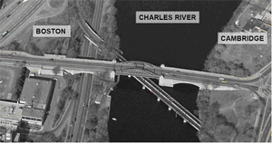
The Destroyed Nesting Area of the Charles River White Geese, at the bottom right, is east of the BU Bridge on the far side of the Charles River. Next to the Destroyed Nesting Area runs the Grand Junction Railroad which crosses the Charles River UNDER the BU Bridge, goes over Soldiers Field Road and then under I90 where it travels between the Commuter Rail and Soldiers Field Road.
The powers that be in Cambridge are fighting, IN SPITE OF STRONGLY COMMUNICATED NEGATIVE VOTER WISHES, to run Commuter rail on the Grand Junction. The powers that be are also fighting to run a super highway off ramp over an expanded Grand Junction Bridge following the Grand Junction from I90 to Massachusetts Institute of Technology. MIT owns a very large portion of Cambridge between the Grand Junction and the Charles River.
In the meantime, they indulge in heartless animal abuse.
C. The core project area, the future Harvard Medical School and related facilities.
Here is the photo I used in the first segment of these reports. This photo is the current situation. At the bottom middle is the River Street Bridge. Meeting it from its left and just above the Charles River is the off ramp which we discussed in Segment 1.
Straight ahead is Cambridge Street. All that spaghetti to the left of Cambridge Street will disappear in this project, along with the spaghetti closer to the river to the right of Cambridge Street. I90, the Mass. Pike is very visible to the left of the spaghetti.

Here is MassDOT’s plan for a future arrangement of streets in the area which is above the river and east (left) of Cambridge Street.

This street plan fits in with the two massive photos I have just provided. The earlier photo of the two, showing I90 with Soldiers Field Road to its right and the Charles River next to its right shows the area which whose top is in the “narrow” area to the right and below this plan. That NARROW area to the bottom right in this plan, is that massive area in that photo. Looking at that photo helps to give a sense of the massive area which is being developed.
The River Street Bridge centered photo showes an extremely large amorphous area straight ahead. That is this area. That photo is taken from above and right of this plan.
I90 dominates the lower part of this plan. It goes left to right, with exit ramps.
D. The traffic which would turn right onto the River Street Bridge.
In our discussion of traffic being moved from the ramp to the River Street Bridge, this plan shows where it is being moved to. This is the location where you see the distant bend in the river in our massive photo.
Soldiers Field Road still follows the river. The proposal I made to move the left turn at the River Street Bridge so that it crosses Soldiers Field Road has been accomplished in this plan. The plan shows BOTH turns being moved into the massive core area of these plans.
If you look at the edge toward the river, you will see a roadway complex just after I90 starts moving toward the bottom of the plan. That roadway complex is the replacement for the turns at the River Street Bridge. It is between Area 14 and the Charles River. Traffic which currently turns left or right of the ramp onto the River Street Bridge would go under Soldiers Field Road to the main project area, the future Harvard Medical School and related properties.
After the road goes under Soldiers Field Road, it joins with another roadway and becomes a two way street. The traffic going to Soldiers Field Road which mates with the off traffic is the other side of that two way street.
Traffic which would have made the right turn at the River Street Bridge is in the middle of this mess. Traffic going to Cambridge would go under Soldiers Field Road and then turn right at the first intersection. AT THAT POINT, it joins with Interstate traffic coming off I90.
The combined traffic flows run between areas 8 and 10, through another intersection, then between areas 7 and 9.
The next intersection is Cambridge Street. Cambridge traffic from Soldiers Field Road which would have made the right turn off the ramp from Soldiers Field Road turns here. Much of the Interstate traffic with which the Cambridge traffic has joined will turn with the Cambridge local traffic. Part of the Interstate traffic will go straight ahead.
The Cambridge local traffic and the Interstate traffic with travel between blocks 16 and 9. Block 9 includes the large hotel which is so visible in the River Street Bridge photo. At the next intersection, you are ALMOST to the point the Cambridge traffic would have gone to if the ramp were not destroyed. At this point, it will cross other traffic going to Soldiers Field Road and to the Hotel complex, plus to an industrial use.
E. West Station. The game being played.
In the street plan, there is a double broken line which is the bottom of what amounts to a triangle. That is where the Commuter Rail line is proposed to go. Grand Junction traffic would combine with the Commuter Rail off this plan to the right.
In the middle of that double broken line, under area 12, is West Station.
MIT, the Cambridge Development Department, and a Fake Protectors are fighting to add Commuter Rail to the Grand Junction to service MIT’s development interests in the Kendall Square area. Kendall Square, in turn, is perhaps half a mile up the Grand Junction from the Charles River. Lovely sounding people want the trains to come off the Commuter Rail tracks. THEY LOST WHEN COMMUTER RAIL WAS DISCUSSED IN PUBLIC THE LAST TIME.
Naturally, this being influenced by Cambridge’s outrageous political situation, dirty tricks are normal. They are normal in Cambridge because the voters oppose so much of the stuff the Fake Protectors are forcing on them.
When MassDOT started the rebuilding of the Mass Pike, MassDOT had no intention to get involved in railroad operations. They just wanted to rebuild an aging structure and clean up the exits to Cambridge and Boston.
“Somebody” got the previous governor to order that a new railroad station would be built in addition to rebuilding the I90. That is now called West Station. There recently has been competed another railroad station called Boston Landing a little bit further west at a complex owned by New Balance. We wind up with two railroad stations close together without a great deal of service to be provided.
MassDOT has been dragged into the West Station game.
I will spend A LOT OF TIME discussing the games being played about West Station. When Fake Protectors from Cambridge talk “West Station,” they are talking Commuter Rail up the Grand Junction, in the usual UNDISCLOSED fine print.
Enough said. The substance of my DEIR comments will resume in segment 3 of these blog reports.
III. Marked up Index.
This will be a customary feature, to show where our reports on the blog fit into the document we filed for a February 9, deadline concerning the Draft Environmental Impact Review (DEIR, I think).
1. Introduction.
A. Maneuvering with maximum secrecy by forces in Cambridge who cannot win in broad daylight.
B. The Issues.
2. Properly planned, the project can reduce traffic on Memorial Drive and elsewhere.
END OF REPORT 1, posted at http://charlesriverwhitegeeseblog.blogspot.com/2018/02/highway-rebuilding-i90-on-charles-river.html..
3. Properly planned, the project can reduce the existing overloading on the Red Line.
A. West Station should be trashed along with the publicly defeated Commuter Rail on the Grand Junction concept.
(1) Introductory.
(2) Trash it on railroad management grounds.
(a) Stations too close together.
(b) Projections for both adjacent stations are so low that delaying long distance commuters makes no sense.
(3) Trash West Station on grounds that it has been sold to well meaning people on an unsound basis.
(4) Statement that the project “does not preclude implementation of rapid transit services” is not true.
(5) Commuter Rail Shuttles from Longwood are Nonsense.
(6) Trash West Station on the grounds that the interests in Cambridge fighting for it are attempting to achieve, basically in secret, a goal they have been PROPERLY denied when their project was presented in light of day.
(a) General.
(b) This Outrageous Goal: Commuter Rail on the Grand Junction.
(i) No value to anybody but Kendall ‒ MassDOT Finding, when they were allowed responsible community input.
(ii) Environmentally destructive because it would block 7 major intersections, create major inconvenience to drivers, and create pollution from vehicle exhaust, waiting for commuter train passage.
(iii) Environmentally destructive because it would devastate the last visible animal habitat on this portion of the Charles River.
B. Far superior and far more responsible than Commuter Rail on the Grand Junction would be a new Green Line A Spur running from Commonwealth Avenue and the B.U. Bridge to the main work site in Allston to Harvard Square, which should be enthusiastically supported..
(1) General.
(2) Harvard Square.
(3) Summary.
4. Two of the three “throat” options are destructive to the Charles River or to Cambridge. Cambridge destruction not documented in any analysis.
A. Architects’ (ABC) Proposal ‒ Outrageous Destruction of Boston River Bank.
B. Both non MassDOT Proposals ‒ Massive Destruction in Cambridge, Destruction ignored in DEIR.
5. Impact on Wildlife / Selected examples of Heartless Animal Abuse.
A. Direct Application.
B. A terrible record being made worse.
6. The Real Game ‒ M.I.T.’s Updated Inner Belt.
IV. Summary.
I think we can defer MIT’s Updated Inner Belt to later in these reports. I have given you enough for now.
But, to put it succinctly, in the middle of this mess is the Charles River White Geese. Here they are admiring the Charles River.
