Friday, September 18, 2015

Charles / Mass. Pike: Destroyers target Goose Wild Area, Boston Shore.


1. Introduction.
2. Destruction of the Wild Area, Stalking Horse for Mass. Pike Off Ramp to Cambridge.
3. The Architects’ Proposal.
4. Related matters.


1. Introduction.

Last night, September 18, 2015, the Massachusetts Department of Transportation team working on the rebuilding of I90 (Massachusetts Turnpike) on the Boston side of the Charles River held a meeting of its advisory committee.

The meeting was introduced as the last meeting to be conducted before MassDOT reaches a firm position on its desired parameters for the construction work.

There were two extensive speakers.

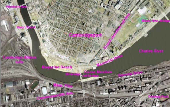
Here is my marked up satellite photo from the regional transit agency showing the key area targeted by the destructive duo.


The spaghetti on the left is the area Harvard is targeting for its relocated Medical School one of these Centuries.  The Mass. Pike runs out of it left to right and west to east through the middle and then along the bottom.  Below the Mass. Pike on the left is Boston University.  Above the Mass. Pike is the Charles River and then Cambridge.  The BU Bridge goes straight through the middle, with the Grand Junction railroad bridge under it.

Harvard owns pretty much all of the land covered by the MassDOT study.  Harvard's ownership is subordinate to use for transportation purposes.

Harvard bought its holdings several months after the local transportation agency, the MBTA released a report saying that the railroad bridge under the BU Bridge could be converted to an off ramp from the Mass. Pike to Cambridge.

After issuing the report, the MBTA “realized” that the costs of the project would be too much to pay, given the supposed purpose they were researching, Express Bus service from the Newton Suburb to Cambridgeport / Kendall Square.  The MBTA came to this “realization” with a straight face, inasmuch as the MBTA was talking about, probably, two or three express buses in in the morning and two or three back in the evening.  It does not take an abacus to calculate that such construction would not be justified by two or three round trips of one express bus Monday through Friday.

A lot of the environmental outrages being inflicted on the Cambridge side can be explained as readying Cambridge to received traffic from the Mass. Pike via such a bridge.


2. Destruction of the Wild Area, Stalking Horse for Mass. Pike Off Ramp to Cambridge.

The first presenter last night gave a pitch for the usual stalking horse / bike highway on the Grand Junction railroad bridge.

He described his proposal as providing access from the main BU Campus to BU’s Cambridge Boathouse east of the Wild Area, which in turn is east of the Grand Junction Railroad Bridge.

English translation: he wants to destroy the Wild Area between the Grand Junction railroad bridge and the BU Cambridge Boathouse.

The Wild Area is the next area east of the Destroyed Nesting Area of the Charles River White Geese, on the east side of the Grand Junction railroad.  The Charles River White Geese have been forced to use the Wild Area for nesting because of all the destruction of ground vegetation.  In the worst weather, the Charles River White Geese can be seen in the waters off the wild area seeking protection not available in the Destroyed Nesting Area.

Here is a view of the access to the railroad bridge on the Boston side.  The southern edge of the bridge is the metal pieces showing at the bottom.  If you look closely straight ahead, you will see a green sign above the Mass. Pike.

This highway proposal would cross the bridge running from the Mass. Pike and turn and run (left, behind the camera) through the Wild Area to the BU Cambridge Boathouse.


One of the first happenings after the falsely named Charles River “Conservancy” starting destroying the environment for the Department of Conservation and Recreation was the destruction of all ground vegetation in the Wild Area.

One of the second happenings after the Charles River "Conservancy" started the environmental destruction for the DCR was the destruction of most of the ground vegetation in the Destroyed Nesting Area west of the Grand Junction railroad bridge.

Omitted from destruction in the Destroyed Nesting Area was that area in and near the area which the DCR wanted to destroy as part of the rebuilding of the BU Bridge.

At least one depiction of the off ramp from Mass. Pike to Cambridge showed an access ramp going through the Wild Area.  It is no coincidence that the supposed bike highway would connect to the BU Boathouse through exactly that path.  Such a route would create most of the off ramp desired for the ramp from the Mass. Pike.

Here are the DCR plans for destruction of the Wild Area as part of the DCR’s proposed destruction of hundreds of trees between the BU and the Longfellow Bridge, the second bridge east of the BU Bridge.


The impact of the DCR plans is the same in the two versions of the plans not kept secret, plans dated 2003 and 2009.  The current game is maximum secrecy, maximum damage. $20 million was bless by the legislature in 2014.

The DCR plans show exactly one tree not being destroyed.  They do not deign to mention anything else.  Dishonesty is the norm dealing with these people.

Here is the BU satellite photo showing the Wild Area published in 2014.


Here are photos by me of the Wild Area from the BU Bridge taken last winter and a week or so ago.


The small white figures in the immediately above photo are members of the gaggle of the Charles River White Geese.

Here is a photo from the worst of last winter of the Charles River White Geese swimming in the apparently only part of the Charles River not frozen over at that time.  The photo is taken through the Wild Area.


All trees between the Grand Junction railroad and the yellow BU Boathouse would be destroyed but one.


3. The Architects’ Proposal.

MassDOT’s most recently announced plan would rebuild the Mass. Pike in the narrow part of the photo area of the first photo, between the BU Bridge and Harvard’s property to the left.

MassDOT’s proposal is responsible.  Most of the road in this area is on stilts, starting at about the Grand Junction and going west.  They would tear it down and rebuild it pretty much in place.  Part of the adjoining Soldiers’ Field Road would be moved under the Mass. Pike to allow minor widening, with all of the widening toward Soldiers’ Field Road and the Charles River.

The Architect proposal would rebuild it on the ground with extensive parts of their related items built at least in part on a new retaining wall which would destroy the animal habitat on the edge of the river and any inconvenient trees.  They would probably cantilever above the river.

The Architect giving the presentation, among other examples, show irresponsibly built parts of the river roads abutting the Charles River as good examples of what he was proposing.

His argument basically was that they had done this sort of thing before, why not again?

A lot of responsible people condemn the same construction as irresponsible behavior which should not be repeated, much like dumping waste in Boston Harbor.  At the same time as this construction was being done on the Charles, waste was being dumped in Boston Harbor.  The “responsible” architect did not extend his comparison to the obvious irresponsibilities of his comparisons.


4. Related matters.

I submitted written comments which were an expansion of my most recent report, posted at http://charlesriverwhitegeeseblog.blogspot.com/2015/09/charles-river-massdot-plan-for-mass.html.

There were significant changes, but the entire thing really is too big for one report.  I will follow up with portions.

Clearly these presentations were irresponsible.

The pitch they are giving, in addition to supposed glorious ideas, was allegations of cost savings.

This could be dangerous.

We have a commendable agency, MassDOT, whose responsibilities were expanded by the legislature by giving MassDOT major responsibilities of the now deceased Metropolitan District Commission.  The rest of the MDC was folded into the DCR.

The legislature achieved part of its goals in putting a responsible agency, MassDOT, on the Charles River bridges.  MassDOT has been commendable in standing up to outrages from DCR / Cambridge government types on the Charles River and has been commendable in standing up to similar outrages on the Grand Junction.

The folding of the MDC into the DCR was a waste of time.  The MDC lives without meaningful change except in name.  It is silly to make a distinction between MDC before and DCR after.  They are both vile and very compatible with the destructive City of Cambridge, MA.

And we have a ramping up of DCR / Cambridge type fight for destruction on the Charles River.

Friday, September 11, 2015

Charles River, MassDOT Plan for Mass. Pike, Irresponsible environmental manager, irresponsible alternate proposals.

Charles River, MassDOT Plan for Mass. Pike, Irresponsible environmental manager, irresponsible alternate proposals.

0. Introductory.
1. Summary.
2. One very telling piece of the DCR’s Record — the Creation of an annual blight by the DCR's  use of poisons on the Charles River..
3. The DCR adds Contempt for Resident Animals to its Contempt for the Land and Water of the Charles River.
4. The DCR uses blatant lies in its fight for destruction on the Charles River.
A. General.
B. Lies in the attacks on the Charles River White Geese.
C. Lies in the construction of the bizarre wall walling off the Magazine Beach playing fields from the Charles River.
D. Lies in the reduction of playing fields at Magazine Beach.
E. Lies in the DCR's fight to destroy hundreds of trees between the BU and Longfellow Bridges.
F. Fight for destruction by the falsely named Charles River “Conservancy.”
G. The latest project of the fighters for destruction — the Grand Junction outrage.
H. Some Destruction by the falsely named Charles River “Conservancy:”
I. The most visible victims of these multiple outrages — the Charles River White Geese.
J. More destruction in the Destroyed Nesting Area of the Charles River White Geese — Railroad Worker destruction blessed by the DCR in spite of Cambridge Conservation Commission objections.
K. Cambridge’s planned destruction in the Destroyed Nesting Area and the Wild Area.
L. The DCR is unfit for environmental management in general and, in particular, management of the open space being created.
M. Have the legislature prohibit this irresponsible entity from responsibility for the new open space and Soldiers Field Road.
5. The DCR’s Cheerleaders and related, fighting for more destruction, should be rejected along with the DCR whom they idolize.
6. Use the terrible DCR Record as the basis for prohibitions in use of created open space.
7. Green Line A spur from Comm. Ave. and the BU Bridge in Boston to Harvard Station in Cambridge.
8. The context.


0. Introductory.

This report, of necessity, only reflects a tiny part of the problem with the Department of Conservation and Recreation and its friends, whether declared friends or supposedly independent.

The original draft was written on my smart phone on the set of a major movie on which I was working, during down time in “holding.”  The original drafts has been expanded and clarified, but the core is unchanged.

I am amazed at how much good work I got done under those circumstances, and amazed at the subsequent amount of work which was necessary to expand, refine and clarify while realizing that very major parts of this terrible record must, of necessity, be omitted.

Here are the most recent plans of the Massachusetts Department of Transportation for the largest part of the work they are doing on the Mass. Pike at the future home of the Harvard Medical School.  The Charles River is on the right.  The proposed new green space is the area marked green abutting the Charles River.


The lower right corner of the above map shows on the left of my following marked up edit of an MBTA provided apparent satellite photo.  That area is still present.  It is under the proposed rearrangement of the Mass. Pike in the above plan.

The Magazine Beach playing fields are above the Charles River.  In the middle of the photo is the BU Bridge.  Running under the BU Bridge from left to right is the Grand Junction railroad bridge.


1. Summary.

The biggest defect in the current plan of the Massachusetts Department of Transportation for the rearrangement of the Massachusetts Turnpike (I90) on the Boston side of the Charles River is the reprehensible record of the entity which has charge of the environmental improvements which would be created.

The biggest problem with too many those who want the most important changes to the MassDOT plan is that too many of the change seekers are hand in glove with the environmentally destructive entity which is the likely manager of the environmental improvements and are fighting for the destructive cause of that vile organization.

It must be recognized that this report, of necessity, is a very abbreviated report of the vile record of the DCR and its fellow destroyer, the City of Cambridge.


2. One very telling piece of the DCR’s Record — the Creation of an annual blight by the DCR's use of poisons on the Charles River..

One, and by no means not the only, excellent example of the problem with the Department of Conservation and Recreation is the annual algae infestation on the Charles River.

This infestation originates in the DCR’s love of dumping poisons on the banks of the Charles River.  Several years ago, their beloved poisons were not performing up to snuff at Ebersol Field near Massachusetts General Hospital.   MGH, in turn, is located not far from the dam which turns the eastern end of the Charles River into a managed pond.

So the DCR dumped on Ebersol Field poisons marked “Do not use near water.”

The next day, the Charles River was dead with algae from the harbor to the Mass. Ave. Bridge.

Since then, this outrage is an annual infestation.


3. The DCR adds Contempt for Resident Animals to its Contempt for the Land and Water of the Charles River.

The DCR adds to its contempt for its land and its waters contempt for the animals who live there whom it has a duty to protect.

The DCR’s “master plan” for the Charles River calls for the killing or driving away of all animals residing there.

The bizarre wall the DCR has built walling off the Magazine Beach playing fields from the Charles River has no apparent purpose except to starve the 34 year resident and valuable tourist attraction, the Charles River White Geese.

This bizarre 14 foot high wall of introduced vegetation exists nowhere else on the Charles River Basin.  It has only one tiny opening, the former location of a boat ramp which was destroyed by the DCR without explanation.

Here are some photos of this introduced wall.

The first photo is from the Boston side of the Charles River.


The tiny figure is that of an adult woman.  She is standing in the only opening of this outrage.


This is a before picture.


The bizarre work at the playing fields included the addition of a series of massive, never trimmed, bushes to block off the only opening to the Charles River White Geese.  This outrage makes entry by the Charles River White Geese impossible.


4. The DCR uses blatant lies in its fight for destruction on the Charles River.


A. General.

Added to the contempt for water, land and animals, is the flat out lying by which the outrages are achieved.


B. Lies in the attacks on the Charles River White Geese.

In the Boston Sunday Globe’s section leading report of the DCR’s commencement of this heartless abuse of the Charles River White Geese, the Globe combined a telling photo with their quote of a flat out lie which has been repeated by the DCR for most of the last 15 years.

The photo was that of a small goose standing next to and overwhelmed by earthmoving equipment being used to take away its food and its home at Magazine Beach by keeping it from the playing fields.

The flat out lie was printed right next to that photo.  The key manager never stopped lying of his lack of intention to harm the beautiful animals he and the DCR have been heartlessly abusing.  Except in small meeting when he claimed the right to this heartless abuse was justified by the irresponsible provisions in the “Charles River Master Plan.”

That Charles River Master Plan calls for the killing and / or driving away of all resident animals on the Charles River Basin.

Here is a photo of friends of the Charles River White Geese feeding the hungry animals when they were first deprived of their food and home of most of the last 34 years.


And cheerleaders praise the heartless abuse of this valuable gaggle which has survived on its own for 34 years in the middle of civilization, loved by decent human beings and an active tourist attraction until the heartless abuse.


C. Lies in the construction of the bizarre wall walling off the Magazine Beach playing fields from the Charles River.

The bizarre wall was implemented as a blatant falsehood in violation of yet another provision of that “Charles River Master Plan.”  That was the direct promise to build a lawn to the river.  When the DCR, by the introduction of the bizarre wall, proved that the DCR was lying, the DCR simply changed the lie after the fact.

The DCR’s official explanation of the starvation wall may be that proclaimed by the falsely named Charles River “Conservancy.”  The CRC conducted a swim in to brag of the IMPROVEMENTS TO SWIMMING supposedly provided by the poisons and by the bizarre wall constructed by the DCR and Cambridge.


D. Lies in the reduction of playing fields at Magazine Beach.

The DCR also promised improvements to the playing fields.  This was proven a lie by the destruction of playing field space to put in an expensive drainage system to drain off the DCR’s beloved poisons. ..

The DCR and Cambridge destroyed native grass on the playing fields which had survived without poisons for the better part of a Century.  The DCR and Cambridge then destroyed the playing fields to drain off the poisons being dumped on the shores of the Charles to keep alive sickly grass which has no business on the banks of the Charles.

The DCR’s beloved poisons and sickly grass have been ineffectual.  The sickly poison drinking grass which replaced responsible grass is scheduled to be destroyed again.  It is scheduled to be rebuilt and replaced with more poison drinking sickly stuff.  Additionally, the DCR wants to destroy the responsible native grass on the hillside to the west of the playing fields and the responsible native grass in the wetlands behind the swimming pool.

You guessed it.  They are putting in more sickly grass which needs poisons, poisons not needed by the responsible NATIVE grass they want to add to their destructive record, and which has survived responsibly for the better part of a Century.


E. Lies in the DCR’s fight to destroy hundreds of trees between the BU and Longfellow Bridges.

You add to this the fight to destroy hundreds of excellent trees between the BU and Longfellow Bridges.  The “explanation” for this outrage varies with the audience.

The earliest “explanation” for the destruction translated as “won’t it look great in 40 years.”

In 2009, the Boston Globe did a story on the DCR seeking Obama recession fighting moneys to destroy the hundreds of trees currently threatened.  The lie then was that the DCR was DESTROYING ONLY SICKLY TREES.  I have the plans and am happy to provide them.  As may be readily observed, none of the targeted trees are diseased, and none of the destruction plans call any of them diseased.

But the Boston Globe thought they were dealing with a responsible agency and the Boston Globe happily printed this blatant lie.

In 2014, the State House blessed the destruction with an allocation of $20 million.

Here are some of the targeted, excellent trees.  It really is impossible to fully communicate the scope of this outrage.

The first tree looms over the Destroyed Nesting Area of the Charles River White Geese.  It is located very close to the BU Bridge.


Destruction plans are posted at http://charlesriverwhitegeeseblog.blogspot.com/2014/04/tree-destruction-plans-charles-river.html


F. Fight for destruction by the falsely named Charles River “Conservancy.”

The falsely named Charles River “Conservancy” bragged when money was first put on the table in the 2014 legislative cycle that the money was the implementation of a petition the CRC had distributed WHICH MADE NO MENTION OF MASSIVE TREE DESTRUCTION.  Naturally, this falsely named group used the latest excuse for massive destruction.

The project which this destructive entity obtained signatures in support of for was an irresponsible project to create “underpasses” under the next three bridges.  MassDOT, being a responsible agency has condemned this project as environmentally irresponsible and a waste of state money.


G. The latest project of the fighters for destruction — the Grand Junction outrage.

Now a lot of people who fought for all of this irresponsible destruction, and who want the irresponsible DCR to manage the MassDOT proposed increase in open space in Boston, are spouting pious about spending money on yet another destructive project.  Their latest supported outrage involves more destruction on the Cambridge side of the Charles River as a result of the misuse of the Grand Junction railroad bridge.

The DCR’s tree destruction plans call for all trees EXCEPT ONE to be destroyed in the Wild Area between the railroad and the BU Boathouse.

Here is the relevant part of their destruction plans.  The broken lines running from bottom to top in the middle of the plan is the Grand Junction railroad.  To the right of the plan is BU's Cambridge Boat House.  The DCR shows one tree NOT destroyed.  They do not even dignify the massive destruction by pointing out destroyed trees.


Here is what the targeted dense woods, the Wild Area look like now.  The above plan would destroy EVERY tree BUT ONE between the Grant Junction railroad bridge and the (yellow) BU Cambridge Boathouse.

This picture was taken in the worst of the last very bitter winter.


This photo was taken September 12, 2015, during the preparation of this blog report.  The small white figures are part of the Charles River White Geese.


Here are the Charles River White Geese in the water beneath the Wild Area during that terrible winter.  This was the only free water available..


Here is an older picture of the desperate Charles River White Geese hunting for some food in the railroad right of way.


H. Some Destruction by the falsely named Charles River “Conservancy:”

The falsely named Charles River “Conservancy” has, by agreement with the DCR, acted as environmental destroyer for the DCR.  After the agreement, all ground and hillside vegetation was destroyed in the Wild Area between the Grand Junction and the BU Boathouse.  This is the same heavily treed area where the DCR plans call for destruction of all trees but one.

About half the ground vegetation in the area between the railroad and the BU Bridge was destroyed.  The DCR’s overly destructive BU Bridge repair plans destroyed most of the undestroyed ground vegetation.  “Remediation” of the DCR’s destructiveness in the BU Bridge repair plans has been nonsensical.  To the extent introduced vegetation lives, it is vegetation comparable to the irresponsible stuff walling off the Charles River from the playing fields.


I. The most visible victims of these multiple outrages — the Charles River White Geese.

Who does this heartlessly abuse?  The Charles River White Geese, of course.


This area is the portion of their habitat they used as their Nesting Area and for protection during bad weather.  It was lush and beautiful, supporting a variety of wild animals, all condemned by the vile provisions in the Charles River Master Plan to kill off or drive away all resident animals.


The 34 year resident Charles River White Geese are confined to this destroyed area without food.

The DCR have made it worse.


J. More destruction in the Destroyed Nesting Area of the Charles River White Geese — Railroad Worker destruction blessed by the DCR in spite of Cambridge Conservation Commission objections.

The Cambridge Conservation Commission condemned irresponsible use of the not destroyed portion for parking on a project on the tracks by railroad workers.  They were too lazy to park next to Memorial Drive in a manner comparable to the responsible parking accomplished by MassDOT in its implementation of the DCR’s irresponsible BU Bridge repair plans.


So the DCR told the workers to get out of the tiny portion of the area in the CCC’s jurisdiction.  The DCR BLESSED THE IRRESPONSIBLE AND DESTRUCTIVE PARKING elsewhere, which added to the destruction of the ground vegetation and which destroyed larger vegetation.

The DCR’s bedfellows dumped crushed stone in this previously lush area.  When they left an additional load of truck stone was dumped in the area after parking use had ceased.


MassDOT implemented the DCR's plans for BU Bridge repair as responsibly as possible, with none of this outrageous parking.  Here are two photo of the highway ramp where responsible management would have parked.

Under the Memorial Drive overpass was being used for another project (the fence).  There was still plenty of room to park to the left of the on ramp, if the people in charge are / were fit for their jobs.  The corner to the right in the first photo is the entrance to the Destroyed Nesting Area.


The next photo shows the staircase illegally constructed by Boston University at about the location of the car further away in the above photo.


These photos show the horrible walk these husky workmen would be faced with if they were too lazy to climb the stairs.  This and a related walk are the only places crushed stone should be placed.  Both are in the BU Bridge repair area and supposedly are remediation.


K. Cambridge’s planned destruction in the Destroyed Nesting Area and the Wild Area.

Cambridge has its own destructive plans which include building in the Destroyed Nesting Area and building a fence preventing direct access between the Destroyed Nesting Area.  The Charles River White Geese have been forced to nest in the dirt of the Wild Area because it is less destroyed than the Destroyed Nesting Area.

Cambridge pols are publicly campaigning for the destruction with the usual lies of omission.  They praise the overall proposal and “neglect” to mention the destruction and heartless animal abuse on the banks of the Charles River.

Here is a copy of the plan the Cambridge pols keep as secret as possible.


Not only should the environmental outrages on the Cambridge side not be expanded as part of the Mass. Pike work, this irresponsible, rogue department should have no responsibilities for any area created as part of the Mass. Pike work.


L. The DCR is unfit for environmental management in general and, in particular, management of the open space being created.

Ideally, the DCR should be barred from management of the open space being created and barred from Soldiers Field road.


M. Have the legislature prohibit this irresponsible entity from responsibility for the new open space and Soldiers Field Road.

The legislature, in its wisdom, has shown its contempt for the DCR / its predecessor by transferring the river bridges to MassDOT.

The truly irresponsible DCR should be barred from any expansion of its irresponsible behavior, and from management of Soldiers Field Road..


5. The DCR’s Cheerleaders and related, fighting for more destruction, should be rejected along with the DCR whom they idolize.


And its cheerleaders, including those complicit in this terrible record of the DCR, should simply be treated with the lack of respect due the destructive agency they support without condition.

Harvard bought the prime area of this study a few month's after the MBTA showed how this railroad and railroad bridge could be converted to an off ramp from the Mass. Pike to Cambridge.  So many outrages fit a pattern of upgrading Cambridge to handle this traffic.  So we get lovely sounding con games.


6. Use the terrible DCR Record as the basis for prohibitions in use of created open space.

The terrible DCR record should stand, at minimum, as the basis for a point by point prohibition of action in Boston which follows on the outrages in Cambridge.  Description of prohibited acts should point by point condemn further outrages and lying by the DCR in Boston.

Naturally, this is only a far inferior alternative to barring the DCR from the created lands and Soldiers Field Road because of its proven irresponsibility.


7.  Green Line A spur from Comm. Ave. and the BU Bridge in Boston to Harvard Station in Cambridge.

This is an ideal time to go forward with this project, which is badly needed by the residents and employers of North Allston.

I have provided an extensive series on this matter.  The most recent report is at http://charlesriverwhitegeeseblog.blogspot.com/2015/07/charles-river-olympics-rapid-transit_23.html

8. The context.

Here are 33 photos of destruction in Cambridge of which the Charles River outrage is just a part.

http://charlesriverwhitegeeseblog.blogspot.com/2015/05/charles-river-more-money-for.html.
Wednesday, September 02, 2015

The Charles River: MassDOT, the Mass. Pike work, and a good meeting.

1. Apologies.
2. MassDOT and the Mass Pike Rearrangement.
A. Introductory.
B. Good meeting.
C. Boston Redevelopment Authority.
D. Harvard University.
E. Excellent guest.
3. Summary.


1. Apologies.

This is the second of three reports I have been promising.  I was very pleased with my photos in the report I have published.

It looks like the report on the Muddy River Canada Goose situation will not go forward, for technical reasons.

I have deferred the most important report of the three, in part because I really want to get this one right.  Another reason was that I was very happy with the photo report being on top.  Prominently featured in the first report is a beautiful goose whom I am very pleased to brag about.


2. MassDOT and the Mass Pike Rearrangement.

A. Introductory.

I have been issuing many reports on the series of meetings conducted by MassDOT (the Mass. Department of Transportation) concerning their anticipated rebuilding of I90 (Mass. Pike) on the South Side of the Charles River across from the habitat of the Charles River White Geese.  Now is the time to get into true environmental issues.

In the August meeting, the staff attempted to leave an opening for structured new comments from the group.  That has turned into what appears to be a major opening for comments in the next meeting.

Here are MassDOT plans of the current situation and the apparent plans for the rearrangement as those plans currently stand.


B. Good meeting.

The staff scheduled several very well done presentations.

The technical presentations were particularly useful.  Unfortunately, they really do not come into the scope of this blog, so I will just leave that as a deserved compliment to them.

Two presentations were within the area our interest, from the Boston Redevelopment Authority, and Harvard University.

C. Boston Redevelopment Authority.

The BRA is a nominally independent body which really is the Mayor’s planning arm.  Within the structure of the City of Boston, it has considerably more power than the usual planning department.

The BRA is hiring a consultant who will be on board quickly and issue a report next year to the BRA on the consultant’s evaluation of the plans.

D. Harvard University.

Harvard sounded like Harvard.

Harvard is seeking an agreement with MassDOT on the details of the rearrangement.  Since Harvard pretty much owns all the land in question, an agreement makes good sense.

The presentation, however, was true Harvard.  Harvard presented their PROPOSAL as if it were written in stone and WOULD be the reality.

Hubris, to put it mildly.

Harvard purchased the land in question several months after a report issued by the public transit agency, the Metropolitan Boston Transportation Authority.

The property contains a lot of spaghetti, the exit from the Mass. Pike to the Brighton neighborhood of Boston and to Cambridge.

It also contains the vestiges of a once massive railroad yard, the Beacon Yard.  That has moved to Worcester except for a few facilities needed by the state for the regional state system.

The MBTA report indicated that an off ramp was possible to Cambridge over the Grand Junction railroad bridge from the Mass. Pike.  A whole bunch of destruction on the Cambridge side, planned or accomplished smells like bureaucrats, etc., preping the place for the Off Ramp.

Promptly occurring on the Boston side was a change in the Mass. Pike spaghetti which rendered the off ramp more workable.

Some bureaucrats tried to deed the place to Harvard without restriction.

The legislature caught them.

The legislature made the transfer contingent on continuing to provide transportation needs of the community.

Harvard conveniently ignored the severity of the legislative limitation on its ownership.

E. Excellent guest.

I brought to the meeting a visiting professor from the University of Graz in Austria, Professor Robin Pope.

I have shown Robin around the situation on the Cambridge side of the Charles River because of her interest in the Charles River White Geese.

She neglected to mention that she is a transportation expert.  And a clearly impressive speaker.

She did me proud.  She made some excellent comments and displayed good grasp of the issues, including the limits of building transportation upon transportation upon transportation.

And she very effectively put in a good word for the Charles River White Geese.

She made me proud.

Here are some views she had of the Charles from the Hyatt Regency Hotel, where she has been staying.  I led with one of my photos.  The Hyatt Regency is on the north side of Memorial Drive heading east.  In buildings of importance, going east from the Destroyed Nesting Area and the Wild Area, first comes Boston University’s Cambridge Boat House on the river, and then comes the Hyatt.

The photos show Memorial Drive and the Charles directly in front of the hotel, the Charles and Boston to the east of the hotel, and the Charles to the west of the hotel.  The last photo shows BU's Cambridge Boat House, the Wild Area, the Grand Junction Railroad Bridge, and the BU Bridge, respectively.


The lead photo to this blog report is a more distant version of the last photo.  The two massive buildings in the upper right of the lead photo are Boston University’s massive, rather new, dormitories which are a few buildings from and which tower over the area that Harvard owns and MassDOT is rearranging.

3. Conclusion.

OK, I have given you the basics of the meeting.

Next will come the policy coming up in the next meeting.  This will include photo, maps, etc.

This is the difficult part.  But this is a logical separation of reports.

Sunday, August 23, 2015

The Charles River White Geese in the Heat of Summer

The Charles River White Geese in the Heat of Summer


1. Introduction.
2. Photos.

1. Introduction.

I have three stories pending.  I am doing them in the order that my personal work effort has progressed.

Today, I will show you photos of the Charles River White Geese from last Wednesday, August 19, 2015.

My next report will likely be of a report I am getting concerning the treatment of Canada Geese by the Department of Conservation and Recreation (the Dreaded DCR) or the City of Boston in the Muddy River Reservation.  This reservation is a mile or so south of the BU Bridge on the road which crosses the BU Bridge.  I hope I have the name correct.  The naming situation is similar to that of highways in the New England area, use as many different names as possible for the same entity.  That will confuse drivers and make the situation that much more dangerous.

After that, I anticipate I will report of the MassDOT meeting, also on Wednesday, which showed some fruitful sparks.  MassDOT has been the adult in the room with the Dreaded DCR and the City of Cambridge.  Among other things being discussed is introduced parkland on the Boston side of the Charles River.  One suggestion I will have is that MassDOT gets very specific to prevent more environmental irresponsibility by the Dreaded DCR.

2. Photos.

It was a hot day, in the 90s.

The destructiveness of the Dreaded DCR is particularly apparent.

The Dreaded DCR’s designated environmental destroyer, the falsely named Charles River “Conservancy” did major destruction of ground vegetation promptly after being designated by the DCR as its agent for environmental destruction.  They destroyed as much ground vegetation as was feasible, given plans for excessive destruction as part of the Dreaded DCR’s BU Bridge repair plans.  That destruction was at least 50% more than was necessary.

The Dreaded DCR then made things worse by allowing /encouraging use of this sensitive area for parking by railroad workers when parking was readily available next to Memorial Drive.  MassDOT did responsible parking implementing DCR plans for the BU Bridge work.  DCR lowered itself to its proudly vile level.

The Cambridge Conservation Commission objected to the destructive parking.  The DCR told the workers to back up beyond the tiny CCC jurisdiction.  The stones were dumped on the ground apparently gratuitously.


The first photo is in the area of the Dreaded DCR blessed destruction under a magnificent tree, an area which used to be heavily vegetated and beautiful.

The second photo includes area within the jurisdiction of the CCC, near the river.  Destruction had already been accomplished and the Dreaded DCR would not show any decency, of course.

Here are a couple of photos of the Charles River White Geese enjoying the water and apparently preparing to go in.


In the first photo, the goose with black markings, on the right, is a second / third generation goose descended either from Brown Beauty, the White China female with vestigial Brown China Markings who was the daughter of Bumpy, or from the Brown Toulouse who was abandoned in 2000 and found a mate in the gaggle.

Third from the right in the first photo and at the very right in the second photo is the male White China with vestigial Brown China markings, he was bred in 2005.

The two photos I led with above are enlargements of the following two photos, cropping into the featured birds.

Here is a solo photo of the brown male.


Here is a photo of the apparent survivor of two sibling Pekin Ducks abandoned in 2006.


The Charles River White Ducks were found by a large group of us doing a memorial service on the fifth anniversary of the assassination of Bumpy, the then long time leader of the gaggle.

The Charles River White Ducks were so innocent that they thought dogs were their friends.  I saved one of them that day by kicking a dog who had his teeth on the neck of one of them.

The head of the Charles River Urban Wilds Initiative showed the Charles River White Ducks what that blue stuff was for by backing into the Charles River while hand feeding the siblings.  Once the siblings found out what the blue stuff was all about, they took to the Charles River like ducks to water.

In the photo, there are two female Mallard Ducks below the White Ducks survivor.  The two White Ducks added one of Mallard females as a friend quite awhile ago.  I have had extended periods when I was not certain if one of the two White Ducks had passed away because I would only see one of the White Ducks with their female friend for extended periods. The missing member eventually showed up again, perhaps having attempted to nest.  Most recently, it has looked like the current threesome.

Here is a photo from 2008, courtesy of Phil Barber, showing the Charles River White Ducks, Daphney and Mandrake.


I have a Phil Barber photo of them which I looked for and have not found.  It shows the proud pair with their then brood on the Charles River.  No member of the brood survived.  Our guess has been that the babies were prey to hawks, and the parents, not having been raised in the wild, did not have the skills to know how to defend / hide the babies from threats.

And here is a photo of the same area as above from the BU Bridge, in the manner of my last group of photos.


Here are examples of nature healing the outrage created by the Dreaded DCR.


The gray line is a plastic wall that separated the BU Bridge work / “replacement” area from the area destroyed by the Charles River "Conservancy."  The large bushes are native bushes remaining after the vile attacks.  The vegetation on the ground is runners from the undestroyed native vegetation.  Nature is healing itself.

And all those stones are the Dreaded DCR / its accomplices bragging about their rottenness.